
Lake Yuriria facts for kids
Quick facts for kids Lake Yuriria |
|
|---|---|
.jpg) |
|

Lake Yuriria
Location in Guanajuato

Lake Yuriria
Location in Mexico
|
|
| Location | Guanajuato, Mexico |
| Coordinates | 20°14′51″N 101°8′58″W / 20.24750°N 101.14944°W |
| Type | Reservoir |
| Native name | Laguna de Yuriria (Spanish) |
| Primary inflows | canal to the Lerma River |
| Primary outflows | canal to the Lerma River |
| Catchment area | Lerma River |
| Basin countries | Mexico |
| Surface area | 7,200 ha (18,000 acres) |
| Max. depth | 2.6 m (8 ft 6 in) |
| Surface elevation | 1,730 m (5,680 ft) |
| Settlements | Yuriria |
| Official name: Laguna de Yuriria | |
| Designated: | 2 February 2004 |
| Reference #: | 1934 |
Lake Yuriria, also known as Laguna de Yuriria in Spanish, is a large man-made lake in central Mexico. It's located in the state of Guanajuato. This lake has been around since the 1500s. It helps local farms by providing water for their crops. Lake Yuriria is also a very important home for many water birds. Because of this, it's recognized as a special wetland around the world.
Contents
Where is Lake Yuriria?
Lake Yuriria is found in the southern part of Guanajuato state. It sits in the area drained by the Lerma River. The lake is west of the Lerma River and is connected to it by a canal. The town of Yuriria is right on the southern edge of the lake. The lake itself is inside the Yuriria Municipality.
Size and Depth
The lake covers a huge area of about 7,200 hectares (that's like 17,800 acres!). It's usually quite shallow, with its deepest point being only about 2.6 meters (8.5 feet).
Water Flow and Use
A special canal links Lake Yuriria to the Lerma River. This canal helps refill the lake when there's a lot of rain. During dry times, water from the lake is sent through irrigation channels to nearby farms. This helps farmers water their crops. Gates control how much water flows in and out of the lake from the Lerma River.
Nearby Lakes
To the north of Lake Yuriria is Lake Cuitzeo. Lake Cuitzeo is mostly a closed lake, meaning its water doesn't usually flow out to other places. However, a long time ago, it used to overflow into Lake Yuriria. Lake Cuitzeo's water is a bit salty, so it's not good for watering crops. Because of this, a wall was built in the 1800s to stop its water from flowing into Lake Yuriria.
History of Lake Yuriria
The name "Yuriria" is a shorter version of Yuririapundaro. In the Purépecha language, this means "lake of blood." Before the Spanish arrived, the lake was part of the Purépecha Empire.
Building the Canal
The canal that connects the lake to the Lerma River was built in 1548. A friar named Diego de Chávez, who was an Augustinian monk, directed its construction. This canal is one of the very first big water engineering projects in colonial America. Friar Diego de Chávez also started building the Augustinian monastery in the town of Yuriria, which is on the lake's southern shore.
Plants and Animals of Lake Yuriria
Lake Yuriria is a very rich environment for plants and animals. The water is full of nutrients, which means there's lots of aquatic plant life. However, this also means the water isn't very clear.
Bird Life
The lake is a super important home for many birds, especially those that migrate. Between 1981 and 1997, 142 different kinds of birds were seen here. Out of these, 44 species were water birds!
Some of the cool birds you might find include:
- The red-tailed hawk (Buteo jamaicensis)
- The peregrine falcon (Falco peregrinus)
- The blue-winged teal (Spatula discors)
- The American wigeon (Mareca americana)
- The Mexican duck (Anas diazi)
- The American white pelican (Pelecanus erythrorhynchos)
- The Townsend's solitaire (Myadestes townsendi)
- The black-vented oriole (Icterus wagleri)
- The hooded oriole (Icterus cucullatus)
- The black-polled yellowthroat (Geothlypis speciosa)
Because so many important birds live here, Lake Yuriria has been named an Important Bird Area.
Surrounding Area
The land around the lake is part of an area called the Bajío dry forests. This ecoregion has its own special types of plants and animals adapted to drier conditions.
Protecting Lake Yuriria
In 2004, Lake Yuriria was given a special status. It was named a wetland of international importance under the Ramsar convention. This means it's recognized globally for its important natural features. The Ramsar site covers a large area of 15,020 hectares, which includes the entire lake and all the land around its shore. This helps protect the lake and its wildlife for the future.
Images for kids
-
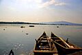
Lake Yuriria in Guanajuato
See also
 In Spanish: Laguna de Yuriria para niños
