Lamar, Oklahoma facts for kids
Quick facts for kids
Lamar, Oklahoma
|
|
|---|---|

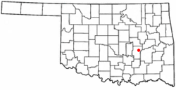
Location of Lamar, Oklahoma
|
|
| Country | United States |
| State | Oklahoma |
| County | Hughes |
| Area | |
| • Total | 11.99 sq mi (31.07 km2) |
| • Land | 11.99 sq mi (31.06 km2) |
| • Water | 0.00 sq mi (0.00 km2) |
| Elevation | 751 ft (229 m) |
| Population
(2020)
|
|
| • Total | 118 |
| • Density | 9.84/sq mi (3.80/km2) |
| Time zone | UTC-6 (Central (CST)) |
| • Summer (DST) | UTC-5 (CDT) |
| ZIP code |
74850
|
| Area code(s) | 405 |
| FIPS code | 40-41250 |
| GNIS feature ID | 2412872 |
Lamar is a small town located in Hughes County, Oklahoma, in the United States. In 2010, the town had a population of 158 people. By 2020, the population was 118.
History of Lamar
Lamar began to grow in 1907. This happened after the Missouri, Oklahoma and Gulf Railway built a train line. This line connected the towns of Dustin and Calvin. Lamar was located right in the middle of these two towns.
A post office opened in Lamar on July 23, 1907. Soon after, on September 14, 1907, the first newspaper, the Lamar News, was published. By 1909, Lamar had many businesses. These included a bank, a cotton gin, and several general stores. The town officially became a city on January 2, 1908.
In 1909, about 500 people lived in Lamar. The citizens voted to build a new school. This two-story brick building was finished in May 1910.
On July 5, 1922, Lamar's school district joined with others. This created a larger, "consolidated" school district. In October of that year, people voted to officially make Lamar an incorporated town. This meant it had its own local government.
The first official count of people in Lamar was in 1930. It showed 250 residents. The population grew to its highest point of 296 in 1940. After that, the number of people slowly went down. By 1990, only 97 people lived there.
Around the year 2000, Lamar had 172 residents. Many of them traveled to other towns for work. The town served as a "bedroom community." This means people lived in Lamar but worked elsewhere. The 2010 census counted 158 people.
By 1918, the area around Lamar was mostly farms. There were businesses that supported farming, like cotton gins and blacksmith shops. The town also had churches and a weekly newspaper called the Lamar Sun.
Geography of Lamar
Lamar is located in the eastern part of Hughes County. It is about 7 miles (11 km) east of Horntown. It is also about 15 miles (24 km) east of Holdenville. Holdenville is the main town, or county seat, of Hughes County.
The town of Lamar covers an area of about 11.99 square miles (31.06 square kilometers). All of this area is land. Lamar is at the eastern base of Lamar Mountain. This mountain is 1,110 feet (338 meters) tall. It rises about 350 feet (107 meters) above the town. Water from Lamar flows east into Gobbler Creek. This creek then flows into the Canadian River.
Population Information
| Historical population | |||
|---|---|---|---|
| Census | Pop. | %± | |
| 1930 | 250 | — | |
| 1940 | 296 | 18.4% | |
| 1950 | 180 | −39.2% | |
| 1960 | 150 | −16.7% | |
| 1970 | 153 | 2.0% | |
| 1980 | 121 | −20.9% | |
| 1990 | 97 | −19.8% | |
| 2000 | 172 | 77.3% | |
| 2010 | 158 | −8.1% | |
| 2020 | 118 | −25.3% | |
| U.S. Decennial Census | |||
In the year 2000, there were 172 people living in Lamar. These people lived in 68 households. Most of these households (53) were families. The town had about 14 people per square mile.
About 27.9% of the households had children under 18 years old. Most households (66.2%) were married couples. About 20.6% of households were single individuals. Some people aged 65 or older lived alone. The average household had 2.53 people.
The population was spread out by age. About 24.4% of residents were under 18. About 22.7% were between 25 and 44 years old. Another 22.7% were 65 years or older. The average age in Lamar was 45 years.
Education
Students in Lamar attend schools that are part of the Moss Public Schools district.
See also
 In Spanish: Lamar (Oklahoma) para niños
 | Ernest Everett Just |
 | Mary Jackson |
 | Emmett Chappelle |
 | Marie Maynard Daly |

