
Lands of Blacklaw facts for kids
Quick facts for kids Lands of Blacklaw
|
|
|---|---|
 Blacklaw Mound or Motte |
|

Lands of Blacklaw
|
|
| OS grid reference | NS466496 |
| Council area | |
| Lieutenancy area | |
| Country | Scotland |
| Sovereign state | United Kingdom |
| Post town | Glasgow |
| Postcode district | Neilston |
| Police | Strathclyde |
| Fire | Strathclyde |
| Ambulance | Scottish |
| EU Parliament | Scotland |
The Lands of Blacklaw was a small area of land in Scotland, located in East Ayrshire. It was found between a small village called Kingsford and the border of East Renfrewshire. This area was first mentioned in official records in 1484. A notable feature here is Black Law, a tall rock formation made of whinstone, which stands above Blacklaw Hill Farm.
Contents
History of Blacklaw
The Land and Farms

In the early 1600s, a writer named Timothy Pont described Blacklaw as a large area of land. It was later divided into several farms, including one called Blacklaw-hill. These farms were located in the very north-east part of Stewarton parish, right next to Renfrewshire.
Pont also mentioned a special hill on the Blacklaw-hill farm. He described it as a small, cone-shaped hill covered in green grass. At its base were some old trees, which suggested that an important house or "mansion" once stood there.
By 1820, the lands of Whitelaw and Blacklaw together covered about 700 acres. Several farms in the Blacklaw area had different owners. For example, William Gray, John Brown, and Thomas Wallace each owned parts of Blacklaw.
Black Law also had several quarries where whinstone rock was dug out. This stone was used for building local structures like farm buildings, stone walls, and the Old Blacklaw Bridge.
The Laird's House

The small, cone-shaped hill that Timothy Pont described still exists today. Because Pont wrote about it in the early 1600s, any old "mansion house" on the site would have been built like a small castle. These types of buildings often had defenses, similar to a Scottish tower castle. The area around the hill was once surrounded by a stone wall, possibly built from stones of the old house. A few old beech trees still grow there.
This conical hill has not been studied by archaeologists, so we don't know if it's a natural hill or if it was used as a "motte." A motte is a type of mound that was sometimes used as a base for a wooden castle. It could also have been a Moot Hill, which was a place where local courts met, or even a "Gallows Hill" for executions.
In 1484, the Lands of Blacklaw were part of the Lordship of Stewarton. Later, in 1685, the area was called a "Lairdship." This meant it was an estate or territory controlled by a "laird," who was like a small lord or landowner. The laird's home would have been one of the Blacklaw houses. The lands eventually came under the control of the Cunninghames of Corshill family. In 1687, they gave the lands to John Brown.
Old Blacklaw Bridge

The Annick Water river flows south of the Blacklaw lands. There is a bridge (at NS465494) over the river with a stone showing the initials 'I.Brown' and the dates 1770 and 1881. The 'I' stands for 'John', and the name Brown refers to the Brown family who lived in the area for many years. The dates might suggest when the bridge was built and later repaired, but the way they are carved makes it seem like they were all added around the same time, possibly after 1818.
The bridge is made of whinstone rock and was wide enough for horse-drawn carts. Most of its low side walls are now gone. The Annick Water is quite shallow here, so people might have crossed it by walking or riding through the water (a "ford") before the bridge was built. Old maps show that Blacklaw farm tenants had fields nearby, and a path led from the bridge up to Glenouther Moor, where they could graze their animals and dig for peat (a type of fuel).
The Blacklaw Landowners and Tenants

In 1484, there was a disagreement over who owned the lands of Blacklaw. The king decided that the land should go to David Lindsay and his wife, who was the widow of Jenkin Stewart.
Later, the lands of Blacklaw and Blacklawhill became part of the property of the Cunninghames of Corshill family. In 1687, Sir Alexander Cuninghame and his mother gave a part of Blacklawhill to John Brown. It was common for the eldest sons in this Brown family to be named John.
This John Brown married Elizabeth Brown and had five children. Their eldest son, also named John, inherited the land. This pattern of the eldest son named John inheriting the land continued for several generations, with the family marrying into other local families like the Allisons, Cuthbertsons, Mitchels, and Deans.
In 1747, Jean, the only daughter of John Brown of Blacklawhill, married William Mackie. Also, Mary, the only daughter of John Brown of Gabrochhill, married Mathew Arnot Stewart.
Old court records from 1666 list the people living on the Lands of Blacklaw. These included families like Fultoune, Thomsoune, Faullis, and Walker. In 1685, the tenants living near Black Law were taken to court for "cutting young trees" within the Corshill parks.
In 1701, John Brown and Robert Faullis of Blacklaw were asked by the court to decide how many pigs could graze on the common land of Hareshaw and Corshouse. They also had to figure out which farmer was losing more because of too many animals grazing.
In 1707, Sir Alexander Cunninghame of Corshill complained in court that Janet Thomsone, John Brown, and Andrew Faullis of Blacklaw were still letting their animals eat and destroy the "waste grass" on his land. The court told them to stop immediately and warned that their animals would be "poyndit" (confiscated and possibly sold) if they continued. The people accused did not show up in court in Stewarton.
Records from 1855 to 1857 show several farmhouses in the Blacklaw area:
- Midtown of Blacklaw: A farmhouse owned by Dr. Brown of Stewarton.
- Townhead of Blacklaw: A farmhouse owned by Allen Brown.
- Lowtown of Blacklaw: A farmhouse owned by Mr. Thomas Wallace of Stewarton.
- Blacklawhall (also called Blacklawhill): A farmhouse owned by Mr. J. Brown, who lived there.
Glenouther Moor

This was a very large area of common grazing land, meaning many farmers could let their animals graze there. It was located just south of Blacklaw and was known as Machirnock or Maucharnock, but is now called Glenouther Moor.
The Cunningham and Mure families often argued about their rights to use this moor. In 1534, a royal letter stated that the Cunninghams did not fully own the moor. It was decided that the "souming" (the number of animals each tenant could graze) would be shared between the Polkelly and Rowallan estates.
In 1594, William Mure of Rowallan complained that Polkelly's cattle and geese were grazing too much on the moor. He had even gotten a "lawburrows" order, which was a legal document saying that someone feared harm from another and that the other person had to promise not to cause any violence.
Court records show that some local farms, possibly including those in Blacklaw, had access to this common grazing land.
In 1913, the Robertland Estate was put up for sale. It included over 2,200 acres, with some woodland and mossy areas. There were 26 farms, and the right to hunt on Glenouther Moor was also included. Today, much of the moor is covered with pine trees.
Maps of Blacklaw
Old maps help us understand how Blacklaw changed over time. Roy's map from 1747 shows three houses grouped together below Blacklaw Hill, with Blacklaw Townhead further north-east. Farms like Corshouse and Hareshaw were on the Glenouther Moor side of the Annick Water.
By 1856, maps showed Blacklawhill, Lowtown of Blacklaw, and Midtown of Blacklaw, with Townhead of Blacklaw to the north-east. A small Blacklaw Cottage was located on the road leading to Blacklawhill. In 1895, a path ran up to Glenouther Moor, crossing the Annick Water by a bridge. A "sheep ree" (a stone pen for sheep) was also shown on a field boundary near the moor.
Images for kids
-
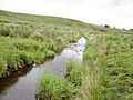
The Annick Water looking downstream from the bridge.

