
Lares barrio-pueblo facts for kids
Quick facts for kids
Lares barrio-pueblo
Pueblo de Lares
|
|
|---|---|
|
Municipality Seat
|
|

Church and monument at Plaza de la Revolución
|
|

Location of Lares barrio-pueblo within the municipality of Lares shown in red
|
|

Lares barrio-pueblo
Location in Caribbean
|
|
| Commonwealth | |
| Municipality | |
| Area | |
| • Total | 0.58 sq mi (1.5 km2) |
| • Land | 0.58 sq mi (1.5 km2) |
| • Water | 0 sq mi (0 km2) |
| Elevation | 1,109 ft (338 m) |
| Population
(2010)
|
|
| • Total | 2,690 |
| • Density | 4,637.9/sq mi (1,790.7/km2) |
| Source: 2010 Census | |
| Time zone | UTC−4 (AST) |
Lares barrio-pueblo is a special part of Lares, a town in Puerto Rico. It's like the main downtown area or the "heart" of the town. In 2010, about 2,690 people lived here.
In Puerto Rico, many towns have a central area called a pueblo. This area usually has a main square, the town hall, and a Catholic church. People gather in the main square for fun events and to socialize. Special festivals called Fiestas patronales are also held there every year.
Contents
The Central Plaza and Its Church
The main square in Lares Barrio Pueblo is called Plaza de la Revolución. This plaza is a lively spot for both official events and casual get-togethers. People can meet up and hang out there from morning until night.
Back in the early 1800s, Spanish laws called the Laws of the Indies guided how towns were built in Puerto Rico. These laws said that the plaza should be big enough for celebrations. They also suggested that nearby streets should have covered walkways. These walkways would protect people from the sun and rain.
Right across from the main plaza in Lares barrio-pueblo is the Parroquia San José. This is a Roman Catholic church. It was first built from wood and opened in 1838. Later, in 1881, it was rebuilt with stone walls. It had wooden towers and a wooden roof. The church was updated again in the 1920s. Today, the building looks quite different, but some of its original side walls and the first part of its front still remain.
History of Lares Barrio-Pueblo
After the Spanish–American War, Spain gave Puerto Rico to the United States. This happened under the Treaty of Paris of 1898. Puerto Rico then became a territory of the United States.
In 1899, the U.S. government took a count of the people in Puerto Rico. They found that 1,450 people lived in Lares Pueblo at that time. The population has changed over the years, as shown in the table below.
| Historical population | |||
|---|---|---|---|
| Census | Pop. | %± | |
| 1900 | 1,450 | — | |
| 1980 | 3,246 | — | |
| 1990 | 3,101 | −4.5% | |
| 2000 | 3,673 | 18.4% | |
| 2010 | 2,690 | −26.8% | |
| U.S. Decennial Census 1899 (shown as 1900) 1910-1930 1930-1950 1980-2000 2010 |
|||
Sectors of Lares Barrio-Pueblo
Barrios are like big neighborhoods or areas within a town. These barrios are then divided into smaller parts called sectores (which means "sectors" in English). These sectors are smaller local areas where people live.
The names of these sectors can be different. Some are just called "sector," while others might be named urbanización, reparto, barriada, or residencial. Each name describes a different type of living area.
Here are some of the sectors you can find in Lares barrio-pueblo:
Aurelio Bernal, Barriada Arizona, Barriada Bajadero, Barriada San Felipe, Barriada Viera, Calle Aldarondo, Calle Echegaray, Calle El Peligro, Calle Emilio Castro Rodríguez, Calle Ermita, Calle Felipe Arana, Calle Hospital, Calle La Gallera, Calle Molino, Calle Muñoz Rivera, Calle Palmer, Calle Rafael Castro, Calle Raúl Gándara, Calle San José, Sector Barranco, Calle San Pablo, Calle Sócrates González, Calle Vilella, Calle Villa Independencia, Calle Virgilio Acevedo, Camino González, Camino Henrry Arana, Carretera Acueducto, Cerro Márquez, Condominio Lares Gardens, Dr. Pedro Albizu Campos, Edificio Parques Platinos, Edificio Terrazas El Peligro, El Leñero, Ensanche González, Ensanche Sur, Extensión Altamira, Población, Ramal 111 Interior, Ramal 111 Interior (Emisora), Residencial Dr. Francisco Seín, Sector Desvío, Sector Guajataca, Sector Jardín de la Pasión, Sector Jayal, Sector Jobos, Sector La Monserrate, Sector La Sierra, Sector Los Torres, Sector Mercedes Estades, Sector Monte Bello, Sector Punta Brava, Tramo Carretera 124, Urbanización Altamira, Urbanización Buena Vista Calle Lecaroz, Urbanización Buena Vista, Urbanización Jardines de Lares, Urbanización Monte Bello, Urbanización Villa Borinquen, and Urbanización Villa Seral.
Gallery
-
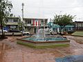
Fountain in Plaza de la Revolución
-
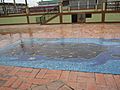
Map mosaic at Plaza de la Revolución
-
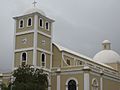
Catholic Church in Lares
-
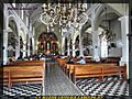
The church interior
-
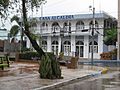
City Hall, 2019
-
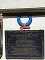
Plaque in Plaza de la Revolución
-
Ice cream shop Heladería El Grito owned by Jose Rodríguez Ruiz, mayor of Lares in 2020


See also
 In Spanish: Lares (Lares) para niños
- List of communities in Puerto Rico
- List of barrios and sectors of Lares, Puerto Rico
