
Lauderdale facts for kids

Lauderdale is a beautiful valley in the Scottish Borders. It follows the path of the Leader Water, which is a river that flows into the bigger Tweed. Inside Lauderdale, you'll find the town of Lauder and also Earlston. The main road, the A68 trunk road, goes right through the valley. This road connects Darlington in England to Edinburgh in Scotland.
Contents
Ancient Roman Road in Lauderdale
.jpg)
Lauderdale has many old camps and burial mounds called tumuli. These show that people lived here a very long time ago. The famous Roman road into Scotland, called Dere Street, passed through Lauderdale. Its name means "the road into the country of the wild animals."
The Roman road crossed the Tweed at Newstead, near Melrose. The Romans had a fort and soldiers stationed there. Later, King Malcolm Canmore might have fixed up Dere Street. He probably used it during his many battles against England. Today, you can still trace parts of this Roman road from the Tweed, through Lauderdale, all the way to Soutra.
What Does Lauderdale Mean?
The name Lauderdale comes from the town of Lauder. It does not come from the Leader Water river. It's a bit of a mystery how the names "Leader" and "Lauder" are connected. They sound similar but might have different origins. Some people think both names come from an old British word. This word might have meant "cleansing water." The name of the valley, Lauuedderdale, was first written down in the late 1100s.
Lauderdale's Medieval History
In the past, kings gave large areas of land to important people. King David I of Scotland created a special area called the Lordship of Regality of Lauderdale. He gave this land to Hugh de Morville around the year 1130. Hugh de Morville was a powerful Anglo-Norman noble and the Constable of Scotland. This meant he was in charge of the king's armies.
The land of Lauderdale changed hands many times. After Hugh de Morville, his family line ended. The Lordship then passed to Alan of Galloway through marriage. Later, it went to Alan's grandson, John Balliol, who became King of Scotland. When John Balliol lost his power, King Robert The Bruce gave Lauderdale to his loyal supporter, Sir James Douglas. The Douglas family held control for a long time. Eventually, they also lost their power over Lauderdale.
Towards the south of Lauderdale is the town of Earlston. This area was once controlled by the Earls of Dunbar. Records show that members of the Lauder family were important people in the area. They worked for the Earls of March during the time of King Robert the Bruce and King Robert III.
Lauderdale's Landscape and Nature

Lauderdale starts near Newstead in the south. In the north, it reaches the Lammermuir Hills. These hills are quite high, reaching over 1,700 feet. In winter, the weather there can be very bad, often closing roads. The valley is more than 10 miles long. Its width changes from three to seven miles.
A long time ago, until the 1600s, Lauderdale was a huge forest. It was a Royal hunting ground for kings like Malcolm Canmore. The area between the Leader and Gala Waters was covered by the Lauder forest. This forest belonged to the Lauder family for many centuries.
Today, Lauderdale is mostly farmland. You will see many fields used for growing crops and raising animals. The most important country house in the area is Thirlestane Castle. This castle has been the home of the Earl of Lauderdale since 1595. Horse riding events are held there every year. Lauderdale is part of the Scottish Borders Council region.
Images for kids
-
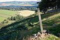
The Southern Upland Way entering Lauderdale
-
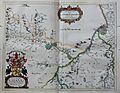
Map of Lauderdale from the Blaeu Atlas of Scotland (1654)
-
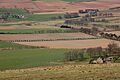
Fields in Lauderdale
