Scottish Borders facts for kids
Quick facts for kids
Scottish Borders
The Mairches (Scots) Crìochan na h-Alba (Scottish Gaelic) |
|
|---|---|
 |
|
| Sovereign state | United Kingdom |
| Country | Scotland |
| Lieutenancy areas | Berwickshire, Roxburgh, Ettrick and Lauderdale, Tweeddale |
| Admin HQ | Newtown St Boswells |
| Government | |
| • Body | Scottish Borders Council |
| Area | |
| • Total | 1,827 sq mi (4,732 km2) |
| Area rank | Ranked 6th |
| Population
(2020)
|
|
| • Total | 115,270 |
| • Rank | Ranked 18th |
| • Density | 63.091/sq mi (24.360/km2) |
| ONS code | S12000026 |
| ISO 3166 code | GB-SCB |
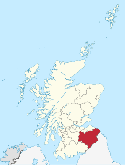
The Scottish Borders is one of 32 areas in Scotland run by a local council. It's often called "the Borders" or "the Marches." This area is in the southern part of Scotland.
It shares borders with several other areas. To the north, it's next to West Lothian, Edinburgh, Midlothian, and East Lothian. The North Sea is to its east. To the south-west, it borders Dumfries and Galloway. South Lanarkshire is to the west. Finally, to the south, it meets the English counties of Cumbria and Northumberland.
The biggest town in the Scottish Borders is Galashiels. The main office for the council is in Newtown St Boswells. The name "Scottish Borders" can also mean the wider area of southern Scotland and northern England that sits along the Anglo-Scottish border. This includes Dumfries and Galloway, Scottish Borders, Northumberland, and Cumbria.
The council area of the Scottish Borders covers roughly the same land as the old areas of Berwickshire, Peeblesshire, Roxburghshire, and Selkirkshire.
Contents
- History of the Scottish Borders
- Geography of the Scottish Borders
- Population of the Scottish Borders
- Language and Literature
- Transport in the Scottish Borders
- Media in the Scottish Borders
- Governance of the Scottish Borders
- Settlements in the Scottish Borders
- Places to Visit in the Scottish Borders
- See also
History of the Scottish Borders
The term "Borders" sometimes means a larger area. This includes all the counties in Scotland that touch the English border. It also includes parts of England like Northumberland, Cumberland, and Westmorland.
Battles and Border Reivers
Roxburghshire and Berwickshire were often at the center of fights with England. This happened during big wars like the Wars of Scottish Independence. It also happened during smaller armed raids by groups called the Border Reivers. These raids were a big problem for a long time.
There was even a special area called the "Debatable Land." This land was constantly fought over by England and Scotland. Its borders were finally set in 1552. Because of all these conflicts, you can see many ruined castles, abbeys, and even towns across the region.
Another important battle was the Battle of Philiphaugh in 1645. Here, the Marquess of Montrose was defeated during the time of the Covenanters. To protect themselves and control the moss-troopers (who were like bandits), castles were built on both sides of the border. These bandits were a threat until the late 1600s.
Early on, the rulers of both countries agreed to manage the borders. They set up the Scottish Marches system. Three wardens from each side were in charge. They usually kept the peace for several centuries. This system was later replaced by the Middle Shires under King James VI of Scotland and I of England.
How the Area Was Governed
Before 1975, the Scottish Borders area was split into four separate counties. These were Berwickshire, Peeblesshire, Roxburghshire, and Selkirkshire. Part of Midlothian was also included. Each county had its own elected council starting in 1890.
In 1975, these county councils were removed. A new system with two levels of local government was created. A larger area called "Borders" was formed. This region had four smaller districts: Berwickshire, Ettrick and Lauderdale, Roxburgh, and Tweeddale.
Then, in 1996, there was another change. The four districts and the regional council were all removed. A new single council was created for the same area. This new council was first called "The Borders." However, the council members chosen in 1995 decided to change the name to "Scottish Borders" before it officially started in 1996.
Geography of the Scottish Borders
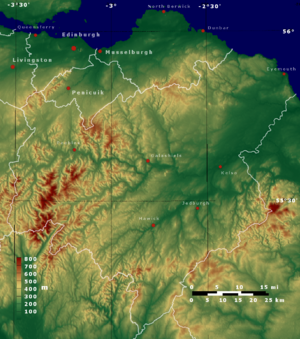
The Scottish Borders are located in the eastern part of the Southern Uplands. This area is mostly hilly and rural, meaning it has a lot of countryside. The River Tweed flows through the region from west to east.
The highest point in the region is Broad Law, which is part of the Manor Hills. In the eastern part of the region, the land near the River Tweed is flat. This flat area is known as 'The Merse'. The Tweed and its smaller rivers drain the entire region. The river flows into the North Sea at Berwick-upon-Tweed in Northumberland. For about the last twenty miles, the River Tweed forms the border with England.
Central Borders and Scenic Areas
The term Central Borders refers to the area where most of the main towns and villages are located. These include Galashiels, Selkirk, Hawick, Jedburgh, Earlston, Kelso, Newtown St Boswells, St Boswells, Peebles, Melrose, and Tweedbank.
Scotland has 40 national scenic areas. These are places with amazing scenery that are protected from too much building. Two of these special areas are in the Scottish Borders:
- The Eildon and Leaderfoot National Scenic Area covers the beautiful views around Eildon Hill. This hill is often called the Eildons because it has three 'peaks'. This area also includes the town of Melrose and the Leaderfoot Viaduct.
- The Upper Tweeddale National Scenic Area includes the lovely scenery around the upper part of the River Tweed. This stretches between Broughton and Peebles.
Population of the Scottish Borders
In the census held on March 27, 2011, the population of the Scottish Borders was 114,000 people. This was an increase of about 6.78% from the 106,764 people counted in the previous census in 2001.
Language and Literature
Long ago, some Scottish Gaelic was spoken here. You can see this in place names like Innerleithen and Kilbucho. These names have old Celtic words that show Gaelic was present, at least among some important people. However, since the 5th century, the main languages have been Brythonic (in the west) and Old English (in the east). Old English later became the English and Scots we know today.
Famous Border Ballads and Writers
Border ballads are a special type of poem or song from this area. Many of them tell stories of battles and adventures. Walter Scott helped save many of these ballads from being forgotten. He collected them in his book Minstrelsy of the Scottish Border, published in 1802 and 1803.
The traditions and exciting stories of the Borders also inspired other writers. These included James Hogg (known as "the Ettrick Shepherd") and John Wilson. Another writer, John Mackay Wilson, wrote Tales of the Borders in 1835. These stories were very popular throughout the 1800s.
Transport in the Scottish Borders

Until September 2015, the Scottish Borders had no active railway stations. In the past, during the Victorian times, the area had many train lines. However, most of these lines were closed after the Second World War.
A plan was approved by the Scottish Parliament to extend the Waverley Line. This aimed to bring back a train service for people traveling between Edinburgh and towns like Stow, Galashiels, and Tweedbank. This part of the railway re-opened on September 6, 2015, and is now called the Borders Railway.
The East Coast Main Line also runs through the region. The closest stations on this line are Edinburgh Waverley, Dunbar, and Berwick. These are just outside the Borders area. Since 2022, a railway link at Reston has re-opened within the region, serving Eyemouth. To the west, the nearest stations on the West Coast Main Line are Carlisle, Carstairs, and Lockerbie.
Buses connect the main towns and villages in the area. There are also express bus services that link the main towns to train stations in Edinburgh and Carlisle.
The region does not have any commercial airports. The closest international airports are Edinburgh and Newcastle.
Main Roads in the Region
The main roads that connect to and from the Scottish Borders are:
- The A1: This road runs along the east coast from London to Edinburgh. It passes close to Eyemouth.
- The A7: This road goes north to south from Edinburgh to Carlisle and the M6. It passes through Galashiels, Selkirk, and Hawick.
- The A68: This road runs from Darlington to Edinburgh. It passes through Jedburgh, St Boswells, Earlston, and Lauder.
- The A72: This road goes east to west from Galashiels to Hamilton. It passes through Innerleithen and Peebles.
Media in the Scottish Borders
For television, the Scottish Borders area receives broadcasts from BBC Scotland, which is based in Glasgow. It also gets signals from ITV Border, which broadcasts from Gateshead. Television signals come from the Selkirk TV transmitter.
Radio stations include BBC Radio Scotland. This station has a local opt-out from its studios in Selkirk. The commercial radio station, Radio Borders, broadcasts from Edinburgh. However, it still provides local news updates for the Scottish Borders area and for Berwick-upon Tweed in Northumberland.
The main local newspapers that serve the area are the Southern Reporter and The Border Telegraph.
Governance of the Scottish Borders
| Scottish Borders Council | |
|---|---|
 |
|
| Leadership | |
|
Convener
|
|
|
David Robertson
Since January 2023 |
|
| Structure | |
| Seats | 34 councillors |
 |
|
|
Political groups
|
|
| Elections | |
| Single transferable vote | |
|
Last election
|
5 May 2022 |
|
Next election
|
6 May 2027 |
| Meeting place | |
 |
|
| Council Headquarters, Bowden Road, Newtown St Boswells, Melrose, TD6 0SA | |
The Scottish Borders Council is the local government body for the area. It makes decisions about local services like schools, roads, and waste collection. The council has a Convener and a Leader who are in charge.
Council Leaders Over Time
After the changes in 1996, Drew Tulley was the first leader of the council. He had also been the last leader of the old Ettrick and Lauderdale District Council. Here are the leaders since 1996:
| Councillor | Party | From | To | |
|---|---|---|---|---|
| Drew Tulley | Independent | 1996 | 6 Mar 2002 | |
| John Ross Scott | Liberal Democrats | 6 Mar 2002 | 3 May 2003 | |
| David Parker | Independent | 12 Mar 2003 | 18 May 2017 | |
| Shona Haslam | Conservative | 18 May 2017 | 25 Nov 2021 | |
| Mark Rowley | Conservative | 25 Nov 2021 | 19 May 2022 | |
| Euan Jardine | Conservative | 19 May 2022 | ||
Council Headquarters
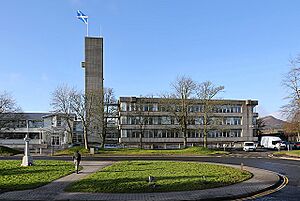
The Scottish Borders Council is based at the Council Headquarters in Newtown St Boswells. This building was once the main office for Roxburghshire County Council before 1975. Later, it served as the main office for the Borders Regional Council from 1975 to 1996.
Council Elections
Since 2007, elections for the council have been held every five years. They use a system called single transferable vote. This system was introduced by the Local Governance (Scotland) Act 2004. Here are the results of the elections since 1995:
| Year | Seats | Conservative | SNP | Liberal Democrats | Green | Labour | Independent / Other | Notes |
|---|---|---|---|---|---|---|---|---|
| 1995 | 58 | 3 | 8 | 15 | 0 | 2 | 30 | |
| 1999 | 34 | 1 | 4 | 14 | 0 | 1 | 14 | New ward boundaries |
| 2003 | 34 | 11 | 1 | 8 | 0 | 0 | 14 | |
| 2007 | 34 | 11 | 6 | 10 | 0 | 0 | 7 | New ward boundaries |
| 2012 | 34 | 10 | 9 | 6 | 0 | 0 | 9 | SNP / Lib Dem / Independent coalition |
| 2017 | 34 | 15 | 9 | 2 | 0 | 0 | 8 | Conservative / Independent coalition |
| 2022 | 34 | 14 | 9 | 3 | 1 | 0 | 7 | Conservative / Independent coalition |
Parliamentary Representatives
The Scottish Borders area has two constituencies for the British Parliament. Most of the region is covered by Berwickshire, Roxburgh and Selkirk. This area is represented by John Lamont from the Conservative party. The western part, Tweeddale, is in the Dumfriesshire, Clydesdale & Tweeddale constituency. This area is represented by David Mundell, also a Conservative.
At the Scottish Parliament level, there are also two seats. The eastern area is Ettrick, Roxburgh and Berwickshire. It is currently represented by Conservative Rachael Hamilton. The western area is Midlothian South, Tweeddale and Lauderdale. This area is represented by Christine Grahame from the SNP.
Council Wards
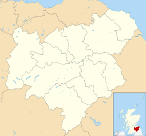
The Scottish Borders council area is divided into 11 smaller sections called wards. These wards elect a total of 34 councilors to represent the local people.
Settlements in the Scottish Borders
Here are the largest towns and villages in the Scottish Borders, listed by their population:
| Settlement | Population | |
|---|---|---|
| 2011 | (2020) | |
| Galashiels | 14,994 | 15490 |
| Hawick | 14,294 | 13620 |
| Peebles | 8,376 | 9000 |
| Kelso | 5,639 | 6870 |
| Selkirk | 5,784 | 4540 |
| Jedburgh | 4,030 | 3860 |
| Eyemouth | 3,546 | 3580 |
| Innerleithen | 3,031 | 3180 |
| Duns | 2,753 | 2820 |
| Melrose | 2,307 | 2500 |
Places to Visit in the Scottish Borders
- Abbotsford House
- Berwickshire Coastal Path
- Bowhill House
- Cheviot Hills
- Cessford Burn
- Coldingham Bay
- Dawyck Botanic Garden
- Dryburgh Abbey – Historic Scotland
- Duns Castle
- Edin's Hall Broch
- Ettrick Forest
- Eyemouth
- Floors Castle
- Glentress Forest – Forest Enterprise
- Greenknowe Tower
- Harmony Garden – National Trust for Scotland
- Hawkshaw – ancestral home of the Porteous family
- Hermitage Castle – Historic Scotland
- Jedburgh Abbey – Historic Scotland
- Kailzie Gardens
- Kelso Abbey
- Kirna House (The Kirna, previously Grangehill)
- Lammermuir Hills
- Lauderdale
- Manderston
- Megget Reservoir
- Mellerstain House
- Melrose Abbey – Historic Scotland
- Mire Loch
- Monteviot
- Morebattle
- Neidpath Castle
- Nisbet, Berwickshire
- Nisbet, Roxburghshire
- Paxton House
- Pennine Way – National Trails
- Priorwood Garden – National Trust for Scotland
- Robert Smail's Printing Works – National Trust for Scotland
- Scots' dike
- Smailholm Tower – Historic Scotland
- Southern Upland Way – National Trails
- St. Abbs Head
- St. Mary's Loch
- St. Ronans Wells
- Teviotdale
- Thirlestane Castle
- Traquair House
- Trimontium and the Eildons
- Union Bridge
- Waterloo Monument
- Wedderburn Castle
See also
 In Spanish: Scottish Borders para niños


