Berwickshire Coastal Path facts for kids
Quick facts for kids Berwickshire Coastal Path |
|
|---|---|

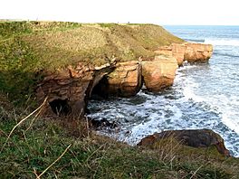
Cliffs seen from the path to the north of Berwick upon Tweed.
|
|
| Length | 48 km (30 mi) |
| Location | Berwickshire, Scotland and Northumberland, England |
| Designation | Scotland's Great Trails |
| Trailheads | Berwick upon Tweed55°46′16″N 2°00′25″W / 55.771°N 2.007°W Cockburnspath55°55′59″N 2°21′36″W / 55.933°N 2.360°W |
| Use | Hiking |
| Elevation gain/loss | 1,060 metres (3,480 ft) gain |
| Lowest point | Sea level |
| Hazards | High cliffs |
| Website | https://www.scotborders.gov.uk/berwickshirecoastalpath |
The Berwickshire Coastal Path is an exciting walking trail about 48 kilometers (30 miles) long. It follows the amazing eastern coast of Scotland. You can start your adventure in Cockburnspath in the Scottish Borders and walk all the way to Berwick upon Tweed, which is just across the border in England.
At Cockburnspath, this path connects with two other famous trails: the Southern Upland Way and the John Muir Way. This coastline is super important for seabirds, cool coastal plants (called flora), and amazing sea creatures. Much of it is a protected area. There's even a special nature reserve at St Abbs Head, looked after by the National Trust for Scotland.
You can walk the whole path in two days if you're a strong hiker. But it's also fun to split it into shorter parts. This gives you more time to explore the towns and villages along the way.
The path was created by the Scottish Borders Council. Now, NatureScot has named it one of Scotland's Great Trails. The route has special markers to guide you. You'll also see four statues at Eyemouth, Burnmouth, St Abbs, and Cove. These remember the 189 lives lost in the Eyemouth disaster on October 14, 1881. This was when a big storm hit the fishing fleet. Twelve bronze trail markers also link these memorial sculptures.
The Berwickshire Coastal Path connects with the Northumberland Coast Path at Berwick upon Tweed. This then links to the longer England Coast Path.
Contents
Exploring the Berwickshire Coastal Path
You can walk the path in different sections. Here's one way to do it in three stages.
Stage 1: Cockburnspath to Dowlaw
This first part of the path is a gentle start. You'll enjoy easy walking above Cove harbour. The path goes through farmland and some small roads. This stage is about 12 kilometers (7.5 miles) long.
Stage 2: Dowlaw to Eyemouth
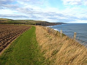
This stage begins gently through farmland. But soon, you'll reach the most dramatic part of the path! You'll walk along the edge of high cliffs, looking down at the sea. There will be some ups and downs as you go.
The path continues to the national nature reserve at St Abb's Head. This place is famous for its many seabirds. From there, you'll reach the fishing village of St Abbs. The path then follows the clifftops and beaches to arrive at the fishing port of Eyemouth. This section is about 17 kilometers (10.5 miles).
Stage 3: Eyemouth to Berwick-upon-Tweed
The final stage goes from Eyemouth to Berwick-upon-Tweed. Eyemouth was once a secret spot for smugglers! Today, it's mainly a busy fishing port and a great place for tourists. About 20 fishing boats call this port home. In summer, that number can even double.
The route follows the cliff tops. You'll cross the border into England at Marshall Meadows Bay. Then, you'll continue to Berwick-upon-Tweed in England. This final stage is about 19 kilometers (11.75 miles).
Cool Places to See Nearby
There are many interesting places close to the path. These include Pease Bay, Fast Castle, St Abbs Head, Coldingham, Eyemouth, Burnmouth, Gunsgreen House, and Berwick Upon Tweed.
 | William Lucy |
 | Charles Hayes |
 | Cleveland Robinson |


