
Marshall Meadows Bay facts for kids
Quick facts for kids Marshall Meadows Bay |
|
|---|---|
| Northernmost point of England | |

The Border on the East Coast Main Line
|
|
| Location | Northumberland, England, UK |
| OS grid | NT 9845 5689 |
| Coordinates | 55°48′40″N 2°02′03″W / 55.8111°N 2.0343°W |
Marshall Meadows Bay is the most northern point in England. It is found on the Northumberland coast. This bay is about 4 kilometers (2.5 miles) north of Berwick-upon-Tweed. It is also very close to the Anglo-Scottish border with Scotland.
Just across the border in Scotland is the area of Berwickshire. To the west of the bay is a small village called Marshall Meadows. This village is the most northern place in England where people live. You can find the Marshall Meadows Country House Hotel here. There is also a farm and a caravan site. A disused tunnel goes from the caravan site down to the bay. There are also two small caves nearby. The A1 main road and the East Coast Main Line railway are also close by.
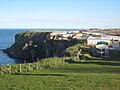
The Berwickshire Coastal Path is a walking trail that runs along the clifftop at Marshall Meadows Bay. The cliffs are about 50 meters (164 feet) high. A bus service called Borders Buses runs between Berwick and St Abbs. It stops at New East Farm, which is a short walk from Marshall Meadows Bay.
Contents
What is the Length of England?
The length of the English mainland is measured between two points. These are Marshall Meadows Bay in the north and Land's End in Cornwall. Land's End is the most southwestern point on the mainland. However, it is not the most southern point. That would be Lizard Point.
The distance between Marshall Meadows Bay and Land's End is about 895 kilometers (556 miles) by road. If you were to fly "as the crow flies" (in a straight line), it's about 686 kilometers (426 miles).
Challenges Across England
Walking or cycling the length of England is a popular challenge. People often do this to raise money for charity. A harder version is the Four Points Challenge. This involves walking to all four extreme points of England and returning to the start. Interestingly, Marshall Meadows Bay is closer to Stavanger in Norway than it is to Land's End.
How Did England's Northern Border Change?
The exact location of England's northernmost point has changed over time. This depended on where England's northern border was. The Kingdom of England began in the early 10th century. Its northern border was along the River Humber and River Ribble.
Early Border Changes
The Kingdom of Northumbria joined with Anglo-Saxon England in the mid-10th century. This pushed England's borders further north to the River Forth and Edinburgh. However, the area called Lothian was lost to the Scots in 1018 at the Battle of Carham. After this, Tweedmouth became England's northernmost point. The River Tweed then became the border.
The Border at Berwick-upon-Tweed
Control of Berwick-upon-Tweed switched between England and Scotland many times over the centuries. The English finally took the town back in 1482. The border we see today at Marshall Meadows Bay was set in the Treaty of Fotheringhay. This treaty was signed on June 11, 1482.
Images for kids
-
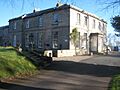
Marshall Meadows
Country House Hotel -
Caravan site above the bay
-
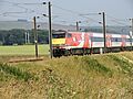
East Coast Main Line at
Marshall Meadows -
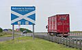
The Border on the A1
-
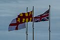
English Border flags on the A1


.jpg)
.jpg)
