
Burnmouth facts for kids
Quick facts for kids Burnmouth |
|
|---|---|
 Burnmouth Harbour |
|

Burnmouth
|
|
| OS grid reference | NT953608 |
| Civil parish | |
| Council area | |
| Lieutenancy area | |
| Country | Scotland |
| Sovereign state | United Kingdom |
| Post town | Eyemouth |
| Postcode district | TD14 |
| Police | Lothian and Borders |
| Fire | Lothian and Borders |
| Ambulance | Scottish |
| EU Parliament | Scotland |
| UK Parliament |
|
| Scottish Parliament | |
Burnmouth is a small and interesting fishing village located on the east coast of Scotland. It sits right next to the main A1 road. If you are driving from England into Scotland on the A1, Burnmouth is the very first village you will see! It is part of the Scottish Borders area and is governed by the Scottish Borders Council.
Contents
Discovering Burnmouth
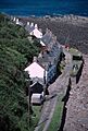
Burnmouth is special because it is built where a small stream, called a "burn," cuts through the tall cliffs along the coast. This burn then flows into the sea.
A Look at Burnmouth's Past
Long ago, there might have been a mill here in the Middle Ages. But the village really started to grow when a fishing harbour was built in the 1830s. This harbour was made bigger in 1879 and again in 1959 to help the fishing boats.
The East Coast Main Line railway, which is a big train track, runs along the top of the cliffs here. Burnmouth even had its own train station from 1846 to 1962. Today, you can enjoy walking along the Berwickshire Coastal Path nearby, which offers amazing views.
Exploring Burnmouth's Areas
Burnmouth is actually split into two main parts: Upper Burnmouth and Lower Burnmouth.

- Upper Burnmouth is located at the very top of the cliff.
- Lower Burnmouth is hidden away at the bottom of the cliff. It stretches out along the coastline.
Lower Burnmouth is further divided into four smaller areas: Lower Burnmouth, Partanhall, Cowdrait, and Ross.
- The main part of Lower Burnmouth is right next to the harbour.
- Partanhall is located to the north of the harbour.
- Cowdrait is found to the south of the harbour.
- The tiny community of Ross is just south of Cowdrait. Ross only has six houses today. It used to be considered a separate community because it is just across the parish border in Mordington.
Community Life in Burnmouth
Burnmouth has a small church that is located halfway down the "Brae." The Brae is the steep road that connects Lower Burnmouth to Upper Burnmouth.
Until 2005, the village had a small primary school where local children learned. Burnmouth also used to have two pubs, or inns, called The Flemington Inn and The Gulls Nest. The Gulls Nest is now known as the First and Last. These pubs were right next to each other by the A1 road. The Flemington Inn famously had signs saying "The last inn Scotland" and "The first inn Scotland" for drivers crossing the border. Sadly, The Flemington Inn was destroyed by a fire in 2006 and was later taken down.
Remembering the Eyemouth Disaster

In 1881, Burnmouth faced a terrible event known as the Eyemouth disaster. During this disaster, 24 fishermen from the village tragically drowned. To remember these brave men, there is a special bronze plaque on the harbour wall.
The Brae Race
Every May, Burnmouth hosts an exciting annual bike race called the "Brae Race." The race takes place on the very steep road that goes up the cliff from Lower Burnmouth to Upper Burnmouth. It is a challenging and fun event for the community!
Images for kids
-
Partanhall, seen from the church on the hill.

