kids encyclopedia robot

Laurel Valley Sugar Plantation facts for kids

Kids Encyclopedia Facts
Quick facts for kids
Laurel Valley Sugar Plantation
Ruined mill at the Laurel Valley Sugar Plantation.jpg
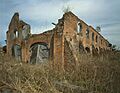
Ruined mill at the plantation
Laurel Valley Sugar Plantation is located in Louisiana
Laurel Valley Sugar Plantation
Location in Louisiana
Laurel Valley Sugar Plantation is located in the United States
Laurel Valley Sugar Plantation
Location in the United States
Location Along Laurel Valley Road, about 2.3 miles (3.7 km) east of Thibodaux
Nearest city Thibodaux, Louisiana
Area 1,230 acres (500 ha)
Built 1850
Architectural style American Renaissance, Queen Anne Revival
NRHP reference No. 78001426
Added to NRHP March 24, 1978

Laurel Valley Sugar Plantation is located in Thibodaux, Louisiana. It is listed on the National Register of Historic Places.

History

The plantation was owned by Joseph Tucker, a Virginian, who bought more than 50,000 acres of land along Bayou Lafourche. The earliest structures on the property date to the 1830s. It was at one time the largest producer of sugar in Lafourche Parish, and a mill was built on the property for this purpose.

As many as 135 slaves lived and worked on the property prior to the Civil War. While the main house built by Tucker was destroyed during the Civil War, shotgun houses (slave quarters) and Creole cabins remain on the property. The mill stopped production in the 1930s, and sustained significant damage during Hurricane Betsy in 1965. It is named after where it is located.

Laurel Valley today

With over fifty original structures remaining it is the largest surviving 19th- and 20th-century sugar plantation complex left in the United States and is still a working sugarcane farm. The general store on the property is open to the public, displaying tools and farm implements used in the cultivation of sugar cane as well as locally made arts and crafts. The store wasn't originally at the plantation, it had to be moved there. Its proprietor was Leon Z. Boudreaux.

Laurel Valley Plantation was added as a historic district to the National Register of Historic Places on March 24, 1978.

Contributing properties

The historic 1,230 acres (500 ha) district comprises about 80 buildings and structures dating from c.1850 to c.1910:

Along LA 308

  • Plantation Church, also known as Old Fountain Missionary Baptist Church, 29°47′11″N 90°47′01″W / 29.78633°N 90.78352°W / 29.78633; -90.78352 (Plantation Church), comprises the adjacent cemetery.
  • Double Creole House #1, 29°47′15″N 90°47′04″W / 29.78759°N 90.78452°W / 29.78759; -90.78452 (Double Creole House #1), built c.1890.
  • Double Creole House #2, 29°47′21″N 90°47′11″W / 29.7893°N 90.7864°W / 29.7893; -90.7864 (Double Creole House #2), built c.1890.
  • Plantation Store, 29°47′24″N 90°47′12″W / 29.78995°N 90.78671°W / 29.78995; -90.78671 (Plantation Store), built c.1890.
  • Double Creole House #3, 29°47′25″N 90°47′13″W / 29.79033°N 90.78683°W / 29.79033; -90.78683 (Double Creole House #3), built c.1890.
  • Creole House #1, 29°47′25″N 90°47′14″W / 29.79016°N 90.78732°W / 29.79016; -90.78732 (Creole House #1), built c.1900.
  • Creole House #2, 29°47′26″N 90°47′15″W / 29.79043°N 90.78741°W / 29.79043; -90.78741 (Creole House #2), built c.1910.
  • Shotgun House #1, 29°47′27″N 90°47′14″W / 29.79076°N 90.78723°W / 29.79076; -90.78723 (Shotgun House #1), built c.1890.

Main House Complex

  • Plantation House, 29°48′33″N 90°46′16″W / 29.80926°N 90.77123°W / 29.80926; -90.77123 (Plantation House), built c.1880.
  • Servants' Quarters, 29°48′32″N 90°46′16″W / 29.80899°N 90.77101°W / 29.80899; -90.77101 (Servants' Quarters), built c.1880.

Single family Creole houses area

  • Double Creole House #4, 29°48′37″N 90°46′19″W / 29.81018°N 90.77184°W / 29.81018; -90.77184 (Double Creole House #4). No more standing.
  • School House, 29°48′38″N 90°46′19″W / 29.81059°N 90.77196°W / 29.81059; -90.77196 (School House). No more standing.
  • Shotgun House #2, 29°48′41″N 90°46′17″W / 29.81146°N 90.77144°W / 29.81146; -90.77144 (Shotgun House #2), built c.1910.
  • Creole House #3, 29°48′43″N 90°46′16″W / 29.81187°N 90.77111°W / 29.81187; -90.77111 (Creole House #3), built c.1880.
  • Creole House #4, 29°48′44″N 90°46′15″W / 29.81217°N 90.77087°W / 29.81217; -90.77087 (Creole House #4), built c.1880.
  • Creole House #5, 29°48′45″N 90°46′14″W / 29.81246°N 90.77063°W / 29.81246; -90.77063 (Creole House #5), built c.1880.
  • Creole House #6, 29°48′46″N 90°46′13″W / 29.81276°N 90.77039°W / 29.81276; -90.77039 (Creole House #6), built c.1880.
  • Creole House #7, 29°48′47″N 90°46′13″W / 29.81305°N 90.77015°W / 29.81305; -90.77015 (Creole House #7), built c.1880.
  • Telephone Booth, 29°48′48″N 90°46′13″W / 29.81334°N 90.77022°W / 29.81334; -90.77022 (Telephone Booth). No more standing.
  • Weighing Station, 29°48′47″N 90°46′11″W / 29.81313°N 90.76981°W / 29.81313; -90.76981 (Weighing Station), built c.1910.
  • Plantation Foreman House, 29°48′46″N 90°46′09″W / 29.81267°N 90.76911°W / 29.81267; -90.76911 (Plantation Foreman House), built c.1900.

Creole double houses area

  • Watchman/Overseer's House, 29°48′40″N 90°46′22″W / 29.81106°N 90.77268°W / 29.81106; -90.77268 (Watchman/Overseer's House), built c.1900.
  • Double Creole Tenant House #1, 29°48′41″N 90°46′21″W / 29.81125°N 90.77255°W / 29.81125; -90.77255 (Double Creole Tenant House #1), built c.1880.
  • Double Creole Tenant House #2, 29°48′41″N 90°46′21″W / 29.81141°N 90.77242°W / 29.81141; -90.77242 (Double Creole Tenant House #2), built c.1880.
  • Double Creole Tenant House #3, 29°48′42″N 90°46′20″W / 29.81158°N 90.77228°W / 29.81158; -90.77228 (Double Creole Tenant House #3), built c.1880.
  • Double Creole Tenant House #4, 29°48′42″N 90°46′20″W / 29.81175°N 90.77215°W / 29.81175; -90.77215 (Double Creole Tenant House #4), built c.1880.
  • Double Creole Tenant House #5, 29°48′43″N 90°46′19″W / 29.81192°N 90.77201°W / 29.81192; -90.77201 (Double Creole Tenant House #5), built c.1880.
  • Double Creole Tenant House #6, 29°48′44″N 90°46′19″W / 29.81209°N 90.77187°W / 29.81209; -90.77187 (Double Creole Tenant House #6), built c.1880.
  • Double Creole Tenant House #7, 29°48′44″N 90°46′18″W / 29.81225°N 90.77173°W / 29.81225; -90.77173 (Double Creole Tenant House #7), built c.1880.
  • Double Creole Tenant House #8, 29°48′45″N 90°46′18″W / 29.81243°N 90.77158°W / 29.81243; -90.77158 (Double Creole Tenant House #8), built c.1880.
  • Double Creole Tenant House #9, 29°48′45″N 90°46′17″W / 29.8126°N 90.77145°W / 29.8126; -90.77145 (Double Creole Tenant House #9), built c.1880.
  • Double Creole Tenant House #10, 29°48′46″N 90°46′17″W / 29.81277°N 90.77131°W / 29.81277; -90.77131 (Double Creole Tenant House #10), built c.1880.
  • Creole Tenant House #1, 29°48′47″N 90°46′16″W / 29.81294°N 90.77118°W / 29.81294; -90.77118 (Creole Tenant House #1), built c.1880.
  • Office/Carriage House, 29°48′47″N 90°46′16″W / 29.81306°N 90.77102°W / 29.81306; -90.77102 (Office/Carriage House), built c.1880.
  • Shop, 29°48′47″N 90°46′15″W / 29.81316°N 90.77089°W / 29.81316; -90.77089 (Shop), built c.1880.

Production Complex and Shotgun houses

  • Single Tenant House #1, 29°48′42″N 90°46′24″W / 29.81155°N 90.77347°W / 29.81155; -90.77347 (Single Tenant House #1), built c.1884.
  • Single Tenant House #2, 29°48′42″N 90°46′24″W / 29.81172°N 90.77333°W / 29.81172; -90.77333 (Single Tenant House #2), built c.1884.
  • Single Tenant House #3, 29°48′43″N 90°46′24″W / 29.8119°N 90.77321°W / 29.8119; -90.77321 (Single Tenant House #3), built c.1884.
  • Single Tenant House #4, 29°48′44″N 90°46′23″W / 29.8121°N 90.77305°W / 29.8121; -90.77305 (Single Tenant House #4), built c.1884.
  • Single Tenant House #5, 29°48′48″N 90°46′20″W / 29.81327°N 90.77215°W / 29.81327; -90.77215 (Single Tenant House #5), built c.1884.
  • Single Tenant House #6, 29°48′48″N 90°46′19″W / 29.81344°N 90.77202°W / 29.81344; -90.77202 (Single Tenant House #6), built c.1884.
  • Multiple Tenant House/Storage Shed, 29°48′42″N 90°46′21″W / 29.81177°N 90.77259°W / 29.81177; -90.77259 (Multiple Tenant House/Storage Shed), built c.1900. No more standing.
  • Single Tenant Shotgun House #1, 29°48′43″N 90°46′22″W / 29.81188°N 90.77274°W / 29.81188; -90.77274 (Single Tenant Shotgun House #1), built c.1900.
  • Single Tenant Shotgun House #2, 29°48′43″N 90°46′20″W / 29.81201°N 90.77233°W / 29.81201; -90.77233 (Single Tenant Shotgun House #2), built c.1900.
  • Single Tenant Shotgun House #3, 29°48′44″N 90°46′21″W / 29.81214°N 90.77254°W / 29.81214; -90.77254 (Single Tenant Shotgun House #3), built c.1900.
  • Single Tenant Shotgun House #4, 29°48′44″N 90°46′22″W / 29.81226°N 90.77276°W / 29.81226; -90.77276 (Single Tenant Shotgun House #4), built c.1900.
  • Single Tenant Shotgun House #5, 29°48′45″N 90°46′23″W / 29.81242°N 90.77302°W / 29.81242; -90.77302 (Single Tenant Shotgun House #5), built c.1900.
  • Single Tenant Shotgun House #6, 29°48′45″N 90°46′24″W / 29.81259°N 90.77331°W / 29.81259; -90.77331 (Single Tenant Shotgun House #6), built c.1900.
  • Single Tenant Shotgun House #7, 29°48′46″N 90°46′25″W / 29.81274°N 90.77358°W / 29.81274; -90.77358 (Single Tenant Shotgun House #7), built c.1900.
  • Single Tenant Shotgun House #8, 29°48′44″N 90°46′20″W / 29.81221°N 90.77218°W / 29.81221; -90.77218 (Single Tenant Shotgun House #8), built c.1900.
  • Single Tenant Shotgun House #9, 29°48′44″N 90°46′21″W / 29.81233°N 90.77238°W / 29.81233; -90.77238 (Single Tenant Shotgun House #9), built c.1900.
  • Single Tenant Shotgun House #10, 29°48′45″N 90°46′21″W / 29.81244°N 90.77259°W / 29.81244; -90.77259 (Single Tenant Shotgun House #10), built c.1900.
  • Single Tenant Shotgun House #11, 29°48′45″N 90°46′22″W / 29.81261°N 90.77287°W / 29.81261; -90.77287 (Single Tenant Shotgun House #11), built c.1900.
  • Single Tenant Shotgun House #12, 29°48′46″N 90°46′23″W / 29.81279°N 90.77314°W / 29.81279; -90.77314 (Single Tenant Shotgun House #12), built c.1900.
  • Single Tenant Shotgun House #13, 29°48′47″N 90°46′24″W / 29.81295°N 90.77343°W / 29.81295; -90.77343 (Single Tenant Shotgun House #13), built c.1900.
  • Single Tenant Shotgun House #14, 29°48′45″N 90°46′19″W / 29.81247°N 90.77197°W / 29.81247; -90.77197 (Single Tenant Shotgun House #14), built c.1900.
  • Single Tenant Shotgun House #15, 29°48′45″N 90°46′20″W / 29.81259°N 90.77218°W / 29.81259; -90.77218 (Single Tenant Shotgun House #15), built c.1900.
  • Single Tenant Shotgun House #16, 29°48′46″N 90°46′21″W / 29.81272°N 90.77238°W / 29.81272; -90.77238 (Single Tenant Shotgun House #16), built c.1900.
  • Single Tenant Shotgun House #17, 29°48′46″N 90°46′22″W / 29.81288°N 90.77266°W / 29.81288; -90.77266 (Single Tenant Shotgun House #17), built c.1900.
  • Single Tenant Shotgun House #18, 29°48′47″N 90°46′23″W / 29.81305°N 90.77294°W / 29.81305; -90.77294 (Single Tenant Shotgun House #18), built c.1900.
  • Single Tenant Shotgun House #19, 29°48′47″N 90°46′24″W / 29.81319°N 90.77321°W / 29.81319; -90.77321 (Single Tenant Shotgun House #19), built c.1900.
  • Single Tenant Shotgun House #20, 29°48′46″N 90°46′19″W / 29.8128°N 90.77204°W / 29.8128; -90.77204 (Single Tenant Shotgun House #20), built c.1900.
  • Single Tenant Shotgun House #21, 29°48′46″N 90°46′20″W / 29.81291°N 90.77223°W / 29.81291; -90.77223 (Single Tenant Shotgun House #21), built c.1900.
  • Single Tenant Shotgun House #22, 29°48′47″N 90°46′21″W / 29.81307°N 90.77251°W / 29.81307; -90.77251 (Single Tenant Shotgun House #22), built c.1900.
  • Single Tenant Shotgun House #23, 29°48′48″N 90°46′22″W / 29.81324°N 90.77281°W / 29.81324; -90.77281 (Single Tenant Shotgun House #23), built c.1900.
  • Single Tenant Shotgun House #24, 29°48′48″N 90°46′23″W / 29.8134°N 90.77308°W / 29.8134; -90.77308 (Single Tenant Shotgun House #24), built c.1900.
  • Single Tenant Shotgun House #25, 29°48′49″N 90°46′21″W / 29.81354°N 90.77259°W / 29.81354; -90.77259 (Single Tenant Shotgun House #25), built c.1900.
  • Loading Crane, 29°48′48″N 90°46′15″W / 29.81339°N 90.77084°W / 29.81339; -90.77084 (Loading Crane).
  • Sugar Mill, 29°48′49″N 90°46′17″W / 29.81363°N 90.77135°W / 29.81363; -90.77135 (Sugar Mill), built c.1850.
  • Exhaust Stack, 29°48′51″N 90°46′16″W / 29.81412°N 90.77102°W / 29.81412; -90.77102 (Exhaust Stack), built c.1850.
  • Boarding House, 29°48′50″N 90°46′17″W / 29.81401°N 90.77149°W / 29.81401; -90.77149 (Boarding House), built c.1900.
  • Grinding Mill Pump Station, 29°48′53″N 90°46′17″W / 29.81471°N 90.77147°W / 29.81471; -90.77147 (Grinding Mill Pump Station).
  • Corn Shed Barn, 29°48′53″N 90°46′15″W / 29.81477°N 90.77083°W / 29.81477; -90.77083 (Corn Shed Barn), built c.1880.
  • Shed, 29°48′53″N 90°46′15″W / 29.81459°N 90.77076°W / 29.81459; -90.77076 (Shed).
  • Pump House, 29°48′50″N 90°46′13″W / 29.81397°N 90.77032°W / 29.81397; -90.77032 (Pump House).
  • Creole Tenant House #2, 29°48′49″N 90°46′12″W / 29.81372°N 90.77003°W / 29.81372; -90.77003 (Creole Tenant House #2), built c.1890.
  • Weigh Station, 29°48′49″N 90°46′12″W / 29.8136°N 90.77012°W / 29.8136; -90.77012 (Weigh Station), built c.1890.
kids search engine
Laurel Valley Sugar Plantation Facts for Kids. Kiddle Encyclopedia.