Lebanon, Nebraska facts for kids
Quick facts for kids
Lebanon, Nebraska
|
|
|---|---|
|
Village
|
|

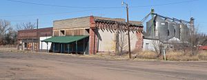
Downtown Lebanon, March 2011
|
|

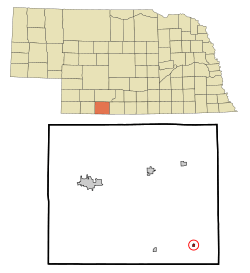
Location of Lebanon, Nebraska
|
|
| Country | United States |
| State | Nebraska |
| County | Red Willow |
| Area | |
| • Total | 0.16 sq mi (0.42 km2) |
| • Land | 0.16 sq mi (0.42 km2) |
| • Water | 0.00 sq mi (0.00 km2) |
| Elevation | 2,408 ft (734 m) |
| Population
(2020)
|
|
| • Total | 46 |
| • Density | 285.71/sq mi (110.44/km2) |
| Time zone | UTC-6 (Central (CST)) |
| • Summer (DST) | UTC-5 (CDT) |
| ZIP code |
69036
|
| Area code(s) | 308 |
| FIPS code | 31-26455 |
| GNIS feature ID | 2398409 |
Lebanon is a small village located in Red Willow County, Nebraska, in the United States. According to the 2020 census, about 46 people live there.
Contents
History of Lebanon
Lebanon was officially planned and mapped out in 1887. This happened when the Burlington & Missouri River Railroad built its tracks to this area. The village was named after the famous Cedars of Lebanon, which are large, ancient trees.
In April 1955, a special event took place. Charles Harris, a representative from Lebanon, Nebraska, was part of a group of 40 mayors from American cities also named "Lebanon." They were invited to visit the country of Lebanon in the Middle East. The mayor of Lebanon, Nebraska, at the time was Chester Keith, but he was too old to travel.
During their trip, while visiting Jerusalem, which was then divided, Charles Harris accidentally crossed a border. Sadly, he was killed in an accident involving a Jordanian soldier. This sad event became a big international news story. The United Nations even started an investigation to find out what happened.
Geography of the Village
Lebanon is a small village in terms of its size. The United States Census Bureau reports that the village covers about 0.16 square miles (0.42 square kilometers). All of this area is land, with no water.
Population and People
The number of people living in Lebanon has changed over the years. Here is a look at the population from different census reports:
| Historical population | |||
|---|---|---|---|
| Census | Pop. | %± | |
| 1910 | 197 | — | |
| 1920 | 245 | 24.4% | |
| 1930 | 262 | 6.9% | |
| 1940 | 238 | −9.2% | |
| 1950 | 213 | −10.5% | |
| 1960 | 143 | −32.9% | |
| 1970 | 118 | −17.5% | |
| 1980 | 102 | −13.6% | |
| 1990 | 75 | −26.5% | |
| 2000 | 70 | −6.7% | |
| 2010 | 80 | 14.3% | |
| 2020 | 46 | −42.5% | |
| U.S. Decennial Census | |||
Lebanon Population in 2010
In 2010, the village had 80 people living in it. There were 33 households and 21 families. This means there were about 500 people for every square mile (193 people per square kilometer).
Most of the people living in Lebanon in 2010 were White.
- About 36% of households had children under 18 living with them.
- More than half (51.5%) of households were married couples living together.
- About 27% of all households were made up of people living alone.
- About 9% of households had someone aged 65 or older living by themselves.
The average age of people in the village was 36.5 years old.
- About 26% of residents were under 18 years old.
- About 11% were between 18 and 24 years old.
- About 20% were between 25 and 44 years old.
- About 31% were between 45 and 64 years old.
- About 11% were 65 years or older.
More males lived in the village than females. About 56% of the population was male, and 44% was female.
See also
 In Spanish: Lebanon (Nebraska) para niños

