Leetsdale, Pennsylvania facts for kids
Quick facts for kids
Leetsdale, Pennsylvania
|
|
|---|---|
|
Borough
|
|

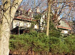
Elmridge, a historic site in the borough
|
|

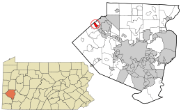
Location in Allegheny County and the state of Pennsylvania.
|
|
| Country | United States |
| State | Pennsylvania |
| County | Allegheny |
| Incorporated | March 28, 1904 |
| Area | |
| • Total | 1.20 sq mi (3.10 km2) |
| • Land | 1.00 sq mi (2.59 km2) |
| • Water | 0.20 sq mi (0.51 km2) |
| Population
(2020)
|
|
| • Total | 1,162 |
| • Density | 1,163.16/sq mi (448.89/km2) |
| Time zone | UTC-5 (Eastern (EST)) |
| • Summer (DST) | UTC-4 (EDT) |
| ZIP code |
15056
|
| FIPS code | 42-42392 |
Leetsdale is a small town, called a borough, in Allegheny County, Pennsylvania, USA. It's right next to the Ohio River and is part of the bigger Pittsburgh area. In 2020, about 1,162 people lived there.
Contents
Discovering Leetsdale's Past
Leetsdale officially became a borough on March 28, 1904. Long ago, Leetsdale had many factories. A big steel factory, Bethlehem Steel, was here, but it closed in the late 1970s.
Now, where the steel factory used to be, there's a place called the Leetsdale Industrial Park. It's also known as the Port of Leetsdale. Many different companies rent spaces here. This area used to be a brownfield, which means it was land that was once used for industry and might have had pollution. But in the 1990s, it was cleaned up. Today, only a few of the original factory buildings are still standing. In 2022, two companies, CGI Steel and Nextracker, fixed up an old steel factory. They now use it to make equipment for solar trackers, which help solar panels follow the sun.
Leetsdale is also home to a special old house called Elmridge. It's also known as the James Gardiner Coffin/John Walker house. This house is so important that it's listed on the National Register of Historic Places.
Leetsdale's Location and Landscape
Leetsdale is located at 40°34′0″N 80°12′41″W / 40.56667°N 80.21139°W.
The United States Census Bureau says that Leetsdale covers a total area of about 1.1 square miles. Most of this area, about 1.0 square mile, is land. The rest, about 0.2 square miles, is water. This means about 13.91% of Leetsdale's total area is water.
Neighboring Communities
Leetsdale shares its borders with several other towns. To the north, it's next to Ambridge in Beaver County. To the northeast, you'll find Leet Township. To the southeast, it borders Edgeworth.
The borough also includes a place that used to be a town called Shields. The Ohio River forms the southwestern edge of Leetsdale. If you look across the river, you'll see Crescent Township.
Leetsdale's Population Over Time
| Historical population | |||
|---|---|---|---|
| Census | Pop. | %± | |
| 1910 | 1,904 | — | |
| 1920 | 2,311 | 21.4% | |
| 1930 | 2,774 | 20.0% | |
| 1940 | 2,332 | −15.9% | |
| 1950 | 2,411 | 3.4% | |
| 1960 | 2,153 | −10.7% | |
| 1970 | 1,862 | −13.5% | |
| 1980 | 1,604 | −13.9% | |
| 1990 | 1,387 | −13.5% | |
| 2000 | 1,337 | −3.6% | |
| 2010 | 1,218 | −8.9% | |
| 2020 | 1,162 | −4.6% | |
| Sources: | |||
In the year 2000, there were 1,232 people living in Leetsdale. These people lived in 586 households, and 370 of those were families. The population was spread out, with about 1,246 people living in each square mile. There were also 653 housing units, meaning places where people could live.
Most people in Leetsdale were White (89.20%). About 7.31% were African American. A small number were from other races (0.65%) or from two or more races (2.84%). About 1.62% of the population was Hispanic or Latino.
Out of the 586 households, about 23.6% had children under 18 living there. About 41.7% were married couples living together. About 14.1% had a female head of household with no husband present. And 40.8% were not families. About 38.0% of all households had only one person living there. About 21.4% of households had someone aged 65 or older living alone. On average, there were 2.14 people per household and 2.80 people per family.
The median age in the borough was 43 years old. This means half the people were younger than 43 and half were older. About 21.3% of the population was under 18. About 22.8% were 65 or older.
The median income for a household in Leetsdale was $28,672. For families, the median income was $37,500. The average income per person in the borough was $19,172. About 9.6% of families and 12.8% of all people lived below the poverty line. This included 22.1% of those under 18 and 10.2% of those 65 or older.
See also
 In Spanish: Leetsdale para niños
 | Sharif Bey |
 | Hale Woodruff |
 | Richmond Barthé |
 | Purvis Young |

