Legible London facts for kids
Legible London is a special system in London that helps people find their way around. It's run by Transport for London (TfL). This system uses clear signs and maps all over the city. It helps both visitors and people who live there easily understand where they are and how to get where they want to go. It's the biggest wayfinding system of its kind in the world!
Besides the signs on the streets, you can also find Legible London maps in all London Underground (Tube) stations. They are also in Docklands Light Railway stations and on bus stops. You'll even see them at Santander Cycles bike docking stations and along the Cycle Superhighways bike paths.
Contents
How Legible London Signs Look
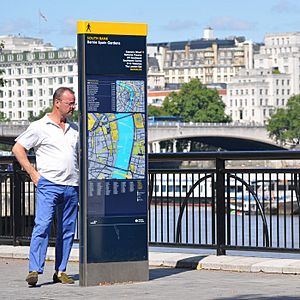
The Legible London system uses three main sizes of signs. These are called the "Monolith," "Midilith," and "Minilith." They are made from strong materials like special glass and metal. This makes them tough and long-lasting.
Each sign has a bright yellow stripe at the top. This stripe has a little picture of a person walking. This bright color helps you spot the signs easily, even from far away in the busy city.
Understanding the Maps
Most Legible London signs show two different maps. One is a "planner map" and the other is a "finder map." They are usually on opposite sides of the sign. Sometimes, if there isn't much space, a sign might only have one map.
Both maps show "walking circles." These circles help you understand how far you can walk. The planner map shows a circle for a 15-minute walk. This is about 1.125 kilometers (or 0.7 miles). The finder map shows a circle for a 5-minute walk. This is about 375 meters (or 0.2 miles). These distances are based on how fast an average person walks.
The maps show buildings and landmarks in a special way. They look 2D, but important buildings are shown in 3D. This helps you recognize places around you more easily. Also, the maps are always turned to face the direction you are looking. This means the top of the map is the direction you are facing, not always north. This makes it much simpler to follow.
TfL is also working on new digital signs. These would have a regular map on one side. The other side would have an interactive screen you can touch.
Why Legible London Started
In 2004, the Mayor of London at the time, Ken Livingstone, wanted London to be a city where people could easily walk everywhere by 2015. People realized that London needed a better way to help walkers.
There were many different types of signs in central London. Over 30 different systems were being used by various local groups. This made it confusing for people trying to find their way. It also made the city look messy. This confusion made people feel unsure when walking around.
People also found that many Tube (subway) journeys were actually quicker to walk. But visitors didn't know this! This caused the Tube to get very crowded. Also, many people used the Tube map to find their way even when walking. This happened because they didn't know the local area well.
Testing the Idea
To see if the idea would work, studies were done in different parts of London. These included Westminster, South Bank, Richmond, and Twickenham. This showed how the system could work in different areas.
A first test of the signs was set up around Oxford Street and Bond Street. There were 19 signs with new maps. People liked them a lot! Because this test was so successful, TfL decided to develop the system further.
More pilot projects were set up in Westminster/Camden, South Bank, and Richmond and Twickenham. These helped test the signs even more. They checked how the maps worked and what information was best to include. After these tests, a survey showed that people really supported the new system.
Legible London Outside London
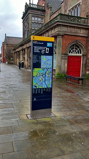
The Legible London system has been so successful that other places have started using similar ideas. For example, signs like the Legible London monoliths are now used on streets and canals in Stoke-on-Trent.
Awards Legible London Has Won
- Gold Medal, Design for Society section, Design Business Association Design Effectiveness Awards, 2008
- Ordnance Survey MasterMap Award for Better Mapping, British Cartographic Society, 2009
- Honor Award, Society for Experiential Graphic Design, 2010
 | Charles R. Drew |
 | Benjamin Banneker |
 | Jane C. Wright |
 | Roger Arliner Young |


