
Leslie Street Spit facts for kids

The Leslie Street Spit, officially called the Outer Harbour East Headland, is a unique piece of land in Toronto, Ontario, Canada. It was built by people, extending about 5 kilometers (3 miles) into Lake Ontario. This land was created over 50 years by the Toronto Port Authority. It was first planned to expand Toronto's harbour for ships. However, it has since become a popular spot for outdoor activities and nature. Even though it wasn't planned, nature has taken over much of the area. The Toronto Region Conservation Authority now actively manages this natural growth. A large part of the Spit is a special Environmentally Sensitive Area and an Important Bird Area.
Most people in Toronto call it the "Leslie Street Spit." This name comes from Leslie Street, which runs along the peninsula. The official name, Outer Harbour East Headland, is rarely used.
Contents
A Man-Made Landform: How the Spit Was Built

The Leslie Street Spit is a man-made landform. Its construction began in the 1950s. The Toronto Harbour Commission started building it as a breakwater. A breakwater is a barrier that protects a harbour from strong waves. This project was part of a bigger plan to make Toronto's harbour larger. They expected more ships after the Saint Lawrence Seaway opened in 1959.
However, shipping changed a lot in the 1960s. Cargo began to be packed into large containers, and ships started using East Coast ports more. This meant fewer cargo ships came to Toronto. So, the big outer harbour was no longer needed. Today, all cargo ships still use the Inner Harbour, and the Outer Harbour is mostly for pleasure boats.
Even though the original reason for the Spit changed, it kept growing. It became a place to dump extra soil and construction waste. This came from building Toronto's subways, office towers, and other big projects. In the late 1970s, muddy material from the nearby Keating Channel was also added. This was seen as a better solution than dumping it into the open lake. Even now, PortsToronto continues to add silt and mud to the Spit's bays.
In the early 1970s, the Spit was one of many landfill parks planned for Toronto's shoreline. The Toronto and Region Conservation Authority (TRCA) managed this. It started as a long, thin strip of bare land. Over time, it grew into several sections with small bays. Plants and trees began to grow, turning it into a green space.
Structure and Access

The inner part of the Spit has three large bays, called embayments. These bays were made to hold material that was dredged (scooped out) from the Inner Harbour and Keating Channel. The first bay is now full. It has been covered with clean soil and is being turned into a marsh by the TRCA. The other two bays still have space for about 50 more years of material. The Outer Harbour lies between the Port Lands and the Spit. This area was once part of a marsh near Ashbridge's Bay.
In the early 1980s, a strong barrier called an endikement was built on the eastern side of the bays. This endikement acts like a rigid breakwater. It protects the bays and helps to keep sediment from the Inner Harbour away.
Visiting the Spit
In the past, it was hard to visit the Spit. By the summer of 1974, the Toronto Harbour Commission started offering bus service on Sunday afternoons.
Today, the Spit is open to the public during specific hours. On weekends and holidays (except Christmas, Boxing Day, and New Year's Day), it is open from 5:30 a.m. to 9:00 p.m. On weekdays, it is open from 4:00 p.m. to 9:00 p.m. It is closed during the day on weekdays because construction work is still happening.
The Leslie Street Spit is a car-free area when the park is open. Only special vehicles are allowed for work. The very end of the Spit is called Vicki Keith Point, named after a famous Canadian swimmer. A lighthouse has been there since 1974.
Tommy Thompson Park
The northern half of the Spit is known as Tommy Thompson Park. It is named after a former Toronto Parks Commissioner. The TRCA manages this parkland. The southern half is still an active area for dumping materials, managed by PortsToronto. Eventually, the entire Spit will become parkland for everyone to enjoy.
.jpg)
An Important Bird Area

The Leslie Street Spit is a very important place for birds. More than 300 different kinds of birds have been seen there. About 45 of these species even build their nests and raise their young on the Spit. Some common birds you might see include the ring-billed gull, the black-crowned night-heron, the double-crested cormorant, the common tern, the Caspian tern, and the herring gull.
Because so many bird species rely on the Leslie Street Spit, it has been named an Important Bird Area (IBA). This special title is given by Nature Canada and Bird Studies Canada. These groups are Canadian partners of BirdLife International. Peninsula D on the Spit is also home to a bird research station. The Tommy Thompson Park Bird Research Station works seven days a week during spring and fall when birds are migrating. They also do other projects in the Toronto area throughout the year. Visitors are welcome at the station on weekends when the park is open.
Images for kids
-
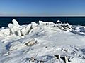
Rubble and other human-made artifacts covered by winter ice at the Leslie Spit.
-

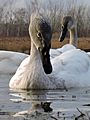
Swans, ducks, and other birds basking in the sun at the Leslie Spit in winter.
-

The Leslie Spit in late spring looking across the Main Harbour Channel towards the Toronto skyline.
-

Looking towards downtown Toronto from the Leslie Spit in autumn.
-
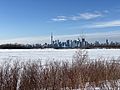
The Leslie Spit in winter looking towards downtown Toronto.
-

View of the setting sun from the Leslie Spit in winter
-

Northern Sawhet Owl
-

Warbler singing
-
Curious young swan
-

Dominant male coyote
-

Sawhet Owl
-

Moss-covered dragonfly
_in_winter.jpg)
.jpg)

_in_Autumn.jpg)
.jpg)
_in_the_winter.jpg)


