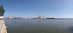
Keating Channel facts for kids
Quick facts for kids Keating Channel |
|
|---|---|
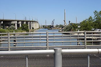
Channel, looking east from Cherry St. The channel ends about 5 m behind the camera's viewpoint, the Don River entering in the far background.
|
|
|
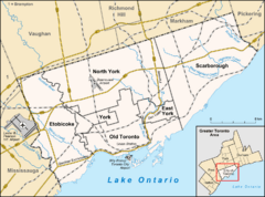
Location of the mouth of Keating Channel in Toronto
|
|
| Country | Canada |
| Province | Ontario |
| Municipality | Toronto |
| Physical characteristics | |
| Main source | Don River 74 m (243 ft) 43°39′05″N 79°20′52″W / 43.65139°N 79.34778°W |
| River mouth | Toronto Harbour Toronto 74 m (243 ft) 43°38′46″N 79°21′27″W / 43.64611°N 79.35750°W |
| Length | 1 km (0.62 mi) |
| Basin features | |
| River system | Great Lakes Basin |
The Keating Channel is a 1,000-metre (3,300 ft) long waterway in Toronto, Ontario, Canada. It connects the Don River to inner Toronto Harbour (Toronto Bay) on Lake Ontario. The channel is named after Edward Henry Keating (1844-1912), a city engineer (1892-1898) who proposed creating the channel in 1893. The channel was built to connect Ashbridge's Bay to the harbour. Later, the Don River was moved to flow into the channel, and its old river mouth was filled in during the early 1910s.
Contents
History of the Keating Channel
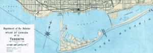
Before the 1800s, the Don River naturally flowed into Toronto Harbour through two openings. One was near where the Keating Channel is now, and another was further south. In the late 1800s, a big public project began. It aimed to make the lower part of the Don River straighter, south of the Winchester Street Bridge. This project was called the "Don Improvement Project."
Why the Channel Was Built
The main goal of the project was to stop floods on the lower Don River. These floods often washed away bridges. It also aimed to create more space for ships to dock in Toronto Harbour. When the project was finished, the river was directed south into Ashbridge's Bay.
At that time, Ashbridge's Bay was a lake-like marsh. It was very polluted by nearby factories. People hoped that directing the river water into the bay would clean it. However, the river water carried raw sewage into the bay. The bay water stayed dirty and became a serious health risk. The Keating Channel was then suggested as a way to send the dirty river water directly into the harbour. This would help spread it out more quickly.
Building the Channel
The channel was planned to go from the northeast corner of the inner harbour east towards Leslie Street. It was supposed to connect with the Coatsworth Cut. However, the part east of the Don River was never finished and was closed in 1916. The main channel was completed in 1922 after eight years of construction. The finished channel now runs from the harbour east to the mouth of the river, covering about 800 meters.
The Don River's original mouth is now buried under land near where the Gardiner Expressway meets Cherry Street. The river's old path upstream is now under railway tracks used by GO Transit for storing trains.
Channel Surroundings
The north side of the channel is next to the raised Gardiner Expressway and Lake Shore Boulevard East. The south side has the PortsToronto (also known as Toronto Port Authority) work yard and the Keating Channel Pub. At the west end, Cherry Street crosses the channel over a drawbridge. This bridge can open for ships but is rarely used. At the east end is the start of the Don Valley Parkway.
Dealing with Silt
In the 1940s, the area around the Don River further upstream became more developed with buildings. This caused more silt (fine dirt and sand) to flow down the river. The silt collects in the channel because the water flows very slowly there. Since then, the Toronto and Region Conservation Authority (TRCA) has been dredging the channel. Dredging means removing the silt from the bottom. The removed material is taken by barge to the Leslie Street Spit. There, it is dumped into a special area built for this purpose. In 2005, about 35,000 cubic meters of silt were dredged each year. The storage area can hold 50 years' worth of Don River silt.
Industry Along the Channel
In 1896, Canada's government asked for bids to build a railway swing bridge over the channel. Construction on this bridge began in 1900.
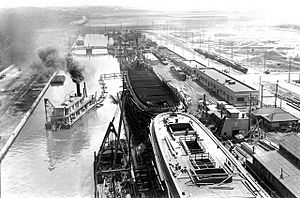
Early in its history, the banks of the channel were home to many factories and businesses. This included a small shipyard, the Toronto Shipyard Company. This company built ships to help with the war effort during World War One.
The channel has always been dredged to keep it deep enough for boats to pass. In the 21st century, the channel is no longer a major cargo route. It is now dredged to a depth of 5.8 metres (19 ft). The Toronto harbour master, Angus Armstrong, explained that current dredging efforts are done for "whatever is needed for the health of the river."
Current Issues Affecting the Channel
The Keating Channel has different effects on the Don River. Both sides of the channel have concrete walls. These walls create a barrier and offer very little natural home for fish and other water creatures. The Don River is home to about 21 types of fish. However, only about four or five types can be found near the channel's mouth. This is partly because the water quality is not good and also because there isn't much natural habitat. The concrete walls continue, mostly without breaks, north to Riverdale Park. This is different from the Humber River to the west, which has a natural mouth and is home to about 44 fish species.
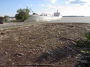
Another problem for the channel is floating garbage and natural debris that washes down the Don River. This includes many logs and dead wood, along with various types of trash. The TRCA uses a floating barrier (a boom) across the channel to collect this material. A lot of floating debris can gather where the Keating Channel enters Toronto Harbour, especially after a big storm.
Restoration Initiatives
On the north side of the channel, a slight curve in Lake Shore Boulevard created a narrow open space. In 1998, the Task Force to Bring Back the Don planted different types of trees and shrubs in this area. These included Staghorn Sumac (Rhus typhina), Sandbar Willow (Salix exigua), and Red Osier Dogwood (Cornus stolonifera). Even though the soil was poor, the willow and the tough sumac have grown well. It is now a long, narrow area with small trees and shrubs.
Another small green space at the eastern end was also planned for restoration. However, this project was stopped after only one planting. There was also an idea to remove part of the concrete wall to create better homes for fish. These projects were put on hold because a much larger project was expected to start soon.
Plans for a Natural River Mouth
In 1999, the three levels of government announced plans to improve Toronto's waterfront. One of the first four projects was a plan to make the mouth of the Don River more natural.
In 2005, an environmental study began to look at ways to restore the Don River's original mouth. Some ideas being considered would fill in the Keating Channel. They would then direct the Don River through a new channel just north of Lake Shore Boulevard. Another idea was to send it straight south to connect with or cut through the inner basin shipping channel south of the Keating Channel. The environmental study process is still ongoing.
People who support making the Don River's mouth more natural say that this restoration would help protect against damage from rare floods. This includes floods with water flow equal to or greater than the one from Hurricane Hazel in 1954.
Villiers Island Project
In 2018, the western end of the Keating Channel started to be made narrower. This is part of building Villiers Island. Villiers Island will have the Keating Channel as its northern edge. The Polson slip will be made more natural, and its channel will be extended to the Don River.
 | Emma Amos |
 | Edward Mitchell Bannister |
 | Larry D. Alexander |
 | Ernie Barnes |


