Humber River (Ontario) facts for kids
Quick facts for kids Humber River |
|
|---|---|
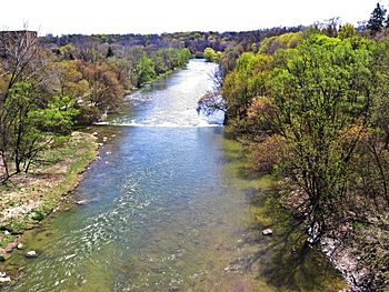
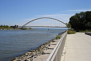
The Humber River in Toronto
|
|
|
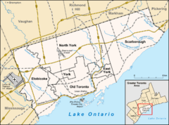
Location of the mouth of the Humber River in Toronto
|
|
| Country | Canada |
| Province | Ontario |
| Region | Southern Ontario |
| Census divisions |
|
| Municipalities | |
| Physical characteristics | |
| Main source | Humber Springs Ponds Mono, Dufferin County 421 m (1,381 ft) 43°56′36″N 80°00′14″W / 43.94333°N 80.00389°W |
| River mouth | Humber Bay, Lake Ontario Toronto 74 m (243 ft) 43°37′56″N 79°28′19″W / 43.63222°N 79.47194°W |
| Length | 100 km (62 mi) |
| Basin features | |
| River system | Great Lakes Basin |
| Basin size | 903 km2 (349 sq mi) |
The Humber River is a river in Southern Ontario, Canada. It is part of the Great Lakes Basin. The river flows into Lake Ontario. It is one of two main rivers in Toronto, with the other being the Don River to the east. The Humber River was named a Canadian Heritage River on September 24, 1999.
The Humber River gets its water from about 750 smaller creeks and streams. These are located in a wide area north of Toronto. This area includes parts of Dufferin County, Peel, Simcoe County, and York. The main part of the river is about 100 kilometers (62 miles) long. It starts at the Niagara Escarpment in the northwest.
Another important branch, called the East Humber River, begins at Lake St. George. This lake is in the Oak Ridges Moraine near Aurora. The two main branches meet north of Toronto. From there, they flow southeast into Lake Ontario. The river's mouth is located where Humber Bay Park East and Sir Casimir Gzowski Park are today.
Contents
What's in a Name? The Humber River's History
The Humber River has two names from Indigenous peoples. One name is "Cobechenonk." This means "leave the canoes and go back." It was used by the Anishinaabe people. Another name is "Niwa’ah Onega’gaih’ih," which means "Little Thundering Waters."
An old French map from 1688 called the river "passage de taronto." Later, a map from 1733 showed it as the "Tanaovate River." This was next to a native village called Tejajagon. Lieutenant-Governor John Graves Simcoe later named it the Humber River. He likely named it after the Humber estuary in England.
A Look Back: Humber River's Past
The Humber River has a long history of people living along its banks. We know about early native settlements from archaeological findings. There were three main groups of settlers. The first were the Palaeo-Indians, who lived here from 10,000 to 7000 BC.
The second group, from the Archaic period (7000 to 1000 BC), started moving with the seasons. They did this to find plants, fish, and game. The third group was from the Woodland period. During this time, people started using the bow and arrow. They also began growing crops, which allowed for larger, more permanent villages.
The Toronto Carrying-Place Trail
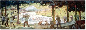
During the Woodland period, native groups often traveled along the Toronto Carrying-Place Trail. This important path went from Lake Ontario, up the Humber River, to Lake Simcoe. From there, it led to the northern Great Lakes.
It is thought that Étienne Brûlé was the first European to see the Humber River. He traveled the Toronto Carrying-Place Trail in 1615. Brûlé was on a mission from Samuel de Champlain to make friends with native peoples. However, he did not write down his experiences. The Trail became a quick way for traders, explorers, and missionaries to reach the upper Great Lakes.
A key spot at the northern end of the trail in Lake Simcoe gave the whole trail its name. Eventually, the southern end became known as "Toronto" to Europeans. In the 1660s, the Seneca had a trading village called Teiaiagon here. Popple's map from 1733 shows a large river next to "Tejajagon," which is believed to be the Humber.
European Trading Posts and Forts
In the late 1600s and 1700s, French traders often used the portage along the Humber River. It was a shortcut to the upper Great Lakes and areas north of Toronto. To protect this trade route from the British, the French built Magasin Royal. This trading post was near Baby Point and finished in 1720. But it was soon left empty after the British built a fort in Oswego, New York. This new fort took away trade from Magasin Royal.
In 1750, the French built another fort near the Humber River's mouth. They wanted to stop Indigenous people from trading with the British at Fort Oswego. This new fort, called Fort Toronto, was very successful. It had more demand for goods than it could supply. Because of its success, the Governor General of New France, the Marquis de la Jonquière, ordered a bigger fort to be built.
This new fort, Fort Rouillé, was finished in 1751. It was located where Exhibition Place is today. The fort operated until 1759, during the Seven Years' War. The soldiers were told to leave and destroy the fort if Fort Niagara was captured. After they were defeated at Fort Niagara in July 1759, they left for Montreal.
British Control and Early Settlement
British forces took control of the area in September 1760. Robert Rogers, a British scout, led 200 men to take over the former French fort. In 1772, Jean-Bonaventure Rousseau got a license to trade with the First Nations near the Humber River's mouth. His son, Jean Baptiste Rousseau, took over the license in 1774.
Jean Baptiste Rousseau had many contacts in the area. He moved there permanently in 1792 and set up a trading post near the river's mouth. In 1793, Rousseau guided John Graves Simcoe's ship into Toronto Bay. This officially started the settlement of York. Most British attention was on the east side of the Humber, closer to the Don River.
Settlement was spread out until after the War of 1812. Many loyalists moved to the area, along with immigrants from Ireland and Scotland.
Mills and Flooding
When Simcoe arrived in York, he knew the area needed mills for lumber and grain. In 1793, he built a sawmill on the west bank of the river near where Bloor Street is now. John Wilson ran this mill. In 1797, Simcoe helped set up a grist mill (for grinding grain) on the Humber River. John Lawrence owned and ran it.
Over the years, many mills operated along the river. Some owners included William Cooper, W. P. Howland, Thomas Fisher, John Scarlett, William Gamble, and Joseph Rowntree. The last grist mill on the Humber, Hayhoe Mills in Woodbridge, closed in 2007.
By 1860, many trees in the Humber Valley had been cut down. This made the river banks less stable and increased flood damage. In 1878, a huge flood destroyed the remaining water-powered mills. As Toronto grew, the land around the Humber became important for farming. Also, some areas of the river's flood plain were developed for homes. This led to serious water runoff problems in the 1940s.
The Humber Valley Conservation Authority was created to fix these problems. But in 1954, Hurricane Hazel caused the river to flood terribly. It destroyed buildings and bridges. On Raymore Drive, 60 homes were destroyed, and 35 people died.
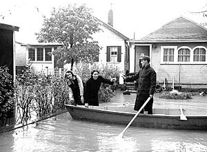
The Metropolitan Toronto and Region Conservation Authority (MTRCA) took over from the Humber Valley authority in 1957. Later, the word "Metropolitan" was removed in 1998. More recently, a special group within the Authority worked to clean up the Humber. This was part of the Great Lakes 2000 Cleanup Fund.
Exploring the Humber River's Geography
The Humber River starts at Humber Springs Ponds. These ponds are on the Niagara Escarpment in Mono, Dufferin County. The river flows until it reaches Humber Bay on Lake Ontario in Toronto. The West Humber River flows through the Claireville Conservation Area. It joins the east branch at Summerlea Park.
Humber River Watershed
The Humber watershed is a natural area in south-central Ontario, Canada. It mainly covers north and west Toronto. It covers an area of 903 square kilometers (349 square miles). The river flows through different land types, including the Oak Ridges Moraine and the Niagara Escarpment.
The Humber watershed is bordered by other river watersheds. To the west are the Credit River, Etobicoke Creek, and Mimico Creek watersheds. To the east are the Garrison Creek, Don River, and Rouge River watersheds. All these rivers flow into Lake Ontario. To the north is the Nottawasaga River, which flows into Lake Huron. To the northeast is the Holland River, which flows into Lake Simcoe.
Unlike the Don River to the east, the Humber River stayed mostly free from factories as Toronto grew. After the big flood from Hurricane Hazel, much of the land around the Humber became parkland. The important wetlands at its southern end were left untouched. The mouth of the Don River often gets blocked by floating debris and low bridges. But the Humber is easy to travel on and is used for fun activities like boating and fishing.
Today, most of the Humber River in Toronto is parkland. Paved trails run from the lake shore all the way to the city's northern border, about 30 kilometers (19 miles) away. Trails along the different branches of the river make up about 50 kilometers (31 miles) of bicycling trails. Most of these trails are in good condition. The trails along the Don River are usually narrower and not as well kept. However, all the trails are connected along the lake shore, creating about 100 kilometers (62 miles) of paved off-road trails.
Humber River's Tributaries
Here are some of the smaller streams and creeks that flow into the Humber River:
- Albion Creek: This creek flows southwest from east of Bolton. It joins the West Humber from the north. It is about 9 kilometers (5.6 miles) long.
- Berry Creek: This creek starts near Martin Grove Road. It flows southeast to meet the main Humber River. It is about 3.8 kilometers (2.4 miles) long.
- Black Creek: This creek starts north of Toronto in Vaughan. It flows south to meet the lower Humber River.
- Centreville Creek
- East Humber: This branch flows from north of Toronto. It meets the main Humber River in Woodbridge, just north of Highway 7. Its watershed goes east to Yonge Street and north to King City. Its source is Wilcox Lake.
- Emery Creek: This creek flows south from its source west of Finch Avenue. It meets the main Humber River. It is about 2.4 kilometers (1.5 miles) long.
- Humber Creek: This creek runs southeast from its source near Islington Avenue. It flows through neighborhoods and meets the lower Humber River. It is about 3.8 kilometers (2.4 miles) long.
- King Creek: This creek is a tributary of the East Humber. It flows south to meet the East Humber south of King Road.
- Purpleville Creek
- Rainbow Creek
- Salt Creek
- Silver Creek: This creek runs southwesterly from its source near Eglinton Avenue. It flows through a golf course and neighborhoods. It meets the lower Humber River. It is about 2 kilometers (1.2 miles) long.
- West Humber: This branch meets the main Humber River east of Albion Road. The West Humber itself has several branches coming from northwest of Toronto.
Source: Toronto and Region Conservation Authority, The Atlas of Canada.
See also
 In Spanish: Río Humber (Ontario) para niños
 | Ernest Everett Just |
 | Mary Jackson |
 | Emmett Chappelle |
 | Marie Maynard Daly |


