
Etobicoke Creek facts for kids
Quick facts for kids Etobicoke Creek |
|
|---|---|

Looking north up Etobicoke Creek from Lake Shore Boulevard
|
|

Location of the mouth of the creek in Toronto
|
|
| Country | Canada |
| Province | Ontario |
| Region | Greater Toronto Area |
| Municipalities |
|
| Physical characteristics | |
| Main source | Caledon, Regional Municipality of Peel 300 m (980 ft) 43°47′19″N 79°53′39″W / 43.78861°N 79.89417°W |
| River mouth | Lake Ontario Marie Curtis Park, Toronto 74 m (243 ft) 43°35′05″N 79°32′28″W / 43.58472°N 79.54111°W |
| Length | 61 km (38 mi) |
| Basin features | |
| Basin size | 211 km2 (81 sq mi) |
| Tributaries |
|
Etobicoke Creek is a river in the Greater Toronto Area of Ontario, Canada. It flows into Lake Ontario. The creek starts in Caledon and ends in southern Etobicoke, which is part of the City of Toronto. The Toronto and Region Conservation Authority helps manage and protect this important waterway.
Contents
What's in a Name? The Story of Etobicoke Creek
The name "Etobicoke" comes from the Mississaugas, an Indigenous group. Their word wah-do-be-kang (or wadoopikaang) means "place where the alders grow." This name was used to describe the land between Etobicoke Creek and the Humber River.
How the Name Changed Over Time
In 1775, the creek was sometimes called "Tobacock." Later, in 1795, Lieutenant Governor John Graves Simcoe officially named the area "Etobicoke." He also referred to it as "Smith River or Etobicoke" in 1796.
For many years, people used both "creek" and "river" to describe the waterway. However, in 1962, the Geographical Names Board of Canada officially decided on "Creek."
Where Does Etobicoke Creek Flow?


Etobicoke Creek starts south of the Oak Ridges Moraine, a large ridge of hills. It then flows through the towns of Caledon, Brampton, and Mississauga. The creek passes west of the Toronto Pearson International Airport.
Its journey ends when it flows into Lake Ontario in the Etobicoke part of Toronto. The entire creek is about 61 kilometers (38 miles) long.
The Etobicoke Creek Watershed
A watershed is an area of land where all the water drains into a single river or creek. The Etobicoke Creek watershed covers about 211 square kilometers (81 square miles).
A Natural Boundary
The southern part of the creek forms a natural border. It separates Toronto on the east side from Mississauga (in Peel Region) on the west side. This boundary goes as far north as Eglinton Avenue.
Water Quality and Wildlife
The creek flows into Marie Curtis Park, a large park where people can relax. The creek bed is made of solid stone, often covered with smaller rocks. You can find small fish and crayfish in the water. Finding these creatures is a good sign that the water is clean and healthy.
Geology and Landscape
The Etobicoke Creek is known for its winding paths and deep ravines. Its banks are often made of shale, a type of rock that splits into thin layers.
Neighbourhoods Along the Creek
Several neighbourhoods in Toronto are located right next to Etobicoke Creek:
- Markland Wood is bordered by Etobicoke Creek to the west.
- Alderwood has Etobicoke Creek as its western boundary.
- Long Branch is also bordered on the west by Etobicoke Creek.
Smaller Streams Joining the Creek
Etobicoke Creek has smaller streams, called tributaries, that flow into it:
- Spring Creek starts northwest of the airport and flows north before joining Etobicoke Creek.
- Little Etobicoke Creek is another tributary.
- Elmcrest Creek is a small stream that begins from two ponds in Etobicoke Centennial Park. It flows south and joins Etobicoke Creek near the Markland Wood Golf Club.
Gallery
-
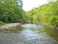
The Etobicoke Creek looking north from the waterfall
-
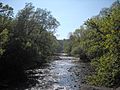
The Etobicoke Creek as it travels south
-
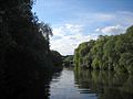
The Etobicoke Creek as it travels through Marie Curtis Park
-
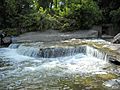
The waterfall in the Etobicoke Creek near the south end of the creek. It is located beside the Toronto Golf Course.
-
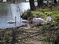
Four mute swans along the bank of the Etobicoke Creek.


Images for kids
-
The burnt-out fuselage of Air France Flight 358 after overrunning runway 24L at Toronto Pearson International Airport.
