Teiaiagon facts for kids
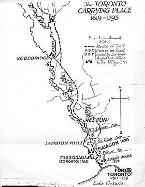
Teiaiagon was an old village built by the Iroquoian people. It was located on the east side of the Humber River in what is now Toronto, Ontario, Canada. The village was an important stop along the Toronto Carrying-Place Trail, a path used for travel and trade. Today, the area is near Jane Street and Annette Street, in a community called Baby Point. The name Teiaiagon means "It crosses the stream."
Contents
History of Teiaiagon Village
Teiaiagon was home to different First Nations groups over time. Records show it was a shared village for the Seneca and Mohawk people. Later, around 1696, it became a village for the Mississauga people. The village existed even before these dates.
Early Visitors and Trade
In 1615, Étienne Brûlé, an early European explorer, passed through Teiaiagon. The village was on a very important route for the growing fur trade. This was a time when people traded animal furs, like beaver pelts, for European goods. The village was also surrounded by fields where people grew crops. It was said to be about a day's journey from "Toronto Lake," which we now call Lake Simcoe.
La Salle's Visits to Teiaiagon
On November 18, 1678, a famous explorer named René-Robert Cavelier, Sieur de La Salle left Fort Frontenac. He was heading to Niagara by boat. A storm forced his crew to stop at the mouth of the Humber River on November 26. The people of Teiaiagon were friendly and gave them food. On December 5, the ship left after the crew used axes to break it free from the ice. Before leaving, La Salle's men traded their goods with the villagers for corn.
A missionary named Louis Hennepin and others wrote that Teiaiagon was a large village. It had as many as 5,000 people and 50 long houses. Longhouses were large, shared homes where many families lived together. La Salle camped at Teiaiagon several other times during his trips, including in 1680 and possibly twice in 1681. There was also a burial ground about 10 acres (40,000 square meters) in the middle of the village.
Changes in the Village
The Seneca people left Teiaiagon by 1701. They either moved away or were replaced by the Mississauga people. After the Great Peace of Montreal in 1701, trade between the Anishinaabe people (which includes the Mississaugas) and the French grew in the area.
From 1720 to 1730, a small French military post or store was near Teiaiagon. In 1730, this French post moved further down the river. Later, in 1750, a store was built at the mouth of the Humber River. Soon after, Fort Rouillé was built to the east of the Humber.
The Mississaugas did not live exactly where Teiaiagon was. They had a village across the Humber River, on the west bank, from 1788 to 1805. In 1816, James Bâby bought the land now called Baby Point. He only had orchards on the old Teiaiagon site, so the area was mostly left alone. The government later bought the Teiaiagon area for a military fort. However, it was then sold to Robert Home Smith, who started building homes there in 1912. In 1949, a plaque was put up at Baby Point, briefly mentioning "Taiaiagon."
Mapping Teiaiagon
Early European explorers often found it hard to write down First Nations names. This is why Teiaiagon has many different spellings. Some of these include Taiaiako'n, Taiaiagon, Teyeyagon, and Toioiugon.
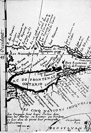
The name "Teiaigon" appears on a map of New France from 1688. This map was drawn by Jean-Baptiste-Louis Franquelin. It showed Teiaigon on the east side of a small bay. From there, a portage route (a path where boats were carried over land) led to a branch of Lake Taronto.
Archeology at Teiaiagon
Archeology is the study of human history through digging up old sites and artifacts. The first digs at Baby Point happened in the late 1800s. The records from these early digs are lost, but we know they found "traces of palisade walls." Palisade walls were strong fences made of logs, often used to protect villages.
In the late 1990s and early 2000s, new digs took place. These happened because a natural gas line was being installed in the neighborhood. Archeologists found the burial sites of two Seneca women. These burials were from the 1680s. One woman was buried with a comb made from a moose antler. It had a carving of a panther with a rattlesnake tail, possibly showing Mishipizheu, a powerful spirit. The other woman was buried with three brass rings and another carved moose antler comb. This comb showed two human figures in European-style clothes next to an Aboriginal figure.
Another burial site was found at Baby Point in 2010 when a house was being fixed up. The artifacts found were studied, and a special reburial ceremony took place.
Just north of the site, in Magwood Park, there is a place called "Thunderbird Mound." People believe this is an ancient burial mound. However, it has not been studied by archeologists yet. The Taiaiako'n Historical Preservation Society is worried that this site is being damaged by erosion and people walking on it.
Iroquois Villages on Lake Ontario's North Shore
By the late 1660s, different groups of the Five Nation Iroquois had built seven villages along the shores of Lake Ontario. These villages were located where trails led into the land. Besides Teiaiagon at the mouth of the Humber River, historian Percy James Robinson has identified these other settlements:
- Ganneious - where Napanee is today
- Kente - on the Bay of Quinte
- Kentsio - on Rice Lake
- Ganaraske - where Port Hope is today
- Ganatsekwyagon - at the mouth of the Rouge River
- Quinaouatoua (or Tinawatawa) - near modern-day Hamilton
 | James Van Der Zee |
 | Alma Thomas |
 | Ellis Wilson |
 | Margaret Taylor-Burroughs |


