Bead Hill facts for kids
|
Ganatsekwyagon (Seneca)
|
|

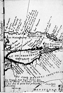
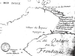
Late 1600s map of Lac de Frontenac (Lake Ontario), showing Ganatsekwyagon (Ganatchekiagon) and Lac Taronto, and the land occupied by the Mississaugas and the Iroquois
|
|
| Location | Toronto, Ontario, Canada |
|---|---|
| History | |
| Periods | 17th century |
| Cultures | Iroquois |
| Site notes | |
| Public access | No |
| Official name: Bead Hill National Historic Site of Canada | |
| Designated: | 1991 |
Bead Hill is a very special archaeological site in Canada. It's the only known 17th-century site of the Seneca people that is still mostly untouched. You can find it along the Rouge River in Rouge Park, which is a national park in Toronto, Ontario. Because it's so important and fragile, the site isn't open to visitors. It became a National Historic Site of Canada in 1991. Later, in 2019, it became part of Canada's national park system.
Contents
What is Bead Hill?
The Bead Hill site is thought to be one of seven villages. These villages were built by the Iroquois people along the north shore of Lake Ontario in the 1660s. The Iroquois Confederacy moved north from their homeland in New York state. They settled Bead Hill for a short time during this move.
Before the Iroquois, the Huron-Wendat Confederacy lived along Lake Ontario's north shores. But they moved north towards Georgian Bay and Lake Simcoe by the end of the 1500s.
Discovering the Bead Hill Site
Experts did a lot of digging and research in the 1980s. They found that Bead Hill might be the historic village known as Ganatsekwyagon. Tests show that about 500 to 800 people lived here. They likely stayed for about 22 years, from 1665 to 1687.
Bead Hill was mainly a place for trading furs. It was not a military fort or a farming village. Its location was perfect for trade. It was near important routes like the lakeshore trail, which is now Kingston Road. It was also close to the historic Toronto Carrying-Place Trail. Bead Hill is right next to Glen Rouge Park and Campgrounds.
Ganatsekwyagon: The Historic Village
The Bead Hill site is believed to hold the remains of the village of Ganatsekwyagon. French missionaries and explorers first arrived at Ganatsekwyagon in 1669. François de Salignac de la Mothe-Fénelon spent the winter of 1669 in the village. This was the first time Europeans were recorded living near Toronto.
Ganatsekwyagon was a very important fur trading post. It was part of a big power struggle in the region. The French, British, and Iroquois all wanted control. In 1674, the Comte de Frontenac wrote to King Louis XIV. He said the Iroquois promised to stop trading at Ganatsekwyagon with the Ottawas. This trade would have hurt the French fur business.
The Beaver Wars and Ganatsekwyagon
Tensions between the Iroquois and French led to many fights. These fights happened throughout the 1600s. They are known as the Beaver Wars. These wars greatly affected Ganatsekwyagon.
In 1687, the French, led by the Marquis de Denonville, attacked the Senecas. This happened in northwest New York state. Denonville destroyed most of the Seneca villages there. It's not clear if the French also destroyed Ganatsekwyagon. Or if the Iroquois villages on Lake Ontario's north shore were just abandoned. The Iroquois might have moved back to New York state.
Iroquois villages were often temporary. They usually moved to a new spot every 10 to 20 years. So, it was common for villages to be left behind. After the 1687 campaign, the Iroquois stayed south of Lake Ontario. Ganatsekwyagon was abandoned.
The name "Ganatsekwyagon" likely means "among the birches." Early Europeans often had trouble writing down First Nations names. This is why there are many different spellings for the village. Some alternate names include:
- Ganacheieskiagon
- Ganastiquiagon
- Ganatchekiagon
- Ganatsekwyagon
- Gandatsekiagon
- Gandatsekwyagon
- Gandatsdhagon
- Gandatsetiagon
- Gandat Siagon
- Gandatsiagon
- Ganestiguiagon
- Ganetsekiagon
- Gandalskiagon
- Kanatiochtiage
- Le Portage de Toronto
- Toronto Carrying Place
- Toronto Portage
Early Discoveries at Bead Hill
William Brown was renting a saw mill on the Rouge River. He was one of the first people to describe Bead Hill in 1849. His workers found the site. After he checked it out, he wrote about what he saw.
He mentioned finding broken pottery, broken guns, and flint pipe heads. His men wanted to go back. But he convinced them to let the dead rest. He went himself and saw that about 40 acres were used as a burial ground. The graves were only about two feet deep. The whole steep river bank was used. The graves were one above another, looking like steps.
In 1885, C. Blackett Robinson wrote a book called A History of Toronto and County of York. This book also described items found near the Rouge River's mouth. It said the site of a large Indigenous village was there. You could see remains of logs that formed a wooden fence around their homes.
The book noted that some items looked like they were from the Stone Age. These included simple weapons and tools. But there were also items made of copper and iron. Glass beads were found too. These beads were likely obtained from early French traders. A few yards from the village site, many graves with Indigenous remains were found.
Iroquois Villages on Lake Ontario's North Shore
By the late 1660s, different groups of the Five Nations Iroquois had built seven villages. These were along the shores of Lake Ontario. Trails from these villages led into the land. Besides Ganatsekwyagon at the Rouge River, historian Percy James Robinson identified other settlements:
- Ganneious - where Napanee is today
- Kente - on the Bay of Quinte
- Kentsio - on Rice Lake
- Ganaraske - where Port Hope is today
- Teiaiagon - on a hill overlooking the Humber River, now the Baby Point neighborhood in Toronto
- Quinaouatoua (or Tinawatawa) - near modern-day Hamilton
 | John T. Biggers |
 | Thomas Blackshear |
 | Mark Bradford |
 | Beverly Buchanan |


