Fort Rouillé facts for kids
Quick facts for kids Fort Rouillé |
|
|---|---|
| Toronto, Ontario, Canada | |
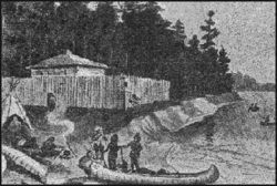
Depiction of Fort Rouillé, c. 1750s
|
|
| Coordinates | 43°37′50.23″N 79°25′24.80″W / 43.6306194°N 79.4235556°W |
| Type | Trading post |
| Site history | |
| Built | 1750–51 |
| In use | 1751–59 |
| Materials | Wood |
| Fate | Destroyed in 1759 |
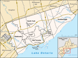
Fort Rouillé was a French trading post built in what is now Toronto, Ontario, Canada. The French constructed Fort Rouillé in 1751. It was built after a smaller trading post, Fort Toronto, had great success a year earlier. Fort Rouillé was named after Antoine Louis Rouillé, a French government official. He was the Secretary of State for the Navy under King Louis XV of France. The fort was an important place for trading with local Indigenous peoples.
The French soldiers at Fort Rouillé burned it down in July 1759. This happened after the French lost the Battle of Fort Niagara during the French and Indian War. The fort's remains were later removed in the 1800s. Today, the fort site is part of Exhibition Place in Toronto. An obelisk monument marks the spot, and the fort's original shape is outlined in concrete on the ground.
Contents
History of Fort Rouillé
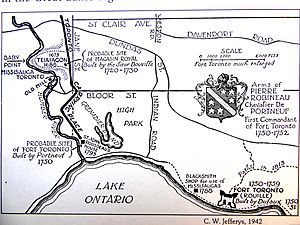
In the late 1600s and 1700s, the area around Toronto was a busy place. French fur traders often used it as a shortcut. They traveled to the upper Great Lakes and areas north of Toronto. The French wanted to protect this trade route from the British. So, they built a trading post called Magasin Royal (Fort Douville) in 1720. It was located along the Humber River. However, this post was abandoned after the British built Fort Oswego in 1727. Fort Oswego took away much of the trade.
Building Fort Toronto
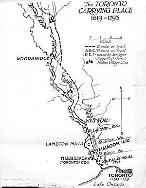
In 1750, the French built another trading post. They called it Fort Toronto. It was near the mouth of the Humber River. The goal was to stop Indigenous peoples from trading with the British at Fort Oswego. These groups often used the Toronto Carrying-Place Trail. Fort Toronto was very successful right away. It had more demand for goods than it could supply. Pierre Robineau de Portneuf built Fort Toronto. It was located near Grenadier Pond and the home of Jean Baptiste Rousseau. This fort was like other French outposts. It controlled an old river trade route.
Fort Rouillé is Built
The success of Fort Toronto led to a new plan. The Governor General of New France, the Marquis de la Jonquière, ordered a larger fort. This new fort would have more trading space and military power. It would help France control the region and its trade routes. Fort Rouillé was finished in the spring of 1751. It was built on the site of today's Exhibition Place. The new fort was named for Antoine Louis Rouillé, a French government minister. It was also known as Fort Toronto because it replaced the smaller post.
The fort was built to strengthen France's presence in the area. It also aimed to stop Indigenous people from trading with the British at Oswego. A report from Abbé Picquet noted that Indigenous people got more silver for their beaver furs at Oswego. They preferred French brandy, but it was not enough to keep them from Oswego. To stop this trade, French posts needed to offer the same goods at the same prices as Oswego. Since Indigenous people traveled south on the Toronto Carrying-Place Trail, the fort was placed in Toronto.
Abbé Picquet visited Fort Rouillé in 1752. He found good food and wine there. He said it was better equipped than other outposts. The Mississaugas, a local Indigenous group, wanted Picquet to build a church there. They felt the Iroquois, another Indigenous group, had been treated better.
War and Destruction
In 1756, Britain and France declared war. This was part of the Seven Years' War. In 1757, the Mississaugas looted the fort when the soldiers were away. A message was sent to Fort Niagara, and the French returned the next day. They took back the fort. The Mississaugas admitted to the plot. They said they thought the French had left and they were taking items away from the British. Captain Pierre Pouchot believed they only wanted the French brandy.
In 1758, orders were given to strengthen Fort Niagara. All soldiers and loyal Indigenous allies were called to defend it. Fort Rouillé continued to operate until 1759. The fort's soldiers were told to burn Fort Rouillé if Fort Niagara was captured. After the French lost the Battle of Fort Niagara in July 1759, the soldiers at Fort Rouillé burned it down. They then moved to Montreal. The British, led by Lieutenant Francis, found only burnt wood when they arrived.
After Fort Rouillé was destroyed, no new settlement was built there for over 30 years. Governor Simcoe started the town of York in 1793. This was about four miles east of the old French fort.
Fort Design
A description of the fort from that time explains its layout. It was at the end of the bay, on high ground. Ships could not get close enough to shoot at it. The fort was a square, about 180 feet (55 meters) on each side. It had strong corners called flanks. The buildings inside formed the walls of the fort. It was well-built but only useful for trade. A river, the Toronto River, was about a league (a few miles) west of the fort. This river connected to Lake Huron by a 15-league portage (a path where boats are carried). Indigenous people from the north used this route.
It was a small fort with a wooden fence, called a palisade. It had a strong point at each of its four corners. The fort was about 180 by 180 feet (55 by 55 meters). It had five buildings: a guardhouse, a storeroom, barracks for soldiers, a blacksmith shop, and a building for officers. A drawing from 1749 shows the fort near Lake Ontario. Today, the fort's location is about 100 meters from the lake. This is because the shoreline has been filled in over time.
A wall surrounded the fort. The main entrance faced south towards Lake Ontario. Captain Gother Mann's map from 1788, "Plan of the Proposed Toronto Harbour," shows the fort's layout. It shows the five buildings inside the fence and the shape of the fort.
Fort Rouillé Monument
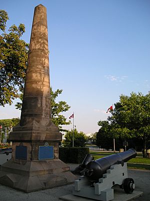
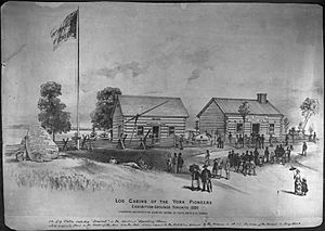
Parts of the fort remained for many years. When Toronto used the land for the Toronto Industrial Exhibition, the fort's mounds were leveled. To mark the spot, a large granite rock was placed there in 1878. It had an inscription saying it marked the exact spot of Fort Rouillé. In 1887, a large obelisk was put up to mark the spot where the French fort once stood. The site is now part of Exhibition Place.
Archaeologists excavated the site in 1979, 1980, and 1982. Two plaques, one in English and one in French, are on the base of the obelisk. They were placed there by the Ontario Heritage Trust. A third plaque to the north tells about the excavations. A fourth plaque to the west marks a visit by Bertrand Delanoë, the mayor of Paris, in 2003. A concrete outline of the original fort is marked on the ground.
The obelisk has a cannon and a mortar from the 1850s next to it. These are British. There used to be a second cannon on the west side, but it was removed after 2005.
A short street, Fort Rouille Street, is about 1 kilometer (0.6 miles) north of the fort site. It can be reached from Springhurst Avenue. This street once extended south to the fort.
Monument Plaque
The English plaque from the Ontario Heritage Foundation, placed in 1957, says:
The last French post built in present-day southern Ontario, Fort Rouillé, more commonly known as Fort Toronto, was erected on this site in 1750–51. It was established by order of the Marquis de La Jonquière, Governor of New France, to help strengthen French control of the Great Lakes and was located here near an important portage to capture the trade of Indians travelling southeast toward the British fur- trading centre at Oswego. A small frontier post, Fort Rouillé was a palisaded fortification with four bastions and five main buildings. It apparently prospered until hostilities between the French and British increased in the mid-1750s. After the evacuation of other French posts on Lake Ontario, Fort Rouillé was destroyed by its garrison in July 1759.
See also
 In Spanish: Fuerte Rouillé para niños
 | Madam C. J. Walker |
 | Janet Emerson Bashen |
 | Annie Turnbo Malone |
 | Maggie L. Walker |


