Lester, Alabama facts for kids
Quick facts for kids
Lester, Alabama
|
|
|---|---|

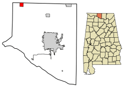
Location of Lester in Limestone County, Alabama.
|
|
| Country | United States |
| State | Alabama |
| County | Limestone |
| Area | |
| • Total | 1.91 sq mi (4.95 km2) |
| • Land | 1.91 sq mi (4.95 km2) |
| • Water | 0.00 sq mi (0.01 km2) |
| Elevation | 768 ft (234 m) |
| Population
(2020)
|
|
| • Total | 111 |
| • Density | 58.12/sq mi (22.44/km2) |
| Time zone | UTC-6 (Central (CST)) |
| • Summer (DST) | UTC-5 (CDT) |
| ZIP code |
35647
|
| Area code(s) | 256 |
| FIPS code | 01-42352 |
| GNIS feature ID | 2406007 |
Lester is a small town located in Limestone County, Alabama, in the United States. It's part of a larger area called the Huntsville-Decatur Combined Statistical Area. In 2020, about 111 people lived in Lester.
Contents
Geography of Lester
Lester is found in northern Alabama. Its exact location is 34°59′14″N 87°8′5″W / 34.98722°N 87.13472°W.
Land Area
The U.S. Census Bureau says that Lester covers a total area of about 1.8 square miles (4.95 square kilometers). All of this area is land.
People of Lester
The number of people living in Lester has changed over the years. Here's a quick look at its population:
| Historical population | |||
|---|---|---|---|
| Census | Pop. | %± | |
| 1970 | 70 | — | |
| 1980 | 117 | 67.1% | |
| 1990 | 89 | −23.9% | |
| 2000 | 107 | 20.2% | |
| 2010 | 111 | 3.7% | |
| 2020 | 111 | 0.0% | |
| U.S. Decennial Census 2013 Estimate |
|||
Population in 2000
According to the census from 2000, there were 107 people living in Lester. These people lived in 42 different homes. Most of the people living in Lester were white.
Education in Lester
Students in Lester attend schools that are part of the Limestone County School District.
See also
 In Spanish: Lester (Alabama) para niños
 | Emma Amos |
 | Edward Mitchell Bannister |
 | Larry D. Alexander |
 | Ernie Barnes |

