Lester, West Virginia facts for kids
Quick facts for kids
Lester, West Virginia
|
|
|---|---|

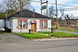
City Hall in Lester
|
|

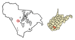
Location of Lester in Raleigh County, West Virginia.
|
|
| Country | United States |
| State | West Virginia |
| County | Raleigh |
| Area | |
| • Total | 0.50 sq mi (1.30 km2) |
| • Land | 0.50 sq mi (1.30 km2) |
| • Water | 0.00 sq mi (0.00 km2) |
| Elevation | 2,031 ft (619 m) |
| Population
(2020)
|
|
| • Total | 337 |
| • Estimate
(2021)
|
333 |
| • Density | 626.75/sq mi (241.86/km2) |
| Time zone | UTC-5 (Eastern (EST)) |
| • Summer (DST) | UTC-4 (EDT) |
| ZIP code |
25865
|
| Area code(s) | 304 |
| FIPS code | 54-46468 |
| GNIS feature ID | 2391270 |
Lester is a small town located in Raleigh County, West Virginia, in the United States. In 2020, about 337 people lived there. The town was named after Champ Lester, who was an early settler in the area.
Contents
Geography
Lester is found at a specific spot on the map: 37°44′5″N 81°18′4″W / 37.73472°N 81.30111°W. The town is built along a stream called Surveyor Creek. This creek is part of the Coal River system.
The town is mainly located where two state roads, Route 97 and Route 305, meet. Route 305 helps connect Lester to the larger Beckley area, which is just a few miles to the east.
According to the United States Census Bureau, Lester covers a total area of about 0.50 square miles (1.30 square kilometers). All of this area is land.
People of Lester
Population Changes Over Time
The number of people living in Lester has changed quite a bit over the years. Here's a quick look at the population from different census counts:
| Historical population | |||
|---|---|---|---|
| Census | Pop. | %± | |
| 1920 | 412 | — | |
| 1930 | 609 | 47.8% | |
| 1940 | 909 | 49.3% | |
| 1950 | 780 | −14.2% | |
| 1960 | 626 | −19.7% | |
| 1970 | 507 | −19.0% | |
| 1980 | 626 | 23.5% | |
| 1990 | 420 | −32.9% | |
| 2000 | 322 | −23.3% | |
| 2010 | 348 | 8.1% | |
| 2020 | 337 | −3.2% | |
| 2021 (est.) | 333 | −4.3% | |
| U.S. Decennial Census | |||
A Look at the People (2010)
In 2010, there were 348 people living in Lester. These people lived in 143 households, and 95 of these were families.
Most of the people in Lester were White (about 83.9%). About 13.8% were African American. A small number were Native American (0.3%) or from two or more races (2.0%). Less than 1% of the population was Hispanic or Latino.
- About 31.5% of households had children under 18 living with them.
- More than half (51.0%) of households were married couples living together.
- About 8.4% of households had a female head without a husband.
- About 7.0% had a male head without a wife.
- Roughly 28.7% of households were just one person living alone.
- About 15.4% of households were single people aged 65 or older.
The average age in Lester in 2010 was about 40.1 years old.
- About 25.3% of residents were under 18.
- About 6.3% were between 18 and 24.
- About 25% were between 25 and 44.
- Another 25.3% were between 45 and 64.
- About 18.1% were 65 or older.
The town had a fairly even split between genders, with about 49.1% male and 50.9% female residents.
See also
 In Spanish: Lester (Virginia Occidental) para niños
 | Kyle Baker |
 | Joseph Yoakum |
 | Laura Wheeler Waring |
 | Henry Ossawa Tanner |

