Lexington, Alabama facts for kids
Quick facts for kids
Lexington, Alabama
|
|
|---|---|

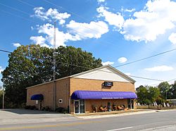
Lexington Town Hall
|
|

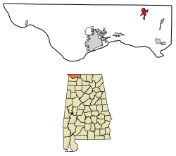
Location of Lexington in Lauderdale County, Alabama.
|
|
| Country | United States |
| State | Alabama |
| County | Lauderdale |
| Area | |
| • Total | 3.24 sq mi (8.39 km2) |
| • Land | 3.24 sq mi (8.38 km2) |
| • Water | 0.01 sq mi (0.01 km2) |
| Elevation | 764 ft (233 m) |
| Population
(2020)
|
|
| • Total | 727 |
| • Density | 224.66/sq mi (86.75/km2) |
| Time zone | UTC-6 (Central (CST)) |
| • Summer (DST) | UTC-5 (CDT) |
| ZIP code |
35648
|
| Area code(s) | 256 |
| FIPS code | 01-42640 |
| GNIS feature ID | 2406013 |
Lexington is a small town in Lauderdale County, Alabama, United States. It is part of a larger area called "The Shoals". This area includes the cities of Florence and Muscle Shoals. Lexington became an official town in 1959. In 2020, about 727 people lived there.
Contents
Geography and Location
Lexington is located in northern Alabama. Its exact spot on a map is 34°57′58″N 87°22′22″W / 34.96611°N 87.37278°W. The town covers about 3.2 square miles (8.3 square kilometers) of land.
Main Roads in Lexington
Two important state roads pass through Lexington:
Lexington's Climate
Lexington has a climate with warm summers and mild winters. The average high temperature in July is around 90 degrees Fahrenheit (32 degrees Celsius). In January, the average low temperature is about 31 degrees Fahrenheit (minus 0.5 degrees Celsius). The town gets a good amount of rain throughout the year.
People Living in Lexington
The number of people living in Lexington has changed over the years. A "census" is like a big count of everyone in a place.
| Year | Population |
|---|---|
| 1880 | 72 |
| 1960 | 315 |
| 1970 | 278 |
| 1980 | 884 |
| 1990 | 821 |
| 2000 | 840 |
| 2010 | 735 |
| 2020 | 727 |
Who Lives in Lexington (2020 Census)
The 2020 census showed that 727 people lived in Lexington. There were 366 households and 261 families. Most people living in Lexington are White.
| Group | Number of People | Percentage |
|---|---|---|
| White (not Hispanic) | 688 | 94.64% |
| Native American | 4 | 0.55% |
| Other/Mixed | 17 | 2.34% |
| Hispanic or Latino | 18 | 2.48% |
Education in Lexington
Lexington School is a public school in the town. It teaches students from kindergarten all the way to 12th grade. About 300 students go to this school. Lexington School is known for having test scores that are higher than the average for the area and the state of Alabama. The school's colors are purple and white, and their mascot is the Golden Bears.
Famous People From Lexington
- Frank Nunley was a professional American football player. He played as a linebacker for the San Francisco 49ers.
- Don Leslie Michael was a brave soldier who received the Medal of Honor. This is a very special award given for extreme bravery in battle. He received it after he passed away for his actions during the Vietnam War. He is buried in Lexington at Mount Pleasant Baptist Church.
Images for kids
See also
 In Spanish: Lexington (Alabama) para niños
 | William Lucy |
 | Charles Hayes |
 | Cleveland Robinson |


