
Liberty, Arizona facts for kids
Quick facts for kids
Liberty, Arizona
|
|
|---|---|

Liberty School (1910)
|
|

Location in Maricopa County and the state of Arizona
|
|
| Country | United States |
| State | Arizona |
| County | Maricopa |
| Elevation | 876 ft (267 m) |
| Time zone | UTC-7 (Mountain (MST)) |
| FIPS code | 04-40910 |
| GNIS feature ID | 6992 |
Liberty is a small community in Maricopa County, Arizona, United States. It's not officially a city or town, but a "populated place." It is located about 30 miles (50 kilometers) west of Phoenix. It is also about 6 miles (10 kilometers) southeast of Buckeye. You can find Liberty where South Jackrabbit Trail meets West Baseline Road. In 2000, only 63 people lived here.
The first people who settled here called the area Altamount. Later, it was known as Toothaker Place. This name came from Harriet Toothaker, who was the first postmaster. She ran the post office right out of her own home. In 1901, the post office moved to a new spot. At that time, the community was renamed Liberty.
Liberty is where the main office for the Liberty Elementary School District is located. This school district serves a much larger area. It includes parts of nearby towns like Buckeye and Goodyear. Liberty is like a small island of land that is not part of Buckeye, even though Buckeye surrounds it. This means Liberty cannot become its own city.
Contents
Meet a Notable Person from Liberty
John C. Butler: A War Hero
- John C. Butler was a brave person from Liberty. He was given the Navy Cross award. This is a very high honor for bravery in the U.S. Navy. He earned it for his actions during the Battle of Midway. This important battle happened during World War II.
Explore Historic Places in Liberty
Historic Buildings and Structures
- Historic structures
-
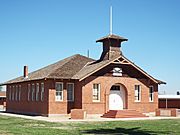
Liberty School was built in 1910. It is the oldest school in Arizona that is still being used today.
-
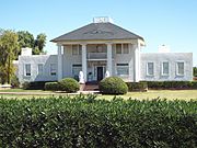
The "Old Spain House" is now called the Nardini Manor. It was built in 1886 and updated in 1912. You can find it at 5601 S 195th Ave.
-
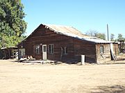
This is an old abandoned farm house on the land once owned by Joshua L. Spain.
-
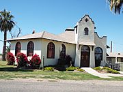
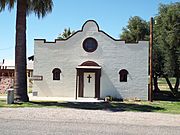
The Liberty Methodist Church was built in 1903. It is located on South Liberty School Road.
-
This is the Liberty Methodist Church Memorial Hall, also built in 1903.


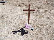
Visit the Historic Liberty Cemetery
A "historic cemetery" is one that has been around for more than 50 years. The Liberty Cemetery definitely fits this description!
- Historic Liberty Cemetery.
-
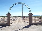
The Liberty Cemetery was started in 1885. It is located on South 207 Ave. Many of the first settlers of Buckeye are buried here.
-
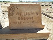
This is the grave of William "Bob" R. Beloat (1861–1954). He helped create the Buckeye Irrigation Company. He and his brother John were key in getting water to the company's ditch for the first time.
-
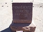
This is the grave of Thomas Newton ("Newt") Clanton (1843–1926). He was the person who founded the town of Buckeye. He moved to Arizona from Iowa because of his health.
-
This is the grave of Joe Chicken.


