
List of Indiana state historical markers in Jefferson County facts for kids

Jefferson County, Indiana, is home to many important historical markers. These markers are like special signs that tell us about significant people, places, and events from the past. They help us learn about the history of the area and the whole state of Indiana.
There are 16 official state historical markers in Jefferson County. Each one shares a unique story, from brave soldiers and important scientists to historic buildings and the fight for freedom. Let's explore some of these fascinating markers and the history they represent!
Contents
Exploring Jefferson County's History
Military Moments
Morgan's Raid: A Civil War Story
In 1863, during the American Civil War, a group of Confederate soldiers led by General John Hunt Morgan rode through Indiana. This event is known as Morgan's Raid. One marker, placed in 1963, tells us about this raid. It is located on State Road 7 in Dupont. This marker reminds us of the time when the war came close to home for many Hoosiers.
Honoring Brave Soldiers
Two markers celebrate military heroes from Jefferson County.
- Alois O. Bachman was a brave soldier. A marker placed in 1999 honors him near the Alois O. Bachman Bridge on State Road 7 in Madison.
- Samuel Woodfill was another incredible soldier. He received the Medal of Honor for his bravery during World War I. A marker for him was placed in 2018 at Grandview Memorial Gardens in Madison.

Business and Industry
Indiana's First Bank
Did you know that the first bank to get a special charter in Indiana was in Madison? The First Chartered Bank in Indiana marker, placed in 1966, is at 308 Jefferson Street in Madison. This bank was very important for helping businesses grow and for the economy of the early state.

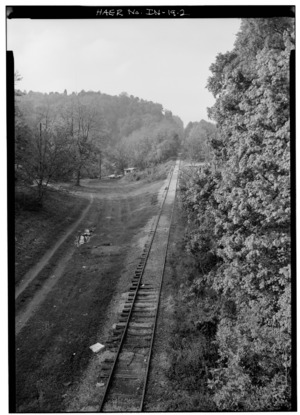
The Madison Hill Incline
Imagine a railroad track going straight up a steep hill! That's what the Madison Hill Incline and Cut was. This amazing piece of engineering helped trains carry goods up and down the steep hill in Madison. The marker, placed in 1996, is near 1001 W. Main Street in Madison. It reminds us of how important railroads were for transportation and trade long ago.
The Eagle Cotton Mill
The Eagle Cotton Mill was a big factory where cotton was spun into thread and fabric. A marker placed in 2022 at 108 St. Michaels Ave. in Madison tells its story. This mill was important for local jobs and industry, and it also played a role in the lives of many women who worked there.
James F.D. Lanier: A Key Figure
James F.D. Lanier was a very important businessman and lawyer in Indiana. He helped fund the state during the Civil War, showing his dedication to the Union. His marker, placed in 1963, is at the Lanier Mansion State Historic Site in Madison.

Science and Innovation
Harvey Washington Wiley: Food Safety Pioneer
Have you ever checked the ingredients on your food? You can thank Harvey Washington Wiley, M.D. for that! He was a scientist who worked hard to make sure our food and medicines were safe. He is often called the "father of the Pure Food and Drug Act." His marker, placed in 1981, is near Kent, Indiana, at the junction of State Road 256 and County Road 850W.

Historic Places and Communities
Madison's Historic District
The Madison Historic District is a special area in Madison with many old and beautiful buildings. It's like stepping back in time! A marker placed in 1992 at the junction of Vaughn Drive and Jefferson Street in Madison highlights this district. It shows how important it is to preserve old buildings and the unique character of a town.

Georgetown: A Community's Story
Georgetown was an important African American community in Madison. A marker placed in 2004 at the junction of Jefferson and Fifth Streets in Madison tells its story. This community played a role in the Underground Railroad and the fight for civil rights.
The Underground Railroad and Freedom
Several markers in Jefferson County tell the powerful story of the Underground Railroad, a secret network that helped enslaved people find freedom.
- Lyman Hoyt was a conductor on the Underground Railroad. His marker, placed in 2004, is near Lancaster on State Road 250.

- Eleutherian College was a special school that welcomed all students, regardless of their race or gender, which was very unusual at the time. It was also a stop on the Underground Railroad. A marker for it was placed in 2004 near Lancaster on State Road 250.

- John H. and Sarah Tibbets were also involved in the Underground Railroad. Their marker, placed in 2006, is in front of the Tibbets House near Madison.

- Chapman Harris was another important figure in the Underground Railroad. His marker, placed in 2016, is just east of Madison on Eagle Hollow Road and State Road 56. These markers remind us of the brave people who risked everything to help others find freedom.
Arts and Media
Irene Dunne: Hollywood Star
Irene Dunne was a famous actress who starred in many Hollywood movies. She was born in Indiana! Her marker, placed in 2006, is at 105 E. Main Street in Madison. It celebrates her contributions to arts and culture.

Michael C. Garber: Newspaper Man
Michael C. Garber was an important person in newspapers and politics in Madison. His marker, placed in 2004, is at the offices of The Madison Courier at 310 West Street in Madison. He helped share news and shape opinions in the community.
See also
- List of Indiana state historical markers
- National Register of Historic Places listings in Jefferson County, Indiana
