
List of Indiana state historical markers in Posey County facts for kids

Have you ever seen a special sign that tells a story about a place? These are called historical markers. They are like outdoor history books! They help us remember important people, events, or places from the past.
This article is about the official state historical markers you can find in Posey County, Indiana. These markers are placed by the Indiana Historical Bureau. Posey County has 5 of these cool markers, each telling a unique part of Indiana's history.
Contents
Historical Markers in Posey County
New Harmony: A Dream Community

The New Harmony marker was placed in 1966. It is located near 513 E. Church Street, right across from the post office in New Harmony.
New Harmony is a very special town. It was founded by two different groups of people who wanted to create perfect communities. First, the Harmonists built the town in the early 1800s. They were a religious group who lived and worked together. Later, a man named Robert Owen bought the town. He wanted to create a place where everyone was equal and focused on education and science. These ideas were very new for their time! The town is now a historic district because of its unique past.
Alvin P. Hovey: Soldier and Governor

The marker for Alvin P. Hovey was also placed in 1966. You can find it on the eastern side of Indiana State Road 69 at 5500 Industrial Road. It's by the entrance to Bellefontaine Cemetery, north of Mount Vernon.
Alvin P. Hovey (1821-1891) was an important person in Indiana's history. He was a brave military leader during the American Civil War. After the war, he became involved in politics. He even served as the Governor of Indiana! His marker helps us remember his contributions to the state.
New Harmony Workingmen's Institute: A Place for Learning

The New Harmony Workingmen's Institute marker was placed in 2001. It stands in front of the library at 407 W. Tavern Street in New Harmony.
The Workingmen's Institute is one of the oldest public libraries and museums in Indiana. It was created to help people learn and grow. It shows how much the people of New Harmony valued education and knowledge. This building is a great example of the town's focus on community and learning. It is also part of the town's historic district.
Tri-State Tornado: A Powerful Storm

The Tri-State Tornado marker was placed in 2004. You can see it at the southeastern corner of the junction of Main and First Streets in Griffin.
On March 18, 1925, a massive and deadly tornado swept through parts of Missouri, Illinois, and Indiana. It was one of the worst tornadoes in U.S. history. This powerful storm, known as the Tri-State Tornado, caused a lot of damage and sadly took many lives. The marker in Griffin reminds us of this incredible natural disaster and its impact on the community.
Griffin Oil Discovery: Black Gold in Indiana
The Griffin Oil Discovery marker was placed in 2006. It is located at Main and First Street in Griffin.
This marker celebrates an important moment for the town of Griffin. The discovery of oil nearby led to a big change for the area. Finding oil meant new jobs and new businesses. It was a significant event for the industry and economy of Posey County. This discovery also highlights the historic development of the region.
Images for kids
-

A street in historic New Harmony, Indiana
-
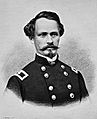
Portrait of General Alvin P. Hovey
-
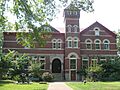
The New Harmony Workingmen's Institute building
-
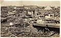
Damage from the 1925 Tri-State Tornado
See also
- List of Indiana state historical markers
- National Register of Historic Places listings in Posey County, Indiana
