
List of State Register of Heritage Places in the City of South Perth facts for kids
The State Register of Heritage Places is like a special list of important buildings and places in Western Australia. It's kept by the Heritage Council of Western Australia. As of 2024, there are 189 places in the City of South Perth that are recognized for their history. Out of these, 20 are so important they are on the State Register of Heritage Places. This means they are protected and valued for future generations.
Contents
Discovering South Perth's Heritage Gems
The City of South Perth is home to many fascinating historical sites. These places tell stories about how people lived, worked, and learned in the past. Let's explore some of these special locations that are officially listed on the State Register of Heritage Places.
Historic Schools and Colleges
South Perth has several schools and colleges that are important for their history and architecture.
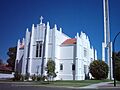
Wesley College, Chapel & Memorial Rose Garden

Wesley College, located at 20 Coode Street, is a well-known school. Its chapel and a beautiful rose garden are part of the heritage listing. This place has been important for education in the area for many years.
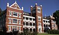
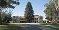
Aquinas College's Administration Building and Chapel

At 58 Mt Henry Road in Salter Point, you'll find Aquinas College. Its Administration Building and Chapel are listed as heritage sites. These buildings show the history of the college and its importance to the community.
Clontarf Aboriginal College

Clontarf Aboriginal College is at 295 Manning Road in Waterford. This college has a long history, once known as St Joseph's Boys Orphanage and Clontarf Boys Town. It plays a vital role in Aboriginal education and culture.
St Columba's Catholic Primary School

Located at 30 York Street, South Perth, St Columba's Catholic Primary School is also a heritage-listed site. It's part of a larger group of historic buildings that include St Columba's Church and St Joseph's Convent.
Important Churches and Religious Sites
Several churches and religious buildings in South Perth are recognized for their historical value.
St Columba's Church Group & St Joseph's Convent

At 25 Forrest Street in South Perth, you'll find the St Columba's Church Group & St Joseph's Convent. This group of buildings includes the church, the convent, and Dennehy House. They have been important places of worship and community gathering for a long time.
St Mary's Anglican Church Complex

The St Mary's Anglican Church Complex is at 9 Ridge Street, South Perth. This complex includes the Church Hall and St Mary's Church of the Virgin. It's a significant religious site in the area.
Saint Columba's Church

Also at 25 Forrest Street, South Perth, Saint Columba's Church is specifically listed. It's a key part of the larger St Columba's Church Group and St Joseph's Convent Precinct.
Dennehy House (former)

The former Dennehy House at 16 York Street, South Perth, is another heritage site. It's connected to the St Columba's Church Group and St Joseph's Convent, showing the history of the area's religious community.
Landmark Buildings and Public Spaces
South Perth also has several well-known buildings and public spaces that are part of its heritage.
Old Mill Theatre

The Old Mill Theatre is located on Lot 429, Mends Street, South Perth. This building has had many uses over the years, including a Mechanics' Institute and a school. Today, it's a popular theatre.
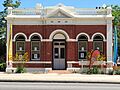
South Perth Police Station (former)

The old South Perth Police Station at 1 Mends Street, South Perth, is a heritage site. It reminds us of how law enforcement operated in the past.
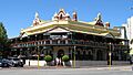
Windsor Hotel

The Windsor Hotel at 112 Mill Point Road, South Perth, is a famous landmark. It has been a popular place for people to stay and gather for many years.
Old Council Offices

The Old Council Offices at 111 Mill Point Road, South Perth, were once known as the Roads Board Building. Today, it's called South Perth Heritage House and is a cultural center.
Old Mill

The Old Mill is a very old building located on Lot 818, 833 Mill Point Road, South Perth. It was once known as Shenton's Mill and is one of the oldest surviving buildings in the area.
Pagoda, Como

The unique Pagoda building at 111 Melville Parade in Como is also heritage-listed. It has been a tea room and a restaurant, known for its distinctive design.
Cygnet Cinema

The Cygnet Cinema at 16 Preston Street in Como is a classic movie theatre. It was once called the Como Theatre and continues to be a beloved place for watching films.
Stidworthy Residence (former)

The former Stidworthy Residence at 130 Mill Point Road, South Perth, is a heritage home. It has also been known as La Petite Noir and Ladislav's Restaurant.
Important Bridges and Infrastructure
Some of the bridges that connect South Perth to other areas are also considered heritage places.
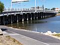
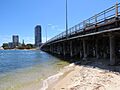
Canning Bridge (Eastbound and Westbound)


The Canning Bridge on Canning Highway, connecting Applecross and Como, is a very important heritage site. Both the eastbound and westbound sections of the bridge are listed. This bridge is crucial for transport and has a long history. It links the Cities of Melville and South Perth.
Narrows Bridge

The Narrows Bridge connects Perth and South Perth. It's a major landmark and a vital part of the city's transport system. This bridge is recognized for its engineering and historical significance.
Images for kids
-

Wesley College, a historic school in South Perth.
-

St Joseph's Convent, part of the St Columba's Church Group.
-
St Mary's Anglican Church Complex, a historic place of worship.
-

The Old Mill Theatre, a place for performances.
-

The former South Perth Police Station.
-
The historic Windsor Hotel in South Perth.
-
The Old Council Offices, now Heritage House.
-

The Old Mill, a very old and important landmark.
-
The impressive Administration Building at Aquinas College.
-
Clontarf Aboriginal College, a place of learning and history.
-

The unique Pagoda building in Como.
-
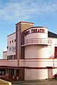
The classic Cygnet Cinema.
-
Canning Bridge, connecting different parts of the city.
-

The former Stidworthy Residence.
-
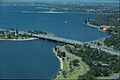
The Narrows Bridge, a major landmark.
-

Dennehy House, a historic residence.
-

St Columba's Catholic Primary School, part of a larger heritage group.
-
The westbound lanes of Canning Bridge.
-

Canning Bridge from a different view.
-

Saint Columba's Church, a beautiful historic building.
