
List of historic landmarks in Albuquerque, New Mexico facts for kids
Albuquerque is a city in New Mexico with many special places called historic landmarks. These are buildings, parks, or other sites that the city council has decided are very important to the city's history. Think of them like treasures from the past!
Once a place is named a historic landmark, it's protected. This means it can't be torn down or changed a lot without special permission. This helps make sure these important parts of Albuquerque's story last for a long time.
Some whole neighborhoods in Albuquerque are also considered historic. These include Barelas, Old Town Albuquerque, and Nob Hill. There are also historic spots in nearby towns like Belen and Rio Rancho.
Contents
Discovering Albuquerque's Historic Landmarks
Albuquerque has many amazing historic landmarks. Each one tells a unique story about the city's past. Many of these places are also listed on the National Register of Historic Places (NR) or the New Mexico State Register of Cultural Properties (SR). This means they are recognized as important not just locally, but across the state or even the whole country!
Cool Historic Buildings and Places
Here are some of the interesting historic landmarks you can find in Albuquerque:
AT&SF Locomotive 2926
Imagine a giant steam train! The AT&SF Locomotive 2926 is a huge old train engine. It's located at 1600 12th St. NW. This locomotive was added to the New Mexico State Register in 1975 and the National Register in 2007. It's a fantastic example of old railway technology.

AT&SF Memorial Hospital
The AT&SF Memorial Hospital is a historic building at 806 Central Ave. SE. It's part of a larger historic area called the Huning Highlands Historic District. This old hospital building has a lot of history within its walls.

KiMo Theater
The KiMo Theater is a very famous landmark at 423 Central Ave. NW. It's known for its unique Pueblo Deco style, which mixes Native American and Art Deco designs. It became a state landmark in 1976 and a national one in 1977. It's a beautiful place to see a show!

Old Airport Terminal
Before the modern Albuquerque International Sunport, there was the Old Airport Terminal. You can find it at 2920 Yale Blvd. SE. This building was important for early air travel in New Mexico. It was listed on the state register in 1976 and the national register in 1989.

Old Albuquerque High School
The Old Albuquerque High School stands at Central and Broadway NE. This grand building was where many generations of students learned. It became a state landmark in 1977 and is also part of the Huning Highlands Historic District.

Ernie Pyle House
The Ernie Pyle House at 900 Girard Blvd. SE was once the home of a famous World War II journalist, Ernie Pyle. It's now a library and a special place to remember his work. It was recognized as a state and national landmark in 1997.

Roosevelt Park
Roosevelt Park is a lovely green space located at Coal and Spruce SE. Parks are important historic landmarks too, as they show how communities grew and used public spaces. This park was added to both state and national registers in 1996.

Sunshine Building
The Sunshine Building is a cool historic building at 120 Central Ave. SW. It's known for its interesting architecture and has been a landmark since 1985. It's a great example of downtown Albuquerque's past.

Other Notable Landmarks
- De Anza Motor Lodge: A historic motel on Route 66, recognized in 2003 (SR) and 2004 (NR).
- El Vado Auto Court: Another famous Route 66 motel, listed in 1993 (SR and NR).
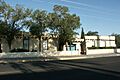
- Main Library: The city's main library, a state landmark since 2018 and national since 2019.
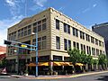
- Occidental Life Building: An important historic building downtown, recognized in 1973 (SR) and 1978 (NR).
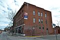
- Rosenwald Building: Another historic downtown building, listed in 1978 (SR and NR).
- Skinner Building: A historic structure recognized in 1980 (SR and NR).
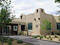
- Whittlesey House: A beautiful historic home, listed in 1975 (SR) and part of the Huning Highlands Historic District.
Landmarks That Are No Longer Standing
Sadly, not all historic landmarks last forever. Sometimes, old buildings are lost due to accidents or other reasons. Albuquerque has had a few landmarks that are no longer standing today.
For example, the AT&SF Railway Passenger Depot was a very important train station at 314 1st St. SW. It was a key part of travel in the city for many years. However, it was lost in a fire in 1993. Even though it's gone, it's still remembered as a historic landmark.
,_August_1972.jpg)
Images for kids
-

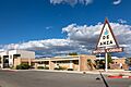
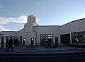
The North Façade and Great Hall of the Albuquerque International Sunport.
-
The De Anza Motor Lodge, a historic Route 66 spot.
-
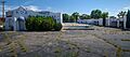
The El Vado Auto Court, another famous Route 66 landmark.
-
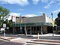
The Heights Community Center.
-
The historic Highland/Hudson Hotel.
-
The Jones Motor Company building.
-
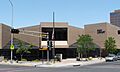
The modern Main Library building.
-
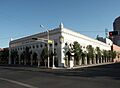
The Occidental Life Building.
-
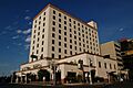
The Old Hilton Hotel, now known as Hotel Andaluz.
-
The Old Main Library building.
-
The Rosenwald Building.
-
The Skinner Building.
-
The historic Whittlesey House.
-
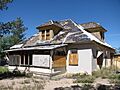
The Werner–Gilchrist House, a former landmark.


See also
