Little Shuswap Lake facts for kids
Quick facts for kids Little Shuswap Lake |
|
|---|---|
 |
|
| Location | British Columbia |
| Coordinates | 50°51′N 119°38′W / 50.850°N 119.633°W |
| Primary inflows | Little River |
| Primary outflows | South Thompson River |
| Basin countries | Canada |
| Max. length | 7.9 km (4.9 mi) |
| Max. width | 2.4 km (1.5 mi) |
| Surface area | 18.1 km2 (7.0 sq mi) |
| Average depth | 14.3 m (47 ft) |
| Max. depth | 59.4 m (195 ft) |
| Water volume | 260,634,324 m3 (9.2042143×10⁹ cu ft) |
| Surface elevation | 347 m (1,138 ft) |
| Islands | None |
| Settlements | Chase, British Columbia |
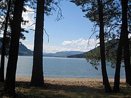
Little Shuswap Lake is a beautiful small lake in the southern part of British Columbia, Canada. It sits in a special spot, connecting the Thompson Country to the west with the Shuswap Country to the east. This lake is very important for the local water system.
Exploring Little Shuswap Lake
Little Shuswap Lake gets its water from the Little River. This river flows from the much larger Shuswap Lake. Little Shuswap Lake then feeds the South Thompson River, which starts at its southwestern end. The lake is about 7.8 kilometers (4.8 miles) long, running from northeast to southwest. It is usually around 2.4 kilometers (1.5 miles) wide. The total area of the lake is about 18 square kilometers (7 square miles).
How Deep is Little Shuswap Lake?
The average depth of Little Shuswap Lake is about 14.3 meters (47 feet). However, in some places, it can be much deeper. The deepest part of the lake reaches about 59.4 meters (195 feet). That's like stacking almost 10 school buses on top of each other!
Life Around the Lake
There are a few communities located around Little Shuswap Lake. The town of Chase is found at the southern end of the lake. The Secwepemc First Nations people call Chase Quaaout in their language. This community is a popular spot for recreation and has a rich history.
A smaller community called Squilax is located at the northern end of the lake. It sits on the north side, near where the Little River flows into the lake. Important transportation routes also follow the lake's eastern shore. These include the TransCanada Highway and the Canadian Pacific Railway. These routes help people and goods travel through this beautiful part of British Columbia.
 | Frances Mary Albrier |
 | Whitney Young |
 | Muhammad Ali |


