Littlejohn Island facts for kids
Quick facts for kids
Littlejohn Island, Maine
|
|
|---|---|

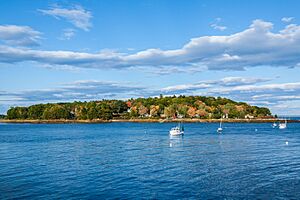
Littlejohn Island viewed from Cousins Island
|
|

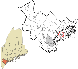
Location in Cumberland County and the state of Maine.
|
|
| Country | United States |
| State | Maine |
| County | Cumberland |
| Town | Yarmouth |
| Area | |
| • Total | 0.73 sq mi (1.89 km2) |
| • Land | 0.34 sq mi (0.88 km2) |
| • Water | 0.39 sq mi (1.01 km2) |
| Elevation | 93 ft (28 m) |
| Population
(2020)
|
|
| • Total | 116 |
| • Density | 339.18/sq mi (131.13/km2) |
| Time zone | UTC-5 (Eastern (EST)) |
| • Summer (DST) | UTC-4 (EDT) |
| Area code(s) | 207 |
| FIPS code | 23-40470 |
Littlejohn Island is a small island located in Maine, a state in the United States. It is also known as a census-designated place (CDP). This means it's an area that the government counts for population, but it's not officially a city or town.
Littlejohn Island is part of the town of Yarmouth in Cumberland County. In 2020, about 116 people lived there. The island is also part of a larger area that includes the cities of Portland, South Portland, and Biddeford. This bigger area is called a Metropolitan Statistical Area, which helps track population and economic information.
The island, along with Cousins River and Cousins Island, got its name from an English explorer named John Cousins. He lived a long time ago, from 1596 to 1682.
Island Location and Size
Littlejohn Island is found in a beautiful area called Casco Bay. You can find it on a map at these coordinates: 43 degrees, 45 minutes, 41 seconds North and 70 degrees, 7 minutes, 36 seconds West.
The island is connected to Cousins Island by a special road called a causeway. A causeway is like a bridge built over water to connect two pieces of land. From Cousins Island, another bridge connects to the mainland in Yarmouth. This makes it easy to travel to and from Littlejohn Island.
The total area of Littlejohn Island, including the water around it, is about 1.9 square kilometers (or 0.73 square miles). The land part of the island is about 0.88 square kilometers (0.34 square miles). The water area around the island is about 1.01 square kilometers (0.39 square miles). This means more than half of the CDP's area is water!
Who Lives on Littlejohn Island?
This section looks at the population of Littlejohn Island over time. This information is gathered during the U.S. Decennial Census, which happens every ten years.
- 2020: 116 people
See also
In Spanish: Littlejohn Island (Maine) para niños
 | William Lucy |
 | Charles Hayes |
 | Cleveland Robinson |

