Littleton, Maine facts for kids
Quick facts for kids
Littleton, Maine
|
|
|---|---|

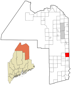
Location of Littleton, Maine
|
|
| Country | United States |
| State | Maine |
| County | Aroostook |
| Area | |
| • Total | 38.55 sq mi (99.84 km2) |
| • Land | 38.36 sq mi (99.35 km2) |
| • Water | 0.19 sq mi (0.49 km2) |
| Elevation | 472 ft (144 m) |
| Population
(2020)
|
|
| • Total | 997 |
| • Density | 26/sq mi (10.0/km2) |
| Time zone | UTC-5 (Eastern (EST)) |
| • Summer (DST) | UTC-4 (EDT) |
| ZIP code |
04730
|
| Area code(s) | 207 |
| FIPS code | 23-40595 |
| GNIS feature ID | 582565 |
Littleton is a small and friendly town in Aroostook County, Maine, United States. It's a great place to learn about local history and see how communities grow. In 2020, about 997 people called Littleton home.
Contents
A Look Back at Littleton's History
Littleton has an interesting past. Around the year 1800, a large piece of land in the southern part of what is now Littleton was given as a special land grant to Williams College. A year later, in 1801, the northern part of the land was given to Framingham Academy. People started settling in the area soon after these land grants. Littleton officially became a town in 1856.
Where is Littleton Located?
Littleton is located in the beautiful state of Maine. The United States Census Bureau says the town covers about 38.55 square miles (99.84 square kilometers). Most of this area, about 38.36 square miles (99.35 square kilometers), is land. A smaller part, about 0.19 square miles (0.49 square kilometers), is covered by water.
Littleton's Population Over Time
| Historical population | |||
|---|---|---|---|
| Census | Pop. | %± | |
| 1860 | 543 | — | |
| 1870 | 700 | 28.9% | |
| 1880 | 904 | 29.1% | |
| 1890 | 924 | 2.2% | |
| 1900 | 956 | 3.5% | |
| 1910 | 1,026 | 7.3% | |
| 1920 | 1,049 | 2.2% | |
| 1930 | 1,035 | −1.3% | |
| 1940 | 1,049 | 1.4% | |
| 1950 | 1,001 | −4.6% | |
| 1960 | 982 | −1.9% | |
| 1970 | 958 | −2.4% | |
| 1980 | 1,009 | 5.3% | |
| 1990 | 956 | −5.3% | |
| 2000 | 955 | −0.1% | |
| 2010 | 1,068 | 11.8% | |
| 2020 | 997 | −6.6% | |
| U.S. Decennial Census | |||
Understanding the 2010 Census Data
The census helps us understand how many people live in a place and what the community is like. In 2010, there were 1,068 people living in Littleton. These people lived in 420 different homes, and 290 of those were families.
The town's population density was about 27.8 people per square mile (10.7 people per square kilometer). There were also 469 housing units, which means there were 469 places where people could live.
Most of the people in Littleton in 2010 were White (91.7%). There were also people who identified as Native American (6.6%), African American (0.3%), and other races. Some people (1.3%) identified with two or more races. About 1.6% of the population was Hispanic or Latino.
Littleton Households and Age Groups
Out of the 420 homes in Littleton in 2010:
- About 33.1% of homes had children under 18 living there.
- 54.8% were married couples living together.
- 8.3% had a female head of the household without a husband present.
- 6.0% had a male head of the household without a wife present.
- 31.0% were not families, meaning individuals or unrelated people living together.
The average number of people in each home was 2.54. For families, the average size was 3.01 people.
The average age of people in Littleton was 40.8 years old.
- 25.4% of residents were under 18 years old.
- 6.4% were between 18 and 24 years old.
- 23.2% were between 25 and 44 years old.
- 29.4% were between 45 and 64 years old.
- 15.7% were 65 years of age or older.
When looking at gender, 52.1% of the population was male, and 47.9% was female.
See also
 In Spanish: Littleton (Maine) para niños
 | George Robert Carruthers |
 | Patricia Bath |
 | Jan Ernst Matzeliger |
 | Alexander Miles |

