Llano River facts for kids
Quick facts for kids Llano River |
|
|---|---|

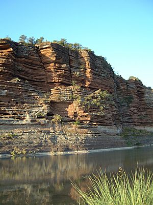
Sandstone bluffs along the Llano River, Mason County
|
|

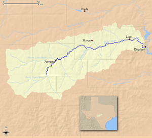
Map of the Llano River and associated watershed
|
|
| Country | United States |
| State | Texas |
| Region | Edwards Plateau |
| Physical characteristics | |
| Main source | Confluence of North and South Llano Junction, Edwards Plateau 827 m (2,713 ft) 30°29′33″N 099°45′22″W / 30.49250°N 99.75611°W |
| River mouth | Colorado River Kingsland, Texas Hill Country 252 m (827 ft) 30°39′19″N 98°25′46″W / 30.65528°N 98.42944°W |
| Length | 169 km (105 mi) |
The Llano River ( LAN-oh) is a river in Texas, United States. It's about 169 kilometers (105 miles) long. This river flows into the Colorado River. It helps drain a part of the Edwards Plateau in the Texas Hill Country, which is northwest of Austin.
Contents
Where the Llano River Begins
The Llano River starts from two smaller rivers. These are called the North Llano and the South Llano. Both of these smaller rivers are fed by natural springs. They flow through dry areas of West Texas.
These two rivers meet near a small town called Junction. This is in Kimble County. When they join, they form the main Llano River.
Journey Through Texas
The Llano River generally flows towards the east-northeast. It travels through the rolling hills of the Edwards Plateau. This area is known for its limestone rock.
The river passes through Kimble County and then through rural Mason County. It flows south of the town of Mason, Texas. As it continues east, the river cuts through a special area called the Llano Uplift.
The Llano Uplift
The Llano Uplift is a unique geological area. It's a roughly circular dome made of very old rock. This rock is mainly granite. It's located in Central Texas.
After this, the river flows through Llano County. It goes north of a famous natural landmark called Enchanted Rock. The river also flows right through the town of Llano, Texas.
Northeast of Llano, the river makes a sharp turn to the southeast. It then joins the Colorado River. This meeting point is part of Lake Lyndon B. Johnson. It's about 15 kilometers (9 miles) southeast of Llano, near Kingsland.
Fish and Fishing
The Llano River is a popular spot for fly fishing in Texas. Many different types of fish live here.
- Guadalupe bass: This is the official state fish of Texas!
- Largemouth bass: Another popular sport fish.
- Alligator gar: A large, ancient-looking fish.
- Sunfish: Various types of smaller fish that are fun to catch.
The Legend of Los Almagres Mine
The Llano River is also part of an old legend about a hidden mine. This mine is called the Los Almagres Mine. The word almagre means "red ochre" in Spanish.
The story says that in 1756, a Spanish official named Don Bernardo de Miranda went on an expedition. He was looking for rumors of rich mineral deposits in the north. The legend claims that Miranda found a cave near the Llano River. He reported that it contained amazing amounts of silver. People still search for this lost mine today!
 | Sharif Bey |
 | Hale Woodruff |
 | Richmond Barthé |
 | Purvis Young |


