
Lochmaben Stone facts for kids
Quick facts for kids The Lochmaben Stone |
|
|---|---|

The Lochmaben Stone from the south.
|
|
| Official name: Lochmaben Stone,standing stone & stone | |
| Reference no. | SM3378 |
| Lua error in Module:Location_map at line 420: attempt to index field 'wikibase' (a nil value). | |
The Lochmaben Stone is a huge standing stone found in a field. It's located about a mile west of the River Sark where it meets the Solway Firth. This ancient stone is part of what was once a larger stone circle. It dates back to around 3000 BC, making it over 5,000 years old!
The main stone, sometimes called the Lochmabonstone, has a long history. It's a very large rock, about 7 feet (2.1 meters) tall and 18 feet (5.5 meters) around. It weighs about ten tons. The stone is made of granite that has been shaped by glaciers over time. In the flat lands of the Solway Plain, this giant stone would have been a very important landmark for thousands of years.
Contents
What's in a Name? The Lochmaben Stone's History

The Lochmaben Stone has had many different names over the centuries. Some recent names include Lochmabonstone, Stormont, and Old Graitney stone.
Here are some of its older names:
- In 1398, it was called 'Clochmabenstane'.
- In 1409 and 1472, it was 'Loumabanestane'.
- In 1485, it was 'Lowmabanstane'.
- In 1494, it was 'Loughmabanestane'.
The words 'Cloch' and 'clach' mean 'stone' in modern Irish and Scottish Gaelic. In Welsh, 'llech' can mean a flat stone or tablet.
The name Mabon, a Celtic god, appears in all these names. This strongly suggests a link to this ancient god. It also helps connect this site to a Roman place called 'Locus Maponi'. This name is listed in an old Roman document called the Ravenna Cosmography. 'Locus Maponi' might mean the 'Loch' or 'Pool' of Mabon. This could suggest that the town of Lochmaben, 18 miles away, is the place mentioned.
Another name, Maporitum, is also in the Cosmography. This name means the 'Ford of Mabon'. A 'ford' is a shallow place in a river where you can walk or drive across. The name 'Solway' (as in Solway Firth) might come from 'Sul' (meaning the stone) and 'Wath' (a Viking word for 'wade' or 'ford'). This means the stone marked the northern end of an important river crossing on the River Esk.
The old Gaelic word cloch or Brittonic *clog is seen in the 1398 name 'Clockmabanstane'. This suggests the full name might mean the 'stone or burial place of Mabon'. The first 'C-' was likely dropped because of the influence of the nearby town name, Lochmaben. The town of Clackmannan is another example where a Gaelic word for stone is clearly linked to a stone in the town center.
Uncovering the Past: Archaeology of the Stone
The first detailed maps of the area, made between 1843 and 1882, called the Lochmaben Stone site a "Druidical circle (Remains of)". An old record book from the mapmakers says it used to have nine upright stones. These stones formed an oval shape covering about half an acre (2,000 square meters).
Today, only two of these stones are still visible. One is the large Lochmaben Stone itself. The other is a smaller stone, about 1 meter (3.3 feet) tall and 1.2 meters (3.9 feet) wide. It's less easy to spot, as it's now part of a nearby hedge. In 1845, another historical account also mentioned that a ring of large stones once stood here. Most of these stones were removed shortly before that time so farmers could plough the land.
In 1982, the Lochmaben Stone fell over. Before it was put back upright, archaeologists dug around it. They found that the stone had been placed in a shallow pit. They didn't find any ancient objects. However, they took a sample of oak and hazel charcoal from the pit. Using radiocarbon dating, they found the charcoal was from around 3275 BC. This helps us know how old the stone's placement is.
The God Mabon and the Stone

The name of the stone strongly suggests this place was important for the worship of the Celtic god Mabon (also called Maponus). The name 'Mabon' comes from an old Welsh word meaning 'son of'. It suggests a young, divine figure. Mabon was thought to be the special protector of the ancient Kingdom of Rheged. Places where people worshipped Mabon have been found in several other locations, like Birrens and Corbridge. Mabon might have been a god of good harvests and new life. The Romans even linked him to their god Apollo. Some historians, like Tolstoy, believed that Merlin (the famous wizard) might have led ceremonies at the Clochmabenstane.
Around the 7th century, a monk in Italy created a list of all the towns and road stops in the Roman Empire. This important document is called the Ravenna Cosmography. It mentions a place called 'Locus Maponi'. Many believe this 'Locus Maponi' is the site of the Lochmaben Stone.
The Lochmaben Stone and the Border
The Lochmaben Stone was a very well-known landmark on the border between Scotland and England. Because it was easy to find, it was used for many important meetings before Scotland and England became one kingdom. These meetings included arranging truces (temporary stops in fighting) and exchanging prisoners.
Meeting Point
Armies and raiding parties often met here before heading into England or preparing for defense. It was likely a gathering place for local tribes too. As late as 1557, an army was ordered to meet at the Lochmaben Stone.
Prisoner Exchange
In 1398, a prisoner exchange happened at the Lochmaben Stone. Representatives from England and Scotland met there. Prisoners were set free without needing to pay ransoms. Any ransoms already paid were to be given back.
Border Meetings
The use of the stone by border officials (called Wardens) shows that the Scots saw the Lochmaben Stone as the southernmost point of their land. In 1398, an agreement was made at 'Clochmabenstane' for people from certain English areas to meet at Kershope Bridge. The officials not only met here but also promised to behave well towards each other.
In 1398, an agreement stated that "The men of Galloway, Nithsdale, Annandale and Crawford Muir, shall meet with the Wardens of the West March for redress of claims at Clochmabanstane." This meant they would meet to sort out any problems or complaints.
In 1473, Scottish and English ambassadors agreed to hold more regular meetings at six recognized border sites. The Lochmaben Stone was one of these important meeting places. On March 26, 1494, officials from both countries met at the stone. They finally settled a long-running argument about a fishing area called the 'Fish Garth' on the River Esk.
In the 16th century, a record mentions the "Loughmaben Stone standing in Scotland, where we have been accustomed to keep days of marches." This shows its continued importance for border meetings.
The Stone's Recent Story
In the 1800s, the farmer who owned the land decided to clear his fields. He wanted to get rid of the three remaining stones because they made his field look messy and got in the way of his farm equipment. He started digging deep holes to bury the stones. One stone was completely buried, and another was partly buried. But then, the landowner, Lord Mansfield, arrived and stopped the work. The Lochmaben Stone was saved!
Even in more recent times, the stone was still used as a gathering place for people in the area. A local story says that a farm worker once moved the stone with an excavator. He was hoping to find 'treasure' hidden underneath it. The local primary school even attended an official ceremony when the stone was put back upright. This event was covered by the local newspaper, the Dumfries and Galloway Standard, on September 22, 1995.
Images for kids
-
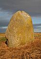
The Lochmaben Stone from the south.
-
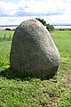
The main Lochmaben Stone from the north.
-
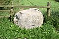
The smaller Lochmaben Stone incorporated into a hedge.
