Loher Cashel facts for kids
Quick facts for kids Loher Cashel |
|
|---|---|
| Native name Irish: Cathair an Lóthair |
|
 |
|
| Type | stone ringfort |
| Location | Loher, Derrynane, County Kerry, Ireland |
| Elevation | 60 m (200 ft) |
| Height | 3 m (9.8 ft) |
| Built | c. 9th century AD |
| Architectural style(s) | Gaelic Ireland |
| Owner | State |
| Official name: Loher Cashel | |
| Reference no. | 611 |
| Lua error in Module:Location_map at line 420: attempt to index field 'wikibase' (a nil value). | |
Loher Cashel is an ancient stone fort, known as a cashel, located in County Kerry, Ireland. It is a special place that has been protected as a National Monument. This means it's an important historical site that the government helps to look after.
Contents
What is Loher Cashel?
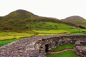
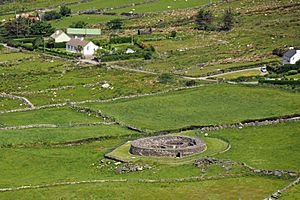
Loher Cashel is a type of ancient settlement called a ringfort. Imagine a circular wall made of stone, built to protect a farm or a small community. This cashel is made entirely of stone, without any mortar to hold the stones together. It's a great example of how people built strong structures a long time ago.
Where is Loher Cashel Located?

This amazing stone fort sits on the western side of the Iveragh Peninsula in County Kerry. It has a fantastic view of Ballinskelligs Bay. The people who built it probably chose this spot because they could see far across the land and sea. This helped them to spot anyone approaching. It also offered a clear view of Skellig Michael, a famous island with an ancient monastery.
A Glimpse into History
Loher Cashel was built a very long time ago, around the 9th century AD. This was a time when people in Ireland often lived in defended farmsteads like this. The cashel was a safe place where families lived and worked. It protected them and their animals from dangers. The fort has been carefully rebuilt in recent times to help us understand what it looked like originally.
Exploring the Cashel
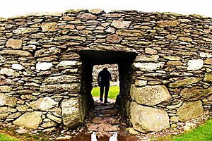
Loher Cashel is a circular fort. Its inner space is about 20 m (66 ft) across. The outer walls are very strong, standing over 2 m (6 ft 7 in) high and 3 m (9.8 ft) thick. You can even find stairways built into the walls, which allowed people to reach the top.
Inside the cashel, there are remains of buildings. You can see where a large round house once stood, along with a smaller rectangular house. Archaeologists, who study ancient sites, have found clues that these stone buildings were built after earlier wooden ones. There was also a hidden underground passage, called a souterrain, inside the circular house. These passages were often used for storage or as a safe hiding place. The entrance to Loher Cashel is a stone-lined passage, similar to what you might see at another famous stone fort called Staigue stone fort.
 | Frances Mary Albrier |
 | Whitney Young |
 | Muhammad Ali |


