Long Pond (Lakeville, Massachusetts) facts for kids
Quick facts for kids Long Pond |
|
|---|---|
| Lake Apponequet | |

Long Pond
|
|
| Location | Plymouth and Bristol County, Massachusetts, U.S. |
| Coordinates | 41°48′00″N 70°56′58″W / 41.80000°N 70.94944°W |
| Type | Natural freshwater lake |
| Primary inflows | Stream fed from marshes |
| Primary outflows | Long Pond River, aka Snake River |
| Basin countries | United States |
| Max. length | 4 mi (6.4 km) |
| Max. width | 1 mi (1.6 km) |
| Surface area | 1,721 acres (7.0 km2) |
| Average depth | 9 ft (2.7 m) |
| Max. depth | 12 ft (3.7 m) |
| Surface elevation | 54 ft (16 m) |
| Islands |
|
| Settlements | |
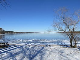
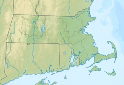
Long Pond is a large lake in southeastern Massachusetts. It covers about 1,721 acres (about 7 square kilometers). The lake is located in the towns of Lakeville and Freetown.
Long Pond shares its water with Assawompset Pond. Together, these lakes provide drinking water for New Bedford. This is the biggest city in southeastern Massachusetts.
The lake is about 1 mile (1.6 km) wide and 4 miles (6.4 km) long. It has three islands. In 1894, a dam was built on Assawompset Pond. This made Long Pond about 5 feet (1.5 meters) deeper. This change created Nelson Island. It also caused another island, Sunken Island, to disappear due to erosion. Today, only rocks remain where Sunken Island once was.
Long Pond is a popular spot for fishing and boating. Many homes are built around the lake. People can also find private spots to access the water.
Contents
Exploring Long Pond's Waterways
At the northeast part of the lake, there is a canal. This canal winds through an area called the Parkhurst development. You can even take a boat through it! A small bridge crosses the canal. It lets people walk or drive onto an artificial island.
In the northwest part of the lake, a river flows into Assawompset Pond. This river goes through marshland. It then passes under Route 18. Locals often call this river the "Snake River." On some maps, it is also known as the Long Pond River.
Islands of Long Pond
Long Pond is home to three main islands. They are listed from the southernmost to the northernmost island.
- Goat Island: This is the smallest island. It was recently bought by a private citizen from the Boy Scouts.
- Lewis Island: This is the largest island on the lake. It has sixteen privately owned cottages.
- Nelson Island: This island was bought in 2005. It is now a private home where people live all year.
Staying Safe on Long Pond
Boating on Long Pond can be a lot of fun. But, there are some areas that can be tricky for boaters. It is always good to be careful and know the lake.
Hidden Dangers for Boaters
- Sand Bar: A sand bar connects Nelson Island to the mainland. Its depth changes from about three feet to just a few inches. Sometimes, in late summer, it can even be completely out of the water.
- Shallow Water and Rocks: The lake is not very deep, averaging about nine feet (2.7 meters). Because of this, many large rocks can be a problem for boats. Most of these rocks are marked, but not all of them.
- Acre Rock: This is the biggest rock. It is flat on top and sits close to the water's surface. You can find it about a quarter-mile north of Hemlock Point. Acre Rock is located near the town line between Lakeville and Freetown.
- Sunken Island: This area is about 100 yards (91 meters) north of the northeast corner of Lewis Island. You might see birds resting on these rocks.
Tips for Boating Safely
If you are new to boating on Long Pond, here are some helpful tips:
- Stay West of Islands: When traveling north or south, try to stay on the western side of the islands. This helps you avoid many rocks and sandbars.
- Nelson Island Channel: When passing Nelson Island, stay in the middle of the channel. This is the space between the island and the shoreline. There are several rocks off the island's western tip.
- Southwestern Area: When you enter the lake's southwestern part, west of Hemlock Point, avoid the middle of the entrance. There are several rocks there that are not always marked.
In 1913, a powerboat called the Farina sank in Long Pond. This event reminds everyone about how important boat safety is on the water.
 | Toni Morrison |
 | Barack Obama |
 | Martin Luther King Jr. |
 | Ralph Bunche |


