
Assawompset Pond facts for kids
Quick facts for kids Assawompset Pond |
|
|---|---|

1893 Map of Assawompset Pond
|
|

Assawompset Pond
Location in Massachusetts

Assawompset Pond
Location in the United States
|
|
| Location | Lakeville and Middleboro, Massachusetts |
| Coordinates | 41°50′25″N 70°55′10″W / 41.84028°N 70.91944°W |
| Type | reservoir/lake |
| Primary inflows | Long Pond, Pocksha Pond |
| Primary outflows | Nemasket River |
| Basin countries | United States |
| Surface area | 2,404 acres (973 ha) |
Assawompset Pond is a large body of water located in southeastern Massachusetts. It is found within the towns of Lakeville and Middleboro. This pond is connected to Long Pond and Pocksha Pond. Together, these lakes supply drinking water to the city of New Bedford. Assawompset Pond is the biggest natural lake in Massachusetts, covering almost four square miles (10 km2).
Contents
What's in a Name?
The Wampanoag people, who are Native Americans, called this place Place of the White Stones. This name tells us something about the area's natural features.
Home to Fish
Assawompset Pond is famous for its large alewife run. Alewives are a type of herring fish. Every spring, the Nemasket River becomes full of these fish. They swim upstream from the ocean to lay their eggs in the pond. This event is a big deal for the local ecosystem.
A Place for Native Americans
The area known as Betty's Neck was a summer camp for Native Americans. They would travel along the Taunton River and Nemasket River to reach the pond. The Nemasket River was known as Where the fish are. This shows how important the river and pond were for food.
A Bit of History
Assawompset Pond is connected to the start of King Philip's War. This was a major conflict in early American history. A key event that helped spark the war happened near the pond.
The Damming of the Pond
In 1894, a dam was built on the Nemasket River at Assawompset Pond. This dam caused the water level of the pond to rise. It went up by about five feet (1.5 m). This change helped manage the water supply for the region.
Images for kids
-
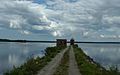
Assawompset Pond in Lakeville

