Lontué River facts for kids
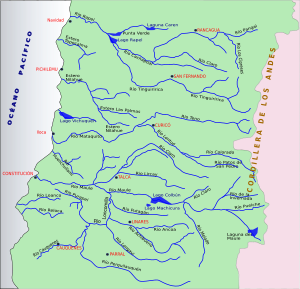
The Lontué River is an important river located in the Curicó Province of Chile. It is known for its clear waters and for being a key part of the region's water system. This river plays a role in the local environment and helps form a larger river downstream.
Contents
Where the Lontué River Begins
The Lontué River starts its journey about 50 kilometers (about 31 miles) east of the city of Curicó. It is formed when two other rivers, the Colorado River and the Los Patos River, join together. Imagine two streams meeting to create a bigger one!
The Source of Its Waters
Both the Colorado River and the Los Patos River get their water from high up in the mountains. Their sources are found near two impressive volcanoes: Descabezado Chico and Descabezado Grande. These volcanoes are part of the Andes mountain range, which means the Lontué River's water often comes from melting snow and ice.
The Lontué River's Journey
As the Lontué River flows, it travels through different landscapes in the Curicó Province. Its path is important for the local environment and for the communities living nearby. Rivers like the Lontué are vital for plants, animals, and people in the areas they pass through.
Joining Other Rivers
The Lontué River does not flow all the way to the ocean on its own. Instead, it meets another river called the Teno River. The Teno River flows from the north. When the Lontué River and the Teno River come together, they form a new, larger river known as the Mataquito River. This meeting point is about 10 kilometers (about 6 miles) west of Curicó, close to a town called Sagrada Familia. The Mataquito River then continues its journey towards the Pacific Ocean.
See also
- In Spanish: Río Lontué para niños
Sources
- Cuenca del río Mataquito
 | William M. Jackson |
 | Juan E. Gilbert |
 | Neil deGrasse Tyson |


