Mataquito River facts for kids
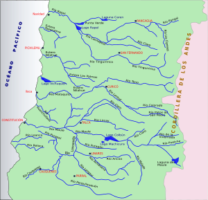
The Mataquito River is an important river in Chile. It is found in the Province of Curicó, which is part of the Maule Region. This river is formed when two other rivers, the Teno and the Lontué, join together.
This meeting point is about 10 kilometers (about 6 miles) west of the city of Curicó. It is also close to a small town called Sagrada Familia. After flowing for some distance, the Mataquito River eventually empties into the Pacific Ocean. Its mouth is located south of the coastal town of Iloca, near Licantén.
Contents
The Journey of the Mataquito River
The Mataquito River begins its journey in the central part of Chile. It is created from the waters of two other rivers. These are the Teno River and the Lontué River. Both of these rivers bring water from the Andes Mountains.
How the River Forms
The Teno River and the Lontué River flow down from the mountains. They meet and combine their waters to form the Mataquito River. This happens in a flat area west of Curicó. The joining of these two rivers creates a larger and more powerful waterway.
Flowing to the Pacific
Once formed, the Mataquito River flows westward. It travels through the landscape of the Maule Region. Finally, it reaches the coast and flows into the vast Pacific Ocean. This journey is important for the local environment. It also provides water for the surrounding areas.
Location and Importance
The Mataquito River is a key feature of the Maule Region. This region is known for its agriculture. Rivers like the Mataquito are vital for irrigation. They help farmers grow crops in the area.
The river also supports local wildlife. Many plants and animals depend on the river's waters. It is a natural habitat for various species. The river's path also shapes the landscape. It creates valleys and plains as it flows towards the sea.
See also
- Rivers of Chile
- Maule Region
 In Spanish: Río Mataquito para niños
 | Anna J. Cooper |
 | Mary McLeod Bethune |
 | Lillie Mae Bradford |


