
Curicó facts for kids
Quick facts for kids
Curicó
|
|||||
|---|---|---|---|---|---|

San Francisco Church before 2010
|
|||||
|
|||||
| Motto(s):
" Noble y Leal Villa de San José de Buena Vista de Curicó"
Noble and Loyal Villa of San José de Buena Vista from Curicó |
|||||
| Country | Chile | ||||
| Region | Maule | ||||
| Province | Curicó | ||||
| San José de Buena Vista de Curicó | October 9, 1743 | ||||
| Government | |||||
| • Type | Municipality | ||||
| Area | |||||
| • Total | 1,328.4 km2 (512.9 sq mi) | ||||
| Elevation | 228 m (748 ft) | ||||
| Population
(2012 Census)
|
|||||
| • Total | 136,954 | ||||
| • Density | 103.097/km2 (267.020/sq mi) | ||||
| • Urban | 100,506 | ||||
| • Rural | 19,079 | ||||
| Demonym(s) | Curican | ||||
| Sex | |||||
| • Men | 58,768 | ||||
| • Women | 70,817 | ||||
| Time zone | UTC-4 (CLT) | ||||
| • Summer (DST) | UTC-3 (CLST) | ||||
| Postal code |
3349001
|
||||
| Area code(s) | 56 + 75 | ||||
| Climate | Csb | ||||
| Website | Official website: http://www.curico.cl | ||||


Curicó (Spanish pronunciation: [kuri'ko]) is a city in Chile's central valley. It is the capital of the Curicó Province. This province is part of the Maule Region. Curicó is located between the Colchagua and Talca areas. The region stretches from the Pacific Ocean to the border with Argentina.
The city is famous for its special products. These include cakes, fruits, and tomato sauce. It also produces high-quality wines. Curicó is a major service center in central Chile. It is known as Chile's agro-industrial capital. This is because its economy grows steadily.
Contents
- What Does the Name Curicó Mean?
- What is the Curicó Coat of Arms?
- A Brief History of Curicó
- Where is Curicó Located?
- What is the Climate Like in Curicó?
- How Many People Live in Curicó?
- What is Curicó's Economy Like?
- Tourism and Fun in Curicó
- Education in Curicó
- Media in Curicó
- Famous People from Curicó
- Sports in Curicó
- How Curicó is Governed
- Images for kids
- See Also
What Does the Name Curicó Mean?
The name Curicó comes from the Mapudungun language. It means "black waters." Originally, it meant "land of black water."
What is the Curicó Coat of Arms?
The city's symbol is a special heraldic emblem. It shows the important traditions of Curicó's first Spanish settlers. The symbol has a silver knight on a black horse. This knight is on a green background. He is slaying a golden serpent. Below this image, it says "Noble and Loyal Villa de San José de Buenavista de Curicó." At the top, there is a golden crown.
This symbol was changed from the emblem of Lorenzo de Labra y Corvalán de Castilla. He owned the land where the city was built. The Spanish colony was about to use this symbol. But then the War of Independence began.
Before Curicó's 200th birthday, the Spanish community studied the symbol. They found the original coat of arms. A model of it is in the National Historical Museum in Santiago. On September 2, 1943, the city council officially made it the city's emblem. This happened a month before the city's anniversary.
The coat of arms is used in city events. It is also on official documents. You can see it on seals and stamps of the city government.
A Brief History of Curicó

The area of Curicó was first home to the Curis people. They were an indigenous group. They were named "black" because of the color of their lands near streams.
The city was founded on October 9, 1743. Its full name was San José de Buena Vista de Curicó. People like Captain Pedro Nolasco Solorza donated land for it. José Antonio Manso de Velasco, the governor of Chile, approved its founding.
In 1747, Governor Domingo Ortiz de Rozas moved the city. It was moved 3 kilometers east. This was because the old location was too wet. But the city only truly grew after an earthquake in 1751. This earthquake forced people to move to the new spot.
The oldest and most important building is La Iglesia San Francisco. This means "San Francisco's Church." It was built in 1734. It moved to its current spot in 1759.
Curicó became an official city in 1830. Luis Cruz Martínez is a Chilean military hero. He is celebrated in Curicó. The city is a key center for communication, trade, and business for nearby farms and factories.
The 2010 Chilean Earthquake greatly damaged Curicó. Many historic buildings collapsed. Sixty percent of houses and ninety percent of the historic area are still not rebuilt. For example, the San José de Curicó Hospital was rebuilt in stages.
Curicó is known for its strong local identity. People feel a good sense of community. Hero Luis Cruz Martínez and the local football club help this feeling.
Where is Curicó Located?
Curicó is located on the Guaiquillo River. It is about 183 kilometers south of Santiago. You can find it along the Chilean Central Railway route. The city is in the rich Chilean Central Valley. It is about 228 meters above sea level. This area is well-farmed. The eastern and western sides of the region have mountains. The Chilean Central Valley separates them. A volcano called Descabezado Grande can be seen from most parts of the city. It is about eighty kilometers away. The city area covers 1328.4 square kilometers.
The main rivers are the Lontué River and Teno River. They flow around the city. The landscape is mostly mountains. These include the Andes and the Chilean Coastal Range.
What is the Climate Like in Curicó?
Curicó has a warm-summer Mediterranean climate. This means it has hot, dry summers. Summers are from November to March. Temperatures can reach 32 degrees Celsius on the hottest days. Winters are from June to August. They are more humid. Typical daily high temperatures are around 15 degrees Celsius. The average rainfall is about 855.98 millimeters per year. In August 2007, it snowed in Curicó. This was the first time in over 60 years.
In the southern part of the valley, the climate is milder. There is also more rain. This helps the pasturage (grasslands for animals) grow better. Farmers use irrigation a lot to water their crops.
How Many People Live in Curicó?
According to the 2012 census by the National Statistics Institute, Curicó has 147,017 people. This includes 68,768 men and 70,817 women. Most people, 130,506 (84%), live in urban areas. The rest, 19,079 (16%), live in rural areas. Between the 1992 and 2002 censuses, the population grew by 14.9%. This was an increase of 15,472 people.
What is Curicó's Economy Like?
Farming and Agriculture
.jpg)
The city's economy mainly depends on farming. There are many large fruit farms. These include apple orchards, cherry trees, and kiwi farms. There are also many vineyards. Farmers also grow crops like sugar beets, industrial tomatoes, wheat, and corn.
Many companies that export fruit operate here. These include Agricom, Unifrutti, Copefrut, and Del Monte. The city also has wineries like Viña San Pedro, Concha y Toro, and Santa Rita. They make wine for Chile and other countries.
Businesses and Services

Curicó offers many services. These include banks, transportation, and department stores. There are also professional schools, universities, and hospitals. In 2012, Arauco opened a large particleboard factory here.
In 2007, Mall Curicó opened. It is a big shopping center. It has stores like Ripley, París, Jumbo, and Easy. The mall got bigger in 2018. It opened the first H&M store between Santiago and Concepción. In 2019, a special food area opened. It has restaurants like Burger King and Starbucks. It also brought Cineplanet and the Apple store MacOnline.
In 2019, Mercado Quadra started operating. It includes a Tottus supermarket. There are plans for a gym and more shops in the future.
In 2018, Curicó had 5,562 registered companies. The city's economy is strong in certain areas. These include making asphalt mixtures and producing seeds for flowers, fruits, and vegetables.
Tourism and Fun in Curicó
| population trend |
|
|---|---|
| year | inhabitants |
| 1895 | 12,669 |
| 1952 | 28,618 |
| 1960 | 34,646 |
| 1970 | 43,524 |
| 1982 | 63,658 |
| 1992 | 77,733 |
| 2002 | 119,585 |
| 2005 | 120,113 |
Curicó is known for its wine. It hosts the Fiesta de la Vendimia, or "Wine Harvest Festival," every year. This festival takes place from March 15 to 20. It celebrates the city's long history of winemaking. Curicó also has a wine route through the valley.

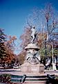
The Plaza de Armas is a main attraction. It is called a "Typical Zone." It has sixty phoenix palm trees from the Canary Islands. You can see sculptures and water fountains there. There is also an Eiffel-style iron kiosk. This kiosk is a National Monument. The square has bronze statues of the city's founder, José Antonio Manso de Velasco. There is also a monument to the toqui Lautaro.
The city's traditional cakes are called "tortas curicanas." They are very popular. In 1995, Tortas Montero made the world's largest cake. This earned them a spot in the Guinness World Records.
Cerro Condell is a hill in the city center. It is a popular place during national holidays. From the hill, you can see great views of the city. It has recreation areas and a monument to the Immaculate Conception. The Alameda Antonio Manso de Velasco avenue has gardens and trees. It runs through the city and leads to the San Francisco church. About 30 km from Curicó is Potrero Grande. It has mountains, forests, and waterfalls. It's a great place for hiking.
Education in Curicó
The city has two universities:
- Universidad de Talca (a public university)
- Universidad Católica del Maule (a religious university)
There are also other higher-education schools:
- Instituto Profesional DuocUC, part of the Pontificia Universidad Católica de Chile
- Instituto Profesional AIEP, part of the Universidad Andrés Bello
Media in Curicó
Curicó has one of Chile's oldest newspapers. It is called La Prensa de Curicó (Press of Curicó). It was founded in 1898. Before the 2010 earthquake, its offices were across from the main square. But the building collapsed, so they moved.
Famous People from Curicó
- Jorge Eduardo Álvarez (born 1990), a Chilean football player
Sports in Curicó
Curicó is known for its bicycle culture. Many Chilean cyclists who became famous internationally started riding here. These include Marco Arriagada, Marcelo Arriagada, and Luis Fernando Sepúlveda.
The local football (soccer) team is Club Provincial Curicó Unido.
How Curicó is Governed
Curicó is a commune. This is a local government area in Chile. It is run by a municipal council. The council is led by an alcalde (mayor). The mayor is chosen directly every four years. The mayor from 2012-2016 was Javier Muñoz Riquelme.
Curicó is part of the 36th electoral district. This district elects members to the Chamber of Deputies. The current representatives are Roberto León (PDC) and Celso Morales (UDI). This district also includes Teno, Romeral, Molina, Sagrada Familia, Hualañé, Licantén, Vichuquén, and Rauco.
For the Senate, Curicó is part of the 10th senatorial area (Maule-North). Its senators are Juan Antonio Coloma Correa (UDI) and Andrés Zaldívar Larraín (PDC).
Images for kids
-
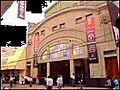
Victoria Theatre
-
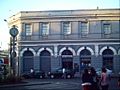
Diario La Prensa
-
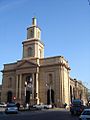
The main parish church around main square.
-
Luis Cruz Martínez, hero from Curicó.
-
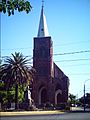
San Francisco Church, before being destroyed in the 2010 earthquake
-
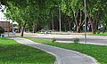
Curicó, Alameda, 2012
-
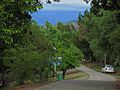
Cerro Condell, Curicó
-
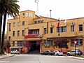
Correos de Chile (Post office) and Curicó's Municipalidad (City hall)
-
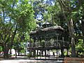
Kiosk in Curicó's Plaza de Armas


See Also
 In Spanish: Curicó para niños
