Rauco facts for kids
Quick facts for kids
Rauco
|
|||||
|---|---|---|---|---|---|
|
Town and Commune
|
|||||
 |
|||||
|
|||||
| Country | Chile | ||||
| Region | Maule | ||||
| Province | Curicó | ||||
| Government | |||||
| • Type | Municipality | ||||
| Area | |||||
| • Total | 308.6 km2 (119.2 sq mi) | ||||
| Elevation | 175 m (574 ft) | ||||
| Population
(2012 Census)
|
|||||
| • Total | 9,543 | ||||
| • Density | 30.924/km2 (80.092/sq mi) | ||||
| • Urban | 3,114 | ||||
| • Rural | 5,452 | ||||
| Sex | |||||
| • Men | 4,364 | ||||
| • Women | 4,202 | ||||
| Time zone | UTC-4 (CLT) | ||||
| • Summer (DST) | UTC-3 (CLST) | ||||
| Area code(s) | 56 + 75 | ||||
| Website | Municipality of Rauco | ||||
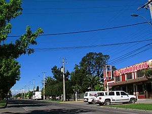
Rauco is a town and commune in Chile. It is located in the Curicó Province within the Maule Region. Rauco is mostly a countryside area, with about 60% of its people living in rural parts. It is just 10 kilometers away from the city of Curicó and covers an area of 308.6 square kilometers.
The name 'Rauco' comes from the Mapuche language, meaning "the land of chalky water". Rauco shares its borders with several other places: to the north is Chépica, to the east is Teno, to the south are Sagrada Familia and Curicó, and to the west is Hualañé.
| Top - 0-9 A B C D E F G H I J K L M N O P Q R S T U V W X Y Z |
People and Population in Rauco
How Many People Live Here?
According to a census taken in 2002 by Chile's National Statistics Institute, the Rauco commune had 8,566 residents. This included 4,364 men and 4,202 women.
Where Do People Live?
Of the total population, 3,114 people (about 36.4%) lived in urban areas, which are towns or cities. The majority, 5,452 people (about 63.6%), lived in rural areas, meaning the countryside. Between 1992 and 2002, Rauco's population grew by 9.5%, adding 744 more people.
Fun Things to Do in Rauco
Exploring Rauco's Outdoors
The road connecting Rauco with Curicó and Hualañé is great for cycling. You can enjoy a bike ride through the scenic area.
Visiting Local Attractions
Rauco has some interesting places to visit. One popular spot is the suspension bridge, also known as the Puente de Cimbra. It's just a few blocks from the town square. People often go there for picnics, swimming, and other fun activities.
Nature and Local Products
There's also a dam in the area called La Palmilla. Even though it's private property, visitors are sometimes allowed to camp there. It's also a good place for fishing for a type of fish called Basilichthys australis.
The area of El Parrón is famous for its delicious goat cheese. People there also raise sheep and goats. Other nearby areas include El Llano, known for its mushrooms and marmalade, and places like Majadilla, Palquibudi, and Tricao.
Historic Homes in Rauco
Like many communes in Curicó, Rauco has some old houses built in a colonial style. Some of these used to be the main homes on large estates, showing a bit of history.
How Rauco is Governed
Local Government and Leadership
Rauco is a commune, which means it has its own local government. It is managed by a municipal council. The leader of the commune is called an alcalde (mayor), who is chosen directly by the people every four years. The mayor from 2013 to 2017 was Enrique Olivares Farías, who belonged to the Social Democrat Radical Party.
See also
 In Spanish: Rauco para niños
 | Valerie Thomas |
 | Frederick McKinley Jones |
 | George Edward Alcorn Jr. |
 | Thomas Mensah |


