
Louisa, Virginia facts for kids
Quick facts for kids
Louisa, Virginia
|
||
|---|---|---|

Main Street, Downtown Louisa
|
||
|
||

Location in Virginia
|
||
| Country | United States | |
| State | Virginia | |
| County | Louisa | |
| Founded | 1873 | |
| Area | ||
| • Total | 1.84 sq mi (4.77 km2) | |
| • Land | 1.83 sq mi (4.73 km2) | |
| • Water | 0.01 sq mi (0.04 km2) | |
| Elevation | 466 ft (142 m) | |
| Population
(2010)
|
||
| • Total | 1,555 | |
| • Estimate
(2019)
|
1,733 | |
| • Density | 948.55/sq mi (366.28/km2) | |
| Time zone | UTC−5 (Eastern (EST)) | |
| • Summer (DST) | UTC−4 (EDT) | |
| ZIP Code |
23093
|
|
| Area code(s) | 540 | |
| FIPS code | 51-47144 | |
| GNIS feature ID | 1498507 | |
| Website | http://louisatown.org/ | |

Louisa is a small town in Louisa County, Virginia, United States. It was first called Louisa Court House. In 2010, about 1,555 people lived there. Louisa is the main town, or county seat, of Louisa County.
Contents
History of Louisa
Louisa Court House got its name from the county courthouse. This building was built in 1742. It was located near where Courthouse Road (now SR 208) and Main Street (now SR-22/US-33) meet. For over 100 years, this village was the county seat.
During the American Civil War, Louisa became a very important spot. It was key for Virginia's supply routes and communication lines.

In 1836, the Virginia General Assembly (Virginia's law-making group) approved the creation of the Louisa Railroad. This railroad later became the Virginia Central Railroad. Its main line went right through the village. On June 10, 1864, thousands of soldiers and horses camped near the courthouse. They were part of General Fitzhugh Lee's cavalry before the Battle of Trevilian Station.
The Virginia Central Railroad later joined with the Chesapeake and Ohio Railroad in 1868. This company operated the main rail line through Louisa for over 100 years.
The Town of Louisa officially became a town in 1873. Many businesses chose to set up shop near the railroad. This was especially true for big industries that needed to move heavy goods by train. As roads got better, especially after I-64 was built in 1956, businesses started using large trucks more often. Today, they mostly use US 33.
Historic Places to See
Louisa has many interesting historic spots. Some are important locally, and others are important for the whole country. These places include Bloomington, Boxley Place, the Louisa County Courthouse (built in 1905), and Louisa High School. These are all listed on the National Register of Historic Places. This means they are special places that are worth protecting.
Geography and Location
Louisa is located at 38°1′27″N 78°0′6″W / 38.02417°N 78.00167°W.
The town covers about 1.8 square miles (4.7 square kilometers) in total. Most of this area is land, with a very small amount of water.
Climate in Louisa
| Climate data for Louisa, Virginia (1991–2020 normals, extremes 1916–present) | |||||||||||||
|---|---|---|---|---|---|---|---|---|---|---|---|---|---|
| Month | Jan | Feb | Mar | Apr | May | Jun | Jul | Aug | Sep | Oct | Nov | Dec | Year |
| Record high °F (°C) | 80 (27) |
82 (28) |
89 (32) |
96 (36) |
99 (37) |
101 (38) |
108 (42) |
105 (41) |
104 (40) |
98 (37) |
88 (31) |
79 (26) |
108 (42) |
| Mean daily maximum °F (°C) | 45.2 (7.3) |
49.4 (9.7) |
58.2 (14.6) |
69.8 (21.0) |
76.0 (24.4) |
83.2 (28.4) |
86.7 (30.4) |
85.3 (29.6) |
79.0 (26.1) |
68.6 (20.3) |
57.4 (14.1) |
48.1 (8.9) |
67.2 (19.6) |
| Daily mean °F (°C) | 35.3 (1.8) |
38.2 (3.4) |
45.5 (7.5) |
56.1 (13.4) |
64.0 (17.8) |
71.9 (22.2) |
76.0 (24.4) |
74.4 (23.6) |
67.6 (19.8) |
56.5 (13.6) |
45.8 (7.7) |
38.1 (3.4) |
55.8 (13.2) |
| Mean daily minimum °F (°C) | 25.4 (−3.7) |
27.0 (−2.8) |
32.8 (0.4) |
42.3 (5.7) |
52.0 (11.1) |
60.7 (15.9) |
65.2 (18.4) |
63.6 (17.6) |
56.3 (13.5) |
44.4 (6.9) |
34.1 (1.2) |
28.1 (−2.2) |
44.3 (6.8) |
| Record low °F (°C) | −20 (−29) |
−21 (−29) |
−5 (−21) |
13 (−11) |
26 (−3) |
36 (2) |
37 (3) |
36 (2) |
29 (−2) |
18 (−8) |
4 (−16) |
−9 (−23) |
−21 (−29) |
| Average precipitation inches (mm) | 3.00 (76) |
2.74 (70) |
3.70 (94) |
3.38 (86) |
3.97 (101) |
4.33 (110) |
4.18 (106) |
3.68 (93) |
4.49 (114) |
3.81 (97) |
3.59 (91) |
3.33 (85) |
44.20 (1,123) |
| Average snowfall inches (cm) | 4.5 (11) |
6.1 (15) |
1.5 (3.8) |
0.3 (0.76) |
0.0 (0.0) |
0.0 (0.0) |
0.0 (0.0) |
0.0 (0.0) |
0.0 (0.0) |
0.0 (0.0) |
0.1 (0.25) |
3.3 (8.4) |
15.8 (40) |
| Average precipitation days (≥ 0.01 in) | 9.3 | 8.3 | 10.0 | 10.5 | 12.2 | 10.6 | 10.9 | 9.2 | 9.7 | 8.3 | 8.8 | 10.1 | 117.9 |
| Average snowy days (≥ 0.1 in) | 1.8 | 1.8 | 0.6 | 0.0 | 0.0 | 0.0 | 0.0 | 0.0 | 0.0 | 0.0 | 0.1 | 1.3 | 5.5 |
| Source: NOAA | |||||||||||||
People in Louisa
| Historical population | |||
|---|---|---|---|
| Census | Pop. | %± | |
| 1880 | 315 | — | |
| 1900 | 261 | — | |
| 1910 | 318 | 21.8% | |
| 1920 | 289 | −9.1% | |
| 1930 | 301 | 4.2% | |
| 1940 | 365 | 21.3% | |
| 1950 | 344 | −5.8% | |
| 1960 | 576 | 67.4% | |
| 1970 | 633 | 9.9% | |
| 1980 | 932 | 47.2% | |
| 1990 | 1,088 | 16.7% | |
| 2000 | 1,401 | 28.8% | |
| 2010 | 1,555 | 11.0% | |
| 2019 (est.) | 1,733 | 11.4% | |
| U.S. Decennial Census | |||
In 2000, there were 1,401 people living in Louisa. About 24.8% of the people were under 18 years old. The average age was 38 years.
Fun Things and Places of Interest
Louisa is home to the North Anna Nuclear Generating Station. This power plant makes electricity and provides many jobs for people in the county. The warm water from the plant flows into Lake Anna. This makes the lake a great place for fishing in Central Virginia.
Louisa also has the Twin Oaks Community. This is a special group of about 100 people who live and work together. They share resources and have been in Louisa since 1967.
The 2011 Virginia earthquake happened very close to Louisa. Its center was only about 7 miles (11 kilometers) south-southeast of the town. This earthquake was quite strong, measuring 5.8 in magnitude. People felt it as far away as Washington, D.C., New York City, and even Canada!
-
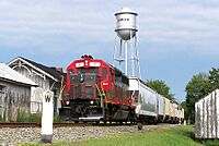
A local train of the Buckingham Branch railroad passes the C&O Depot and water tower in Louisa.
-

Cooper Vineyards in Louisa, is the first winery on the East Coast and the second in the country to be awarded the fourth and highest, Platinum certification by Leadership in Energy and Environmental Design (LEED)


Public Services
The Jefferson-Madison Regional Library system serves the people living in Louisa. This means residents can use the library's books and other services.
Famous People from Louisa
- Owen Smith, a racing car driver
- Kerry Wynn, a defensive end who played for the Cincinnati Bengals football team
- Brandon Smith, a linebacker who played for the Philadelphia Eagles football team
See also
 In Spanish: Louisa (Virginia) para niños
