Lower Matecumbe Key facts for kids

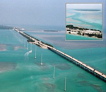
Aerial view of the causeway and bridge just northeast of Lower Matecumbe Key. The southwestern tip of the Upper Matecumbe Key is in the upper left. Indian Key can be seen in the inset.
|
|
| Geography | |
|---|---|
| Location | Gulf of Mexico |
| Coordinates | 24°51′58″N 80°42′43″W / 24.866°N 80.712°W |
| Administration | |
| State | Florida |
| County | Monroe |
Lower Matecumbe Key is a beautiful island in the upper Florida Keys, United States. You can find it along U.S. 1, between mile markers 75 and 78. Mile markers are like road signs that tell you how far you've traveled.
Since November 4, 1997, the entire island has been part of the Village of Islamorada. This means it's part of a local government area. Lower Matecumbe Key is also home to the main base of the Florida National High Adventure Sea Base. This is a cool place for Scouts to have amazing outdoor adventures.
The island is located southwest of Upper Matecumbe Key. It is also northeast of Craig Key.
History of Lower Matecumbe Key
Lower Matecumbe Key has a long history. It was once home to several ancient Indian sites. These sites included mounds and middens. Middens are like ancient trash heaps. They tell us a lot about how people lived long ago.
During the building of the Overseas Railroad, many of these historical sites were changed. The railroad was a big project. It connected the Florida Keys to the mainland.
Natural Wells and Sand Mining
In the past, there were natural wells on the island. These wells were at the northeast end of the key. Early sailors knew these wells well. They were the best source of fresh water in the Keys. Sadly, these wells were also lost during the railroad era. Their exact location is now unknown.
The southwestern part of the key was once used for sand mining. This means sand was dug up from the ground.
Fun Things to Do
A popular spot on the island is Anne's Beach. You can find it at mile marker 74. It is on the east side of the road, facing the ocean. It's a great place to relax and enjoy the water.
Education
Students living on Lower Matecumbe Key attend schools in the Monroe County School District. The local school for kids in kindergarten through eighth grade is Plantation Key School. This school is located on Plantation Key.
 | Misty Copeland |
 | Raven Wilkinson |
 | Debra Austin |
 | Aesha Ash |


