Lycan, Colorado facts for kids
Quick facts for kids
Lycan, Colorado
|
|
|---|---|

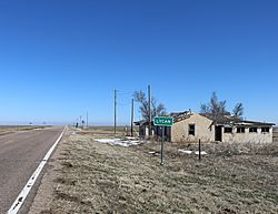
Looking east along State Highway 116 in Lycan.
|
|
| Country | |
| State | |
| County | Baca |
| Elevation | 3,862 ft (1,177 m) |
| Time zone | UTC-7 (MST) |
| • Summer (DST) | UTC-6 (MDT) |
| ZIP code |
81084 (Two Buttes)
|
| Area code(s) | 719 |
| GNIS feature ID | 196066 |
Lycan is a small, quiet place in Baca County, Colorado, United States. It's known as an "unincorporated community." This means it doesn't have its own local government like a city or town. Instead, it's part of the larger county. You can find Lycan about 37 miles east-northeast of a town called Springfield.
Contents
History of Lycan
What is an Unincorporated Community?
Imagine a small group of homes and maybe a few buildings that aren't officially a city or town. That's an unincorporated community! These places often started as small settlements, perhaps near a farm or a crossroads. They don't have their own mayor or city council. Instead, the county government handles services like roads and law enforcement.
Postal Services for Lycan
Even though Lycan doesn't have its own city government, people who live there still need mail service. The U.S. Post Office in a nearby town called Two Buttes helps with this. If you send mail to Lycan, it uses the ZIP Code 81084, which belongs to Two Buttes. This is common for unincorporated communities.
Geography of Lycan
Where is Lycan Located?
Lycan is situated in a part of Colorado that is mostly flat and open. It's easy to find because it sits right where two important roads meet: Colorado Highway 89 and Colorado Highway 116. These highways help connect Lycan to other towns and areas.
Lycan's Proximity to Kansas
This community is also quite close to the state border. If you travel just over five miles east from Lycan, you will cross into the neighboring state of Kansas. This makes Lycan a gateway to the eastern plains of Colorado and beyond.
 | Janet Taylor Pickett |
 | Synthia Saint James |
 | Howardena Pindell |
 | Faith Ringgold |

