
Lyndon, Kansas facts for kids
Quick facts for kids
Lyndon, Kansas
|
||
|---|---|---|
|
City and County seat
|
||

Downtown Lyndon (2009)
|
||
|
|
||

Location within Osage County and Kansas
|
||

|
||
| Country | United States | |
| State | Kansas | |
| County | Osage | |
| Founded | 1869 | |
| Incorporated | 1870 | |
| Named for | Lyndon, Vermont | |
| Area | ||
| • Total | 0.89 sq mi (2.31 km2) | |
| • Land | 0.89 sq mi (2.31 km2) | |
| • Water | 0.00 sq mi (0.00 km2) | |
| Elevation | 1,040 ft (320 m) | |
| Population
(2020)
|
||
| • Total | 1,037 | |
| • Density | 1,165/sq mi (448.9/km2) | |
| Time zone | UTC-6 (CST) | |
| • Summer (DST) | UTC-5 (CDT) | |
| ZIP code |
66451
|
|
| Area code | 785 | |
| FIPS code | 20-43350 | |
| GNIS ID | 479609 | |
Lyndon is a city in Kansas, United States. It is also the main town, or county seat, of Osage County. In 2020, about 1,037 people lived in Lyndon.
Contents
History of Lyndon
Lyndon was started in 1869. The land where the city now stands was once part of the Sac and Fox Nation. Later, the government made this land available for people to settle and build homes. The city was named after a town called Lyndon, Vermont.
Geography and Climate
Lyndon is located in Kansas at 38°36′37″N 95°41′7″W / 38.61028°N 95.68528°W. The city covers a total area of about 0.83 square miles (2.15 square kilometers). All of this area is land.
Lyndon's Climate
The weather in Lyndon has hot and humid summers. Winters are usually mild to cool. This type of weather is known as a humid subtropical climate. On climate maps, it is often shown as "Cfa."
Population and People
Lyndon is part of the larger Topeka metropolitan area. This means it's connected to the bigger city of Topeka.
| Historical population | |||
|---|---|---|---|
| Census | Pop. | %± | |
| 1890 | 935 | — | |
| 1900 | 1,004 | 7.4% | |
| 1910 | 763 | −24.0% | |
| 1920 | 732 | −4.1% | |
| 1930 | 742 | 1.4% | |
| 1940 | 751 | 1.2% | |
| 1950 | 729 | −2.9% | |
| 1960 | 953 | 30.7% | |
| 1970 | 958 | 0.5% | |
| 1980 | 1,132 | 18.2% | |
| 1990 | 964 | −14.8% | |
| 2000 | 1,038 | 7.7% | |
| 2010 | 1,052 | 1.3% | |
| 2020 | 1,037 | −1.4% | |
| U.S. Decennial Census | |||
2020 Population Details
In 2020, the 2020 United States census counted 1,037 people living in Lyndon. There were 424 households and 291 families. The population density was about 1,162 people per square mile.
About 28% of the people were under 18 years old. About 16.5% were 65 years old or older. The average age in Lyndon was 35.1 years.
2010 Population Details
The census in 2010 showed that 1,052 people lived in Lyndon. There were 422 households and 285 families. The population density was about 1,267 people per square mile.
About 28% of the residents were under 18 years old. About 13.9% were 65 years old or older. The average age in the city was 36.8 years.
Education
Students in Lyndon attend schools in the Lyndon USD 421 public school district.
Gallery
-
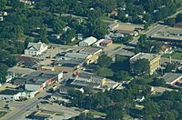
Aerial view of Lyndon (2013)
-
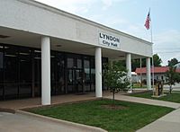
Lyndon City Hall (2009)
-

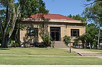
Osage County Courthouse (2009)
-
Lyndon Carnegie Library (2017)


See also
 In Spanish: Lyndon (Kansas) para niños
