
Längenfeld facts for kids
Quick facts for kids
Längenfeld
|
||
|---|---|---|
 |
||
|
||

Location in the district
|
||

Längenfeld
Location in Austria
|
||
| Country | Austria | |
| State | Tyrol | |
| District | Imst | |
| Area | ||
| • Total | 195.84 km2 (75.61 sq mi) | |
| Elevation | 1,179 m (3,868 ft) | |
| Time zone | UTC+1 (CET) | |
| • Summer (DST) | UTC+2 (CEST) | |
| Postal code |
6444
|
|
| Area code | 05253 | |
| Vehicle registration | IM | |
| Website | www.laengenfeld.tirol.gv.at | |

Längenfeld is a village and a local government area (called a municipality) in Austria. It is found in the Imst District in the state of Tyrol.
Längenfeld is about 25 kilometers (15.5 miles) southeast of the town of Imst. It sits in the beautiful Ötztal valley, which is a popular place for visitors. The village is also about 14 kilometers (8.7 miles) north of Sölden, another well-known spot.
Längenfeld is the largest place in the Ötztal valley. It covers an area of about 195.8 square kilometers (75.6 square miles). The area includes 21 smaller village parts. Around 4,333 people live there. One important building to see is the old church. It was first built in 1303 and has a mix of Gothic and Baroque styles. Most people in Längenfeld earn their living from tourism. Many visitors come to enjoy the valley's natural beauty and activities.
Population Changes
The number of people living in Längenfeld has changed over many years. Here is how the population has grown:
| Historical population | ||
|---|---|---|
| Year | Pop. | ±% |
| 1869 | 1,477 | — |
| 1880 | 1,485 | +0.5% |
| 1890 | 1,320 | −11.1% |
| 1900 | 1,262 | −4.4% |
| 1910 | 1,317 | +4.4% |
| 1923 | 1,424 | +8.1% |
| 1934 | 1,669 | +17.2% |
| 1939 | 1,700 | +1.9% |
| 1951 | 1,963 | +15.5% |
| 1961 | 2,314 | +17.9% |
| 1971 | 2,838 | +22.6% |
| 1981 | 3,146 | +10.9% |
| 1991 | 3,493 | +11.0% |
| 2001 | 4,063 | +16.3% |
| 2011 | 4,379 | +7.8% |
Images for kids
-

Panorama to Astlehn from Oberlängenfeld
-
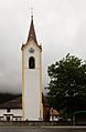
Church in Huben
-
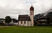
Chapel (Kapelle Mariahilf) in Dorf
-
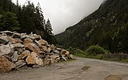
Boulders near the Waldwegbrücke in Aschbach
-
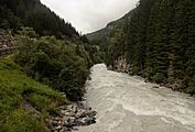
Ötztaler Ache in Aschbach
-
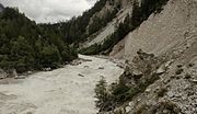
Ötztaler Ache between Längenfeld and Umhausen


See also
 In Spanish: Längenfeld para niños
