Mêdog County facts for kids
Quick facts for kids
Mêdog County
墨脱县 • མེ་ཏོག་རྫོང་།
|
|
|---|---|
|
County
|
|
 |
|
 |
|
| Country | People's Republic of China |
| Autonomous Region | Tibet |
| Prefecture-level city | Nyingchi |
| County seat | Metog |
| Area | |
| • Total | 6,600 km2 (2,500 sq mi) |
| Population
(2020)
|
|
| • Total | 14,889 |
| Time zone | UTC+8 (China Standard) |
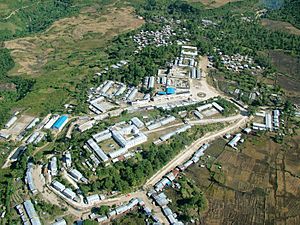
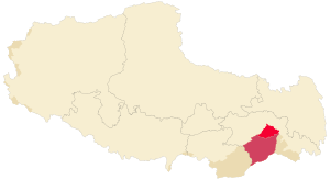
Mêdog (Tibetan: མེ་ཏོག་རྫོང་།, Wylie: me tog rdzong, ZYPY: Mêdog Zong; simplified Chinese: 墨脱县; traditional Chinese: 墨脫縣; pinyin: Mòtuō Xiàn) is a special place in the Tibet Autonomous Region of China. It is also known as Pemako, which means "Lotus Array." Mêdog is a county within the city of Nyingchi. It is famous for its beautiful nature and unique history.
Contents
Exploring Mêdog's Past
Mêdog has a long and interesting history. Around the year 618, the powerful Tibet Empire took control of this area. Later, in the early 1700s, a group of people called the Moinba started moving into the Medog region.
In 1780, a religious leader named the eighth Dalai Lama sent a monk to teach in Pemagang. This monk helped set up an important monastery there. Over time, different groups ruled the area. In 1919, the local government moved to Medog Village, and the area became known as Medogzong.
After 1951, Mêdog became part of the People's Republic of China. It was placed under different administrative areas over the years. Finally, in 2015, it became part of Nyingchi City.
Discovering Mêdog's Geography
Mêdog County is a large area, covering about 6,600 square kilometers. It is located in a special spot at the southern base of the Himalayas mountains. The mighty Yarlung Zangbo River flows right through it, from north to south.
The county is surrounded by tall mountains. To the north are the Kangri Karpo mountains. The west and northwest have high peaks of the Himalayas. The highest point, Namjagbarwa Peak, stands at an amazing 7,782 meters (about 25,531 feet) above sea level. The rivers have carved deep valleys into these mountains, sometimes more than two kilometers deep!
Mêdog's Climate and Weather
Because of the huge differences in height, Mêdog has many different climates. The weather changes a lot as you go up or down the mountains. In the valley areas, it's quite warm. The average temperature is between 18°C and 22°C (64°F-72°F). Even in January, the average temperature stays warm, between 12°C and 16°C (53°F-60°F).
Mêdog gets a lot of rain, usually between 2000-3000 mm (78-118 inches) each year. This heavy rainfall helps the area's plants grow very well.
Amazing Plants and Animals
Mêdog is home to many rare and protected plants and animals. The heavy rainfall means there are thick forests. At middle heights, you can find Northeastern Himalayan subalpine conifer forests. Lower down, there are Eastern Himalayan broadleaf forests. Higher up, the mountains are covered in Eastern Himalayan alpine shrub and meadows.
Many special wild plants and animals live here. China protects 3 types of plants and 17 types of animals in Mêdog at the highest level. There are also many other protected species, including 10 types of plants and 42 types of animals. It's a true natural treasure!
How Mêdog is Organized
Mêdog County is divided into smaller parts to help manage it. It has one main town, six townships, and one special ethnic township. In total, there are 45 administrative villages.
- Medog Town: This is the main town, with villages like Medog Village and Yadong Village.
- Beibeng Township: This area includes villages such as Beibeng Village and Didong Village.
- Damu Luoba ethnic Township: This is a special area for the Luoba ethnic group, with villages like Damu Village.
Life in Mêdog Today
In 2020, about 14,889 people lived in Mêdog County. Most of the people live in rural areas. The population includes several different ethnic groups. The largest groups are the Monba, Han, Lhoba, and Tibetan people.
What People Do
People in Mêdog mainly work in farming. They grow crops like rice, corn, and soybeans. They also grow fruits such as apples, bananas, and lemons. Some people work in crafts, making things from rattan, bamboo, and stone.
Connecting Mêdog to the World
For a long time, Mêdog was the last county in Tibet without a proper road. This meant it was very hard to get in and out. In 1994, a dirt road was built, but it was often damaged by landslides.
Finally, in 2013, the Zha-Mo Road was finished and opened. This was a huge step! It meant Mêdog was no longer cut off. As of 2019, Mêdog County has over 524 kilometers (about 325 miles) of highways, connecting its towns and villages. This has helped the county grow and connect with the rest of the world.
See also
 In Spanish: Medog para niños
 | Janet Taylor Pickett |
 | Synthia Saint James |
 | Howardena Pindell |
 | Faith Ringgold |

