Mackinac Trail–Carp River Bridge facts for kids
Quick facts for kids |
|
|
Mackinac Trail–Carp River Bridge
|
|

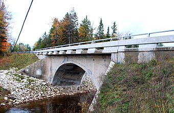
Bridge arch, 2012
|
|
| Location | Mackinac Trail over Carp R., St. Ignace Township, Michigan |
|---|---|
| Area | less than one acre |
| Built | 1920 |
| Built by | A. S. Decker |
| Architect | Michigan State Highway Department |
| Architectural style | spandrel arch |
| MPS | Highway Bridges of Michigan MPS |
| NRHP reference No. | 99001528 |
| Added to NRHP | December 17, 1999 |
The Mackinac Trail–Carp River Bridge is a special bridge in St. Ignace Township, Michigan. It crosses the Carp River on a road called H-63 (Mackinac Trail). This bridge is the oldest one in all of Mackinac County. Because it's so old and important, it was added to the National Register of Historic Places in 1999.
Contents
Building the Mackinac Trail Bridge
Work to improve the Mackinac Trail began in 1913. This trail was a major state highway connecting St. Ignace and Sault Ste. Marie. The project included making the road better and upgrading bridges along the way.
One of these bridges was over the Carp River. In 1919, the Michigan State Highway Department designed a concrete arch bridge for this spot. It was planned to be about 60-foot (18 m) long.
The job to build the bridge went to a company owned by A. S. Decker from Flint, Michigan. They finished building the bridge in 1920.
Changes Over the Years
Later, this part of the Mackinac Trail became part of U.S. Highway 2 (US 2). This meant a lot more cars started using the bridge. To handle the extra traffic, changes were made in 1929-1930.
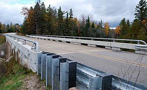
New guardrails were added to the bridge. The road surface on the bridge was made wider by about five feet (1.5 m). Also, new, fancy cobblestone paths were built leading up to the bridge.
Eventually, Interstate 75 replaced this section of US 2. The Mackinac Trail then became a county road, which is now known as H-63.
Saving the Bridge
In 2009, there was a plan to tear down the bridge. But in 2010, people decided to fix it up instead! This was great news for the old bridge.
Workers replaced concrete that had become weak. They also put in new drains to help with water. The road on the bridge was made even wider, by another five feet (1.5 m). Today, the Mackinac Trail–Carp River Bridge is still used by local cars and trucks.
What the Bridge Looks Like
The Mackinac Trail–Carp River Bridge is an arch bridge. This means it has a curved shape underneath, like a giant arch. The bridge is about 60 feet (18 m) long. The road on top is about 27 feet (8.2 m) wide.
The arch rests on large concrete supports called abutments. These supports have angled walls on the sides. The paths leading up to the bridge have cobblestone walls.
The first guardrails were taken off during the 1929-1930 widening project. They were replaced with decorative steel rails and concrete ends. Even though this design was called "standard," it seems to be special and not found on many other bridges in Michigan today. The Mackinac Trail–Carp River Bridge is one of the few remaining arch bridges built by the Michigan State Highway Department in its early days.
 | Precious Adams |
 | Lauren Anderson |
 | Janet Collins |


