Magdala, South Australia facts for kids
Quick facts for kids MagdalaSouth Australia |
|||||||||||||||
|---|---|---|---|---|---|---|---|---|---|---|---|---|---|---|---|

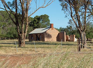
Former homestead immediately south of the intersection of Roennfeldt and Owen roads
|
|||||||||||||||
| Established | 1890s | ||||||||||||||
| Postcode(s) | 5400 | ||||||||||||||
| Location | 20 km (12 mi) N of Gawler | ||||||||||||||
| LGA(s) | Light Regional Council | ||||||||||||||
| State electorate(s) | Light | ||||||||||||||
| Federal Division(s) | Grey | ||||||||||||||
|
|||||||||||||||
Magdala is a small area in South Australia. It used to be a settlement, which means a place where people lived and had buildings. Today, it is mostly a rural area. Magdala is located about 20 kilometers north of a larger town called Gawler.
Contents
Exploring Magdala's Past
Magdala has an interesting history, even though not much of the original settlement remains today. It was once a small community with important buildings.
When Magdala Began
The settlement of Magdala started in the 1890s. This was a time when many new communities were forming in Australia. People moved to these areas to farm or work.
The Old School and Church
Magdala once had a school where children learned. This school was open from 1903 until 1940. There was also a church in the settlement. These places were important for the people living there.
Magdala's Location
Magdala is found on the road that connects Templers to Hamley Bridge. A railway line, called the Roseworthy-Peterborough railway line, also goes through the area. Railways were very important for travel and moving goods in the past.
What Remains Today
While the school and church are no longer there, one important part of the old settlement still exists.
The Magdala Cemetery
Today, the only remaining part of the original Magdala settlement is its cemetery. A cemetery is a place where people are buried. It helps us remember the people who lived in Magdala long ago.
 | Victor J. Glover |
 | Yvonne Cagle |
 | Jeanette Epps |
 | Bernard A. Harris Jr. |


