Magdalena, New Mexico facts for kids
Quick facts for kids
Magdalena, New Mexico
|
|
|---|---|
|
Village
|
|
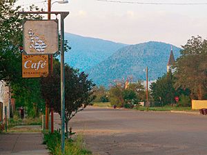
Main Street in Magdalena (2007)
|
|
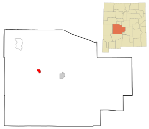
Location within Socorro County and New Mexico
|
|
| Country | United States |
| State | New Mexico |
| County | Socorro |
| Area | |
| • Total | 6.22 sq mi (16.12 km2) |
| • Land | 6.22 sq mi (16.12 km2) |
| • Water | 0.00 sq mi (0.00 km2) |
| Elevation | 6,664 ft (2,031 m) |
| Population
(2020)
|
|
| • Total | 806 |
| • Density | 129.50/sq mi (50.00/km2) |
| Time zone | UTC-7 (Mountain (MST)) |
| • Summer (DST) | UTC-6 (MDT) |
| ZIP code |
87825
|
| Area code | 575 |
| FIPS code | 35-46310 |
| GNIS ID | 2413570 |
Magdalena is a small village in Socorro County, New Mexico, United States. In 2020, about 806 people lived there.
Magdalena is famous for a rock formation called "The Lady on the Mountain." It's on Magdalena Peak, which looks over the village. Long ago, Spanish soldiers saw the shape of a woman's face on the mountain. A priest with them remembered a similar mountain in Spain named after Mary Magdalene. So, he called this New Mexico peak "La Sierra de Magdalena." The nearby pass and later the town got the same name.
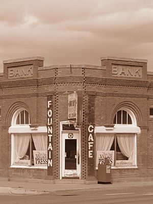
Today, Magdalena is still a place for ranching. It's also becoming known for its art, astronomy, and geology. Old buildings like the Magdalena Hall Hotel (built around 1917) have been fixed up. They help visitors imagine what life was like in the past. The local library and Boxcar Museum are in the old train station. You can also find rock and mineral shops from the time when mining was popular.
Many people visit Magdalena for its unique attractions. The nearby ghost town of Kelly is a popular spot. Two fun festivals, the "Open Studio and Gallery Tour" and the "Old Timers Reunion and Rodeo," also bring tourists. If you love stars, the "Enchanted Skies Star Party" happens in early fall. Astronomers gather here because the night sky is very dark and clear.
Magdalena is close to some important science sites. The Very Large Array, a huge radio telescope, is about 24 miles west. The Magdalena Ridge Observatory is about 25 miles southeast, high up at 10,600 feet. The village is also about 26 miles west of Socorro.
Contents
History of Magdalena
The village of Magdalena got its name from Magdalena Peak in 1884. That's when its post office first opened. Magdalena officially became a town in 1913. This happened during a time when mining was very busy in the area.
Magdalena is known as the "Trails End." This name comes from a special railroad line built in 1884. The New Mexico Railroad company built it from Socorro to Magdalena. Its main job was to carry cattle, sheep wool, timber, and ore. Thousands of cattle and sheep were herded into town from the west. They used a path called the "Magdalena Trail." This trail was used every year from 1885 to 1916. It was even made an official path by law. The trail continued to be used until 1971. You can still see the original stockyards today. The railroad line closed in 1970 and was later removed.
Geography and Climate
Magdalena is a village that covers about 6.2 square miles of land. It has no water area.
Weather in Magdalena
| Climate data for Magdalena, New Mexico (Elevation 6,664 ft (2,031 m)) | |||||||||||||
|---|---|---|---|---|---|---|---|---|---|---|---|---|---|
| Month | Jan | Feb | Mar | Apr | May | Jun | Jul | Aug | Sep | Oct | Nov | Dec | Year |
| Record high °F (°C) | 78 (26) |
75 (24) |
84 (29) |
90 (32) |
94 (34) |
102 (39) |
35 (2) |
36 (2) |
97 (36) |
89 (32) |
78 (26) |
75 (24) |
102 (39) |
| Mean daily maximum °F (°C) | 47.8 (8.8) |
52.3 (11.3) |
58.3 (14.6) |
66.9 (19.4) |
76.3 (24.6) |
85.9 (29.9) |
86.3 (30.2) |
83.8 (28.8) |
78.4 (25.8) |
69.4 (20.8) |
58.2 (14.6) |
49.4 (9.7) |
67.7 (19.8) |
| Mean daily minimum °F (°C) | 19.8 (−6.8) |
23.0 (−5.0) |
28.0 (−2.2) |
35.0 (1.7) |
43.4 (6.3) |
52.3 (11.3) |
56.7 (13.7) |
54.8 (12.7) |
48.7 (9.3) |
37.7 (3.2) |
27.0 (−2.8) |
20.7 (−6.3) |
37.3 (2.9) |
| Record low °F (°C) | −24 (−31) |
−6 (−21) |
0 (−18) |
10 (−12) |
20 (−7) |
34 (1) |
— | — | 20 (−7) |
10 (−12) |
−12 (−24) |
−21 (−29) |
−24 (−31) |
| Average precipitation inches (mm) | 0.47 (12) |
0.45 (11) |
0.49 (12) |
0.60 (15) |
0.60 (15) |
0.70 (18) |
2.47 (63) |
2.75 (70) |
1.63 (41) |
0.89 (23) |
0.40 (10) |
0.60 (15) |
12.04 (306) |
| Average snowfall inches (cm) | 2.0 (5.1) |
2.7 (6.9) |
0.8 (2.0) |
0.4 (1.0) |
0 (0) |
0 (0) |
0 (0) |
0 (0) |
0 (0) |
0.3 (0.76) |
0.6 (1.5) |
1.7 (4.3) |
8.4 (21) |
| Source: The Western Regional Climate Center | |||||||||||||
Population Information
| Historical population | |||
|---|---|---|---|
| Census | Pop. | %± | |
| 1920 | 1,867 | — | |
| 1930 | 1,371 | −26.6% | |
| 1940 | 1,323 | −3.5% | |
| 1950 | 1,297 | −2.0% | |
| 1960 | 1,211 | −6.6% | |
| 1970 | 652 | −46.2% | |
| 1980 | 1,022 | 56.7% | |
| 1990 | 861 | −15.8% | |
| 2000 | 913 | 6.0% | |
| 2010 | 938 | 2.7% | |
| 2020 | 806 | −14.1% | |
| U.S. Decennial Census | |||
In 2000, there were 913 people living in Magdalena. They lived in 372 households, and 244 of these were families. The village had a mix of people from different backgrounds. About half of the population was Hispanic or Latino.
About 30% of households had children under 18. Many households were married couples living together. The average household had about 2.45 people. The average family had about 3.06 people.
The population included people of all ages. About 27% were under 18 years old. About 16% were 65 years or older. The average age in the village was 41 years.
Local Media
In the late 1800s, Magdalena had a newspaper called the Magdalena Mountain Mail. It started in 1888 but soon joined with another paper. That combined paper didn't last long. Later, in the early 1900s, there were other newspapers like the Magdalena World and the Magdalena News.
In the second half of the 1900s, the Mountain Mail name came back. It was a monthly paper starting in 1979. Then, in 1992, a weekly version called the High Country Round-Up began. However, newspaper publishing in Magdalena ended in the 21st century. The Mountain Mail printed its last issue on June 27, 2013. It was the last newspaper in Socorro County that was owned by local people.
Education
The schools in Magdalena are part of the Magdalena Municipal Schools district.
Kelly Ghost Town
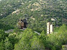
About 2.5 miles south of Magdalena, you can find the community of Kelly. The Kelly Mine opened there in 1883. This mine produced valuable metals like lead, silver, zinc, and smithsonite. At one point, nearly 3,000 people lived in Kelly during the mining boom.
However, when the market for these metals crashed, people started to leave. The last residents of Kelly moved away in 1947. Now, Kelly is a ghost town. The old Kelly Church is still standing. Sometimes, special events and celebrations are held there.
See also
 In Spanish: Magdalena (Nuevo México) para niños


