Magherafelt District Council facts for kids
Quick facts for kids Magherafelt District |
|
|---|---|
 |
|
| Area | 573 km2 (221 sq mi) Ranked 12th of 26 |
| District HQ | Magherafelt |
| Catholic | 66% |
| Protestant | 31.5% |
| Country | Northern Ireland |
| Sovereign state | United Kingdom |
| EU Parliament | Northern Ireland |
| Councillors | |
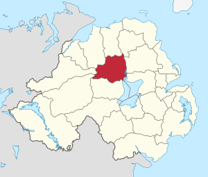
The Magherafelt District Council was a local government body in County Londonderry, Northern Ireland. It was like a local government team that looked after the Magherafelt area. This council existed until April 1, 2015.
On that date, it joined with two other councils: Cookstown District Council and Dungannon and South Tyrone Borough Council. Together, they formed a new, bigger council called the Mid-Ulster District Council. This change was part of a plan to reorganise local government in Northern Ireland.
Contents
What Was Magherafelt Council?
The main office for the Magherafelt District Council was in the town of Magherafelt. The area the council looked after stretched from Lough Neagh and the River Bann in the east. It went all the way to the Sperrin Mountains in the west. The Moyola River also flowed through this area.
The council's area covered about 554 square kilometres (214 square miles). Over 45,000 people lived there. One famous place in the area is Bellaghy. This is where the well-known poet Seamus Heaney was born in 1939.
How the Council Worked
The council was made up of 16 people who were chosen by local voters. These people were called "representatives" or "councillors." Local elections were held every four years. People voted using a system called proportional representation. This system tries to make sure that the number of seats each party gets is fair.
In the last election in May 2011, the councillors came from different political parties. Nine councillors were from Sinn Féin. Three were from the Democratic Unionist Party (DUP). Two were from the Social Democratic and Labour Party (SDLP). And two were from the Ulster Unionist Party (UUP).
Who Was in Charge?
Each year, the councillors chose a chairman and a vice-chairman. These leaders were picked at a special meeting in May or June. The very last chairman (for 2013/14) was Councillor Catherine Elattar from Sinn Féin. She represented the Magherafelt Town area. The vice-chairman was Councillor Anne Forde from the DUP. She represented the Sperrin area. It was special because it was the second time Magherafelt District Council had two women in these top leadership roles.
For elections to the Westminster Parliament (the main parliament in the UK), the Magherafelt area was part of the Mid Ulster constituency.
Elections and Voting
The table below shows the results of the 2011 local elections for the Magherafelt District Council. It shows how many seats each political party won.
| Party | seats | change +/- | |
|---|---|---|---|
| • | Sinn Féin | 9 | +1 |
| • | Democratic Unionist Party | 3 | -1 |
| • | Social Democratic and Labour Party | 2 | = |
| • | Ulster Unionist Party | 2 | = |
Electoral Areas
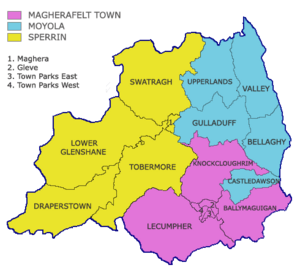
The Magherafelt District Council area was split into three main voting areas. These were called Magherafelt Town, Moyola, and Sperrin. Each of these areas was then divided into smaller sections called electoral wards. Magherafelt Town had six wards, while Moyola and Sperrin each had five.
The Big Change: Merging Councils
The change to merge councils was part of something called the "Review of Public Administration" (RPA). This plan aimed to create fewer, but larger, councils. Magherafelt District Council joined with Cookstown District Council and Dungannon and South Tyrone Borough Council. They formed the new Mid-Ulster District Council.
This new council covers a much bigger area, about 1714 square kilometres. It also serves a larger population of over 120,000 people. The new council was supposed to start earlier, but the process was delayed. The election for this new "super-council" finally happened in 2014, and the full reorganisation was completed in 2015.
How Many People Lived There?
According to the 2011 Northern Ireland census, the area covered by Magherafelt District Council had 45,038 residents. A census is like a big count of all the people living in an area.
 | Percy Lavon Julian |
 | Katherine Johnson |
 | George Washington Carver |
 | Annie Easley |


